
-
Federal
Aquarius Official Release Level 3 Sea Surface Density Standard Mapped Image Seasonal Data V5.0
National Aeronautics and Space Administration —
Aquarius Level 3 sea surface density standard mapped image data contains gridded 1 degree spatial resolution derived density averaged over daily, 7 day, monthly, and... -
Federal
Aquarius Official Release Level 3 Sea Surface Density Standard Mapped Image Monthly Data V5.0
National Aeronautics and Space Administration —
Aquarius Level 3 sea surface density standard mapped image data contains gridded 1 degree spatial resolution derived density averaged over daily, 7 day, monthly, and... -
Federal
BOREAS TF-01 SSA-OA Tower Flux, Meteorological, and Soil Temperature Data
National Aeronautics and Space Administration —
The BOREAS TF-01 team collected energy, carbon dioxide, and momentum flux data above the canopy along with meteorological and soils data at the BOREAS SSA-OA site... -
Federal
BOREAS Follow-On DSP-05 Process-Modeled Net Primary Productivity
National Aeronautics and Space Administration —
The BOREAS DSP-5 team generated a NPP image over the BOREAS region from a process-based ecosystem model, the Boreal Ecosystem Productivity Simulator (BEPS). The NPP... -
Federal
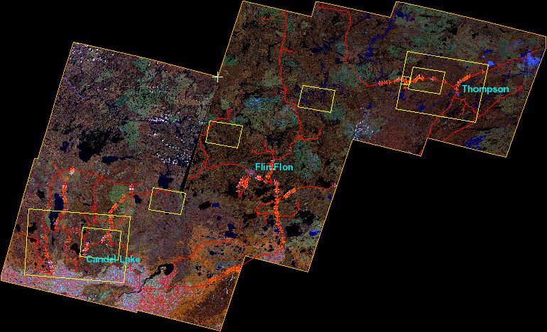
BOREAS Follow-On DSP-01 Landsat TM Land Cover Mosaic of the BOREAS Transect
National Aeronautics and Space Administration —
The objective of this land cover mosaic is to provide a data product that characterises the detailed land cover of a significant portion of the BOREAS Region. Seven... -
Federal
Aquarius Official Release Level 3 Sea Surface Spiciness Standard Mapped Image Descending 7-Day Data V5.0
National Aeronautics and Space Administration —
Aquarius Level 3 sea surface spiciness standard mapped image data contains gridded 1 degree spatial resolution spice data averaged over daily, 7 day, monthly, and... -
Federal
Earth Radiation Budget Experiment (ERBE) S-10N (Nonscanner-only) Wide Field of View (WFOV) Shape Factor (SF) Earth Flux and Albedo
National Aeronautics and Space Administration —
ERBE_S10N_WFV_SF_NAT_1 is the Earth Radiation Budget Experiment (ERBE) S-10N (Non-scanner-only) Wide Field of View (WFOV) Shape Factor (SF) Earth Flux and Albedo data... -
Federal
Earth Radiation Budget Experiment (ERBE) S-10 Wide Field of View (WFOV) Shape Factor (SF) Earth Flux and Albedo
National Aeronautics and Space Administration —
ERBE_S10_WFOV_SF_NAT_1 is the Earth Radiation Budget Experiment (ERBE) S-10 Wide Field of View (WFOV) Shape Factor (SF) Earth Flux and Albedo data product. Data... -
Federal
CMS: Mangrove Canopy Height from High-resolution Stereo Image Pairs, Mozambique, 2012
National Aeronautics and Space Administration —
This data set provides canopy height estimates for mangrove forests at 0.6 x 0.6 m resolution in three study sites located in southeastern Mozambique, Africa: two... -
Federal
BOREAS TGB-01 CH4 & CO2 Chamber Flux Data: NSA
National Aeronautics and Space Administration —
Chamber flux measurements were taken at the Northern Study Area (NSA) Old Jack Pine (OJP), Young Jack Pine (YJP), Old Black Spruce (OBS), and Beaver Pond (BP) sites... -
Federal
BOREAS TE-06 Biomass and Foliage Area Data
National Aeronautics and Space Administration —
The BOREAS TE-06 team collected several data sets in support of its efforts to characterize and interpret information on the plant biomass, allometry, biometry,... -
Federal
BOREAS TE-06 1994 Soil and Air Temperatures in the NSA
National Aeronautics and Space Administration —
The BOREAS TE-06 team collected several data sets to examine the influence of vegetation, climate, and their interactions on the major carbon fluxes for boreal forest... -
Federal
ATom: In Situ Data from Caltech Chemical Ionization Mass Spectrometer (CIT-CIMS), V2
National Aeronautics and Space Administration —
This dataset provides the concentrations of gas-phase organic and inorganic analytes measured by the California Institute of Technology (CIT) Chemical Ionization Mass... -
Federal
Aquarius Official Release Level 3 Sea Surface Density Standard Mapped Image Ascending Monthly Climatology Data V5.0
National Aeronautics and Space Administration —
Aquarius Level 3 sea surface density standard mapped image data contains gridded 1 degree spatial resolution density data averaged over daily, 7 day, monthly, and... -
Federal
Aquarius Official Release Level 3 Sea Surface Density Standard Mapped Image Ascending Monthly Data V5.0
National Aeronautics and Space Administration —
Aquarius Level 3 sea surface density standard mapped image data contains gridded 1 degree spatial resolution density data averaged over daily, 7 day, monthly, and... -
Federal
Aquarius Official Release Level 3 Sea Surface Density Standard Mapped Image Ascending 7-Day Data V5.0
National Aeronautics and Space Administration —
Aquarius Level 3 sea surface density standard mapped image data contains gridded 1 degree spatial resolution density data averaged over daily, 7 day, monthly, and... -
Federal
Aquarius Official Release Level 3 Sea Surface Density Standard Mapped Image Ascending Annual Data V5.0
National Aeronautics and Space Administration —
Aquarius Level 3 sea surface density standard mapped image data contains gridded 1 degree spatial resolution density data averaged over daily, 7 day, monthly, and... -
Federal
Aquarius Official Release Level 3 Sea Surface Density Standard Mapped Image Ascending Daily Data V5.0
National Aeronautics and Space Administration —
Aquarius Level 3 sea surface density standard mapped image data contains gridded 1 degree spatial resolution density data averaged over daily, 7 day, monthly, and... -
Federal
BOREAS/SRC AMS Suite B Surface Meteorological and Radiation Data: 1995
National Aeronautics and Space Administration —
The Saskatchewan Research Council (SRC) collected surface meteorological and radiation data from December, 1993 until Decemb er 1996. The data set is comprised of the... -
Federal
BOREAS/SRC AMS Suite B Surface Meteorological and Radiation Data: 1994
National Aeronautics and Space Administration —
The Saskatchewan Research Council (SRC) collected surface meteorological and radiation data from December, 1993 until Decemb er 1996. The data set is comprised of the...

Official websites use .gov
A
.gov website belongs to an official government
organization in the United States.
Secure .gov websites use HTTPS
A
lock (
) or https:// means you’ve safely connected to
the .gov website. Share sensitive information only on official,
secure websites.