
-
Federal
ECCO Ocean Velocity - Daily Mean 0.5 Degree (Version 4 Release 4)
National Aeronautics and Space Administration —
This dataset contains daily-averaged ocean velocity interpolated to a regular 0.5-degree grid from the ECCO Version 4 revision 4 (V4r4) ocean and sea-ice state... -
Federal
MISR Level 1B1 Local Mode Radiance Data V002
National Aeronautics and Space Administration —
MIB1LM_002 is the Multi-angle Imaging SpectroRadiometer (MISR) Level 1B1 Local Mode Radiance Data version 2. It contains the data numbers (DNs) radiometrically scaled... -
Federal
NWS Daily Climatology Data: 1986 (SNF)
National Aeronautics and Space Administration —
Weather data were collected by the National Weather Service in International Falls, Minnesota. International Falls is about 80 miles from the SNF, but the weather... -
Federal
MODIS/Terra+Aqua BRDF/Albedo QA ValidobsBand5 Daily L3 Global 30ArcSec CMG V006
National Aeronautics and Space Administration —
The MCD43D37 Version 6 data product was decommissioned on July 31, 2023. Users are encouraged to use the MCD43D37 Version 6.1 data product.The MCD43D37 Version 6... -
Federal
Polar Radiant Energy in the Far InfraRed Experiment (PREFIRE) Cloud Properties from PREFIRE Satellite 1 R01
National Aeronautics and Space Administration —
Polar Radiant Energy in the Far InfraRed Experiment (PREFIRE) Satellite 1 Cloud Properties (PREFIRE_SAT1_2B-CLD) contains cloud properties derived from data collected... -
Federal
NOAA-07 AVHRR Atmospherically Corrected Normalized Difference Vegetation Index Daily L3 Global 0.05 Deg. CMG
National Aeronautics and Space Administration —
The Long-Term Data Record (LTDR) produces, validates, and distributes a global land surface climate data record (CDR) that uses both mature and well-tested algorithms... -
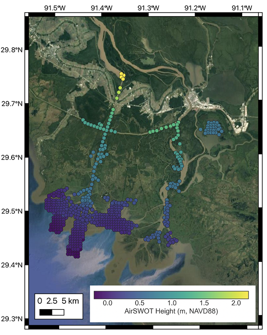
Federal
Delta-X: Calibrated ANUGA Hydrodynamic Outputs for the Atchafalaya Basin, MRD, LA
National Aeronautics and Space Administration —
This dataset provides ANUGA hydrodynamic modeling results and input run-scripts for the Atchafalaya basin in the Mississippi River Delta in southern Louisiana, USA,... -
Federal
ABoVE: Post-Fire and Unburned Vegetation Community and Field Data, NWT, Canada, 2019
National Aeronautics and Space Administration —
This dataset provides vegetation community characteristics, soil moisture, and biophysical data collected in 2019 from 11 study areas, which contained 28 sites that... -
Federal
LBA-ECO CD-05 Forest Understory Fuel Loads, Paragominas, Para, Brazil: 2001
National Aeronautics and Space Administration —
This data set contains estimates of understory fuel loads (forest litter) at six locations near Paragominas in Northeastern Amazonia. Samples were collected from... -
Federal
RSS CCMP Monthly 10 Meter Surface Winds Level 4 Version 3.1
National Aeronautics and Space Administration —
This data set contains a monthly-mean, 0.25 degree resolution, near-global gridded analysis of ocean surface winds (wind speed, components, and anomalies) from the... -
Federal
Ground-Based Global Navigation Satellite System (GNSS) Indian Regional Navigation Satellite System (IRNSS) Broadcast Ephemeris Data (30-second sampling, hourly files) from NASA CDDIS
National Aeronautics and Space Administration —
This dataset consists of ground-based Global Navigation Satellite System (GNSS) Indian Regional Navigation Satellite System (IRNSS) Broadcast Ephemeris Data (hourly... -
Federal
GRIP DC-8 METEOROLOGICAL MEASUREMENT SYSTEM (MMS) V1
National Aeronautics and Space Administration —
The GRIP DC-8 Meteorological measurement System (MMS) dataset was collected by the Meteorological Measurement System (MMS), which provides high-resolution, accurate... -
Federal
EXOSAT/CMA High Galactic Latitude Survey
National Aeronautics and Space Administration —
A survey of serendipitous source performed in the very soft X-ray band (0.05-2.0 keV) using the EXOSAT imaging telescopes is presented. The survey covers 783 square... -
Federal
Derby (DRBY) Ground-based Vector Magnetic Field (L2) 0.5 s Data
National Aeronautics and Space Administration —
Derby, VT, Ground-based Vector Magnetic Field Level 2 Data, 0.5 s Time Resolution, Station Code: (DRBY), Station Location: (GEO Latitude 45.0, Longitude 287.9),... -
Federal
IBEX High Energy Neutral Atom Imager (ENA-Hi) Data Release 10, not Compton-Getting corrected, Survival Probability corrected, Ram direction, West Longitude Ecliptic Maps, 1 year averaged data, Level H3
National Aeronautics and Space Administration —
This IBEX-Hi data set is from Release 10 of all-sky map data for the first seven years, 2009-2015, in the form of ram direction Hydrogen, H, energetic neutral atom... -
Federal
IBEX High Energy Neutral Atom Imager (ENA-Hi) Data Release 10, Compton-Getting corrected, not Survival Probability corrected, Ram direction, West Longitude Ecliptic Maps, 1 year averaged data, Level H3
National Aeronautics and Space Administration —
This IBEX-Hi data set is from Release 10 of all-sky map data for the first seven years, 2009-2015, in the form of ram direction Hydrogen, H, energetic neutral atom... -
Federal
AIRS/Aqua L3 Monthly Support Product (AIRS+AMSU) 1 degree x 1 degree V006 (AIRX3SPM) at GES DISC
National Aeronautics and Space Administration —
The Atmospheric Infrared Sounder (AIRS) is a grating spectrometer (R = 1200) aboard the second Earth Observing System (EOS) polar-orbiting platform, EOS Aqua. In... -
Federal
Aqua/AIRS L3 Daily Support Product (AIRS-only) 1 degree x 1 degree V7.0 at GES DISC
National Aeronautics and Space Administration —
The Atmospheric Infrared Sounder (AIRS) is a grating spectrometer (R = 1200) aboard the second Earth Observing System (EOS) polar-orbiting platform, EOS Aqua. In...

Official websites use .gov
A
.gov website belongs to an official government
organization in the United States.
Secure .gov websites use HTTPS
A
lock (
) or https:// means you’ve safely connected to
the .gov website. Share sensitive information only on official,
secure websites.