
-
Federal
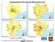
U.S. Population Grids (Summary File 1), 2000: Houston Metropolitan Statistical Area, Alpha Version
National Aeronautics and Space Administration —
The U.S. Population Grids (Summary File 1), 2000: Houston Metropolitan Statistical Area, Alpha Version data set contains an ARC/INFO Workspace with grids of... -
Federal
Daily and Annual PM2.5 Concentrations for the Contiguous United States, 1-km Grids, Version 1.10 (2000-2016)
National Aeronautics and Space Administration —
The Daily and Annual PM2.5 Concentrations for the Contiguous United States, 1-km Grids, Version 1.10 (2000-2016) data set includes predictions of PM2.5 concentration... -
Federal
INFORM Global Risk Index 2019 Mid Year, v0.3.7
National Aeronautics and Space Administration —
The INFORM Global Risk Index 2019 Mid Year, v0.3.7 data set identifies the countries at a high risk of humanitarian crisis that are more likely to require... -
Federal
Sub-global Scenarios that Extend the Global SSP Narratives: Literature Database, Version 1, 2014-2021
National Aeronautics and Space Administration —
The Sub-global Scenarios that Extend the Global SSP Narratives: Literature Database, Version 1, 2014-2021 consists of 37 columns of bibliographic data, methodological... -
Federal
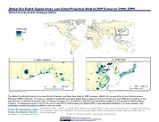
Global One-Eighth Degree Urban Land Extent Projection and Base Year Grids by SSP Scenarios, 2000-2100
National Aeronautics and Space Administration —
The Global One-Eighth Degree Urban Land Extent Projection and Base Year Grids by SSP Scenarios, 2000-2100 consists of global SSP-consistent spatial urban land... -
Federal
2001 Environmental Sustainability Index (ESI)
National Aeronautics and Space Administration —
The 2001 Environmental Sustainability Index (ESI) utilizes a refined methodology based on the 2000 Pilot ESI effort, to construct an index covering 122 countries that... -
Federal
Archive of Census Related Products (ACRP): 1990 Public Use Microdata Sample Areas (PUMA) Boundary Files
National Aeronautics and Space Administration —
The 1990 Public Use Microdata Sample Areas (PUMA) Boundary Files portion of the Archive of Census Related Products (ACRP) consists of 5% sample (apuma) and 1% sample... -
Federal
Global Rural-Urban Mapping Project, Version 1 (GRUMPv1): Settlement Points, Revision 01
National Aeronautics and Space Administration —
The Global Rural-Urban Mapping Project, Version 1 (GRUMPv1): Settlement Points, Revision 01 is an updated version of the Settlement Points, Version 1 (v1) used in the... -
Federal
West Africa Coastal Vulnerability Mapping: Economic Systems Index
National Aeronautics and Space Administration —
The West Africa Coastal Vulnerability Mapping: Economic Systems Index is a composite index based on several spatial indicators, including gridded Gross Domestic... -
Federal
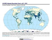
Gridded Population of the World, Version 4 (GPWv4): Population Count Adjusted to Match 2015 Revision of UN WPP Country Totals, Revision 11
National Aeronautics and Space Administration —
The Gridded Population of the World, Version 4 (GPWv4): Population Count Adjusted to Match 2015 Revision of UN WPP Country Totals, Revision 11 consists of estimates... -
Federal
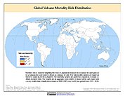
Global Volcano Mortality Risks and Distribution
National Aeronautics and Space Administration —
Global Volcano Mortality Risks and Distribution is a 2.5 minute grid representing global volcano mortality risks. The data set was constructed using historical... -
Federal
Natural Resource Protection and Child Health Indicators, 2013 Release
National Aeronautics and Space Administration —
The Natural Resource Protection and Child Health Indicators, 2013 Release, are produced in support of the U.S. Millennium Challenge Corporation as selection criteria... -
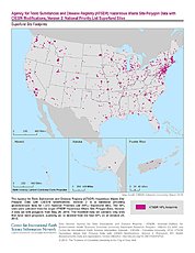
Federal
ATSDR Hazardous Waste Site Polygon Data with CIESIN Modifications, Version 2
National Aeronautics and Space Administration —
The Agency for Toxic Substances and Disease Registry (ATSDR) Hazardous Waste Site Polygon Data with CIESIN Modifications, Version 2 is a database providing... -
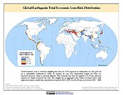
Federal
Global Earthquake Total Economic Loss Risk Deciles
National Aeronautics and Space Administration —
The Global Earthquake Total Economic Loss Risk Deciles is a 2.5 minute grid of global earthquake total economic loss risks. A process of spatially allocating Gross... -
Federal
Compendium of Environmental Sustainability Indicator Collections: 2006 National Footprint Accounts (NFA)
National Aeronautics and Space Administration —
The 2006 National Footprint Accounts (NFA) portion of the Compendium of Environmental Sustainability Indicator Collections, version 1.1 is a data set that measures... -
Federal
Gridded Population of the World, Version 3 (GPWv3): National Identifier Grid
National Aeronautics and Space Administration —
The Gridded Population of the World, Version 3 (GPWv3): National Identifier Grid is derived from the land area grid to create a raster surface where pixels (cells)... -
Federal
IPCC Special Report on Emissions Scenarios (SRES) Fluor-Gases Emissions Dataset
National Aeronautics and Space Administration —
The Intergovernmental Panel on Climate Change (IPCC) Special Report Emissions Scenarios (SRES) Fluor-Gases Emissions Dataset consists of global and regional emissions... -
Federal
Global Volcano Total Economic Loss Risk Deciles
National Aeronautics and Space Administration —
Global Volcano Total Economic Loss Risk Deciles is a 2.5 minute grid of global volcano total economic loss risks. First, subnational distributions of Gross Domestic... -
Federal
Global Rural-Urban Mapping Project, Version 1 (GRUMPv1): Coastlines
National Aeronautics and Space Administration —
The Global Rural-Urban Mapping Project, Version 1 (GRUMPv1): Coastlines data are derived from the land area grids to show the outlines of pixels (cells) that contain... -
Federal
U.S. Population Grids (Summary File 1), 2000: Alabama, Louisiana, Mississippi and Texas, Alpha Version
National Aeronautics and Space Administration —
The U.S. Population Grids (Summary File 1), 2000: Alabama, Louisiana, Mississippi and Texas, Alpha Version data set contains an ARC/INFO Workspace with grids of...

Official websites use .gov
A
.gov website belongs to an official government
organization in the United States.
Secure .gov websites use HTTPS
A
lock (
) or https:// means you’ve safely connected to
the .gov website. Share sensitive information only on official,
secure websites.