
-
Federal
West Africa Coastal Vulnerability Mapping: GPW Version 4 Population Growth, Preliminary Release 1, 2000-2010
National Aeronautics and Space Administration —
The West Africa Coastal Vulnerability Mapping: GPW Version 4 Population Growth, Preliminary Release 1, 2000-2010, represents positive or negative growth in the number... -
Federal
U.S. Census Grids (Summary File 3), 1990
National Aeronautics and Space Administration —
The U.S. Census Grids (Summary File 3), 1990 data set contains grids of demographic and socioeconomic data from the year 1990 U.S. census in ASCII and GeoTIFF... -
Federal
West Africa Coastal Vulnerability Mapping: Point and Gridded Locations of Fatalities, 2008-2013
National Aeronautics and Space Administration —
The West Africa Coastal Vulnerability Mapping: Point and Gridded Locations of Fatalities, 2008-2013 data set consists of two layers: points representing the location... -
Federal
Global Rural-Urban Mapping Project, Version 1 (GRUMPv1): Settlement Points, Revision 01
National Aeronautics and Space Administration —
The Global Rural-Urban Mapping Project, Version 1 (GRUMPv1): Settlement Points, Revision 01 is an updated version of the Settlement Points, Version 1 (v1) used in the... -
Federal
Archive of Census Related Products (ACRP): 1990 SAS Transport Files
National Aeronautics and Space Administration —
The 1990 SAS Transport Files portion of the Archive of Census Related Products (ACRP) contains housing and population data from the U.S. Census Bureau's 1990 Summary... -
Federal
West Africa Coastal Vulnerability Mapping: Deforestation, 2000-2012
National Aeronautics and Space Administration —
The West Africa Coastal Vulnerability Mapping: Deforestation, 2000-2012, layer was created from the Global Forest Change data set which represents global tree cover... -
Federal
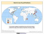
Global Cyclone Hazard Frequency and Distribution
National Aeronautics and Space Administration —
The Global Cyclone Hazard Frequency and Distribution is a 2.5 minute grid based on more than 1,600 storm tracks for the period 1 January 1980 through 31 December 2000... -
Federal
Daily and Annual NO2 Concentrations for the Contiguous United States, 1-km Grids, Version 1.10 (2000-2016)
National Aeronautics and Space Administration —
The Daily and Annual NO2 Concentrations for the Contiguous United States, 1-km Grids, Version 1.10 (2000-2016) data set contains daily predictions of Nitrogen Dioxide... -
Federal
Natural Resource Protection and Child Health Indicators, 2019 Release
National Aeronautics and Space Administration —
The Natural Resource Protection and Child Health Indicators, 2019 Release, is produced in support of the U.S. Millennium Challenge Corporation (MCC) as selection... -
Federal
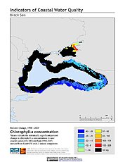
Indicators of Coastal Water Quality: Change in Chlorophyll-a Concentration 1998-2007
National Aeronautics and Space Administration —
The Change in Chlorophyll-a Concentrations 1998-2007 component of the Indicators of Coastal Water Quality Collection represents a tabular time series of the... -
Federal
Natural Resource Protection and Child Health Indicators, 2021 Release
National Aeronautics and Space Administration —
The Natural Resource Protection and Child Health Indicators, 2021 Release, is produced in support of the U.S. Millennium Challenge Corporation (MCC) as selection... -
Federal
Anthropogenic Biomes of the World, Version 2: 1700
National Aeronautics and Space Administration —
The Anthropogenic Biomes of the World, Version 2: 1700 data set describes anthropogenic transformations within the terrestrial biosphere caused by sustained direct... -
Federal
Natural Resource Protection and Child Health Indicators, 2014 Release
National Aeronautics and Space Administration —
The Natural Resource Protection and Child Health Indicators, 2014 Release, are produced in support of the U.S. Millennium Challenge Corporation as selection criteria... -
Federal
Compendium of Environmental Sustainability Indicator Collections: Ancillary Data
National Aeronautics and Space Administration —
The Ancillary Data portion of the Compendium of Environmental Sustainability Indicator Collections contains 38 variables (time series data on population and gross... -
Federal
China Dimensions Data Collection: Agricultural Statistics of the People's Republic of China: 1949-1990
National Aeronautics and Space Administration —
The Agricultural Statistics of the People's Republic of China, 1949-1990 is an historical collection of agricultural statistical data compiled by China's State... -
Federal
U.S. EPA National Priorities List (NPL) Sites Point Data with CIESIN Modifications, Version 2
National Aeronautics and Space Administration —
The U.S. Environmental Protection Agency (EPA) National Priorities List (NPL) Sites Point Data with CIESIN Modifications, Version 2 is a modified version of the 2014... -
Federal
Last of the Wild Project, Version 1, 2002 (LWP-1): Top One Percent Wild Areas Dataset (Geographic)
National Aeronautics and Space Administration —
The Top One Percent Wild Areas Dataset of the Last of the Wild Project, Version 1, 2002 (LWP-1) is derived from the LWP-1 Human Footprint Dataset. The gridded data... -
Federal
Global 1-km Downscaled Population Base Year and Projection Grids Based on the Shared Socioeconomic Pathways, Revision 01
National Aeronautics and Space Administration —
The Global 1-km Downscaled Population Base Year and Projection Grids Based on the Shared Socioeconomic Pathways, Revision 01, data set consists of global urban,... -
Federal
Archive of Census Related Products (ACRP): 1980 SAS Transport Files
National Aeronautics and Space Administration —
The 1980 SAS Transport Files portion of the Archive of Census Related Products (ACRP) contains housing and population demographics from the 1980 Summary Tape File...

Official websites use .gov
A
.gov website belongs to an official government
organization in the United States.
Secure .gov websites use HTTPS
A
lock (
) or https:// means you’ve safely connected to
the .gov website. Share sensitive information only on official,
secure websites.