
-
Federal
PacIOOS Wave Buoy 187: Pauwela, Maui, Hawaii
National Oceanic and Atmospheric Administration, Department of Commerce —
Wave buoy 187 measures wave height, wave direction, wave period, and water temperature in the vicinity of Pauwela and Kahului on the North Shore of Maui in the State... -
Federal
MAPCO2 Buoy: Maihi Bay, Hawaii Island, Hawaii
National Oceanic and Atmospheric Administration, Department of Commerce —
This buoy is located in Maihi Bay approximately 200 meters offshore of the west coast of Hawaii Island just south of Kahaluu-Keauhou in the State of Hawaii. It is... -
Federal
Nutrient and water chemistry data of Aua Reef in American Samoa from samples collected along a water quality gradient between 2022-09-13 to 2022-09-23
National Oceanic and Atmospheric Administration, Department of Commerce —
The data described here are from water samples collected during NOAA Pacific Islands Fisheries Science Center (PIFSC), Ecosystem Sciences Division (ESD) led fly-in... -
Federal
EM300 Multibeam Sonar Data collected from January 26 to April 22 from NOAA Ship Hi'ialakai cruise HA-15-01 to the Pacific Remote Island Areas and American Samoa in 2015
National Oceanic and Atmospheric Administration, Department of Commerce —
Multibeam data were collected using a Simrad EM300 30-kHz sonar aboard NOAA Ship Hi'ialakai, a 68-m (218') NOAA research vessel, from January 26 to April 22, 2015... -
Federal
PacIOOS Nearshore Sensor 010: Maunalua Bay, Oahu, Hawaii
National Oceanic and Atmospheric Administration, Department of Commerce —
The nearshore sensors are part of the Pacific Islands Ocean Observing System (PacIOOS) and are designed to measure a variety of ocean parameters at fixed points.... -
Federal
NEOWAVE Regional Tsunami Model: Kalapana 1975: Hawaii: Maui
National Oceanic and Atmospheric Administration, Department of Commerce —
Non-hydrostatic Evolution of Ocean WAVEs (NEOWAVE) regional tsunami model for Maui County in the State of Hawaii, which includes the islands of Maui, Molokai, Lanai,... -
Federal
H13477: NOS Hydrographic Survey , 2021-10-07
National Oceanic and Atmospheric Administration, Department of Commerce —
The National Oceanic and Atmospheric Administration (NOAA) has the statutory mandate to collect hydrographic data in support of nautical chart compilation for safe... -
Federal
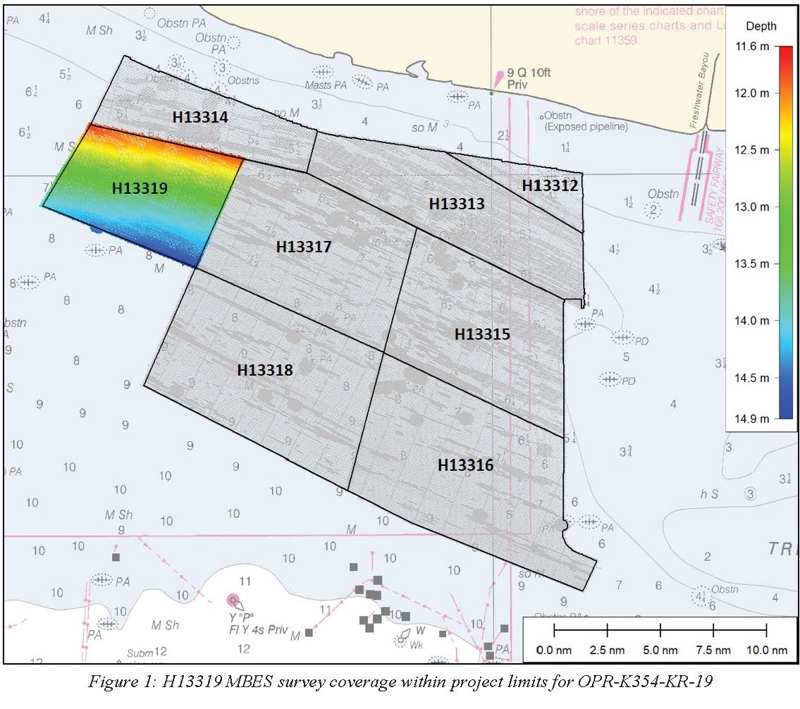
H13319: NOS Hydrographic Survey , 2020-02-23
National Oceanic and Atmospheric Administration, Department of Commerce —
The National Oceanic and Atmospheric Administration (NOAA) has the statutory mandate to collect hydrographic data in support of nautical chart compilation for safe... -
Federal
H13441: NOS Hydrographic Survey , 2021-09-18
National Oceanic and Atmospheric Administration, Department of Commerce —
The National Oceanic and Atmospheric Administration (NOAA) has the statutory mandate to collect hydrographic data in support of nautical chart compilation for safe... -
Federal
H13318: NOS Hydrographic Survey , 2020-03-11
National Oceanic and Atmospheric Administration, Department of Commerce —
The National Oceanic and Atmospheric Administration (NOAA) has the statutory mandate to collect hydrographic data in support of nautical chart compilation for safe... -
Federal
H13304: NOS Hydrographic Survey , 2020-10-22
National Oceanic and Atmospheric Administration, Department of Commerce —
The National Oceanic and Atmospheric Administration (NOAA) has the statutory mandate to collect hydrographic data in support of nautical chart compilation for safe... -
Federal
W00684: NOS Hydrographic Survey , External Source Data 2023, 2022-11-17
National Oceanic and Atmospheric Administration, Department of Commerce —
The National Oceanic and Atmospheric Administration (NOAA) has the statutory mandate to collect hydrographic data in support of nautical chart compilation for safe... -
Federal
H13432: NOS Hydrographic Survey , 2021-06-23
National Oceanic and Atmospheric Administration, Department of Commerce —
The National Oceanic and Atmospheric Administration (NOAA) has the statutory mandate to collect hydrographic data in support of nautical chart compilation for safe... -
Federal
H13285: NOS Hydrographic Survey , 2019-11-26
National Oceanic and Atmospheric Administration, Department of Commerce —
The National Oceanic and Atmospheric Administration (NOAA) has the statutory mandate to collect hydrographic data in support of nautical chart compilation for safe... -
Federal
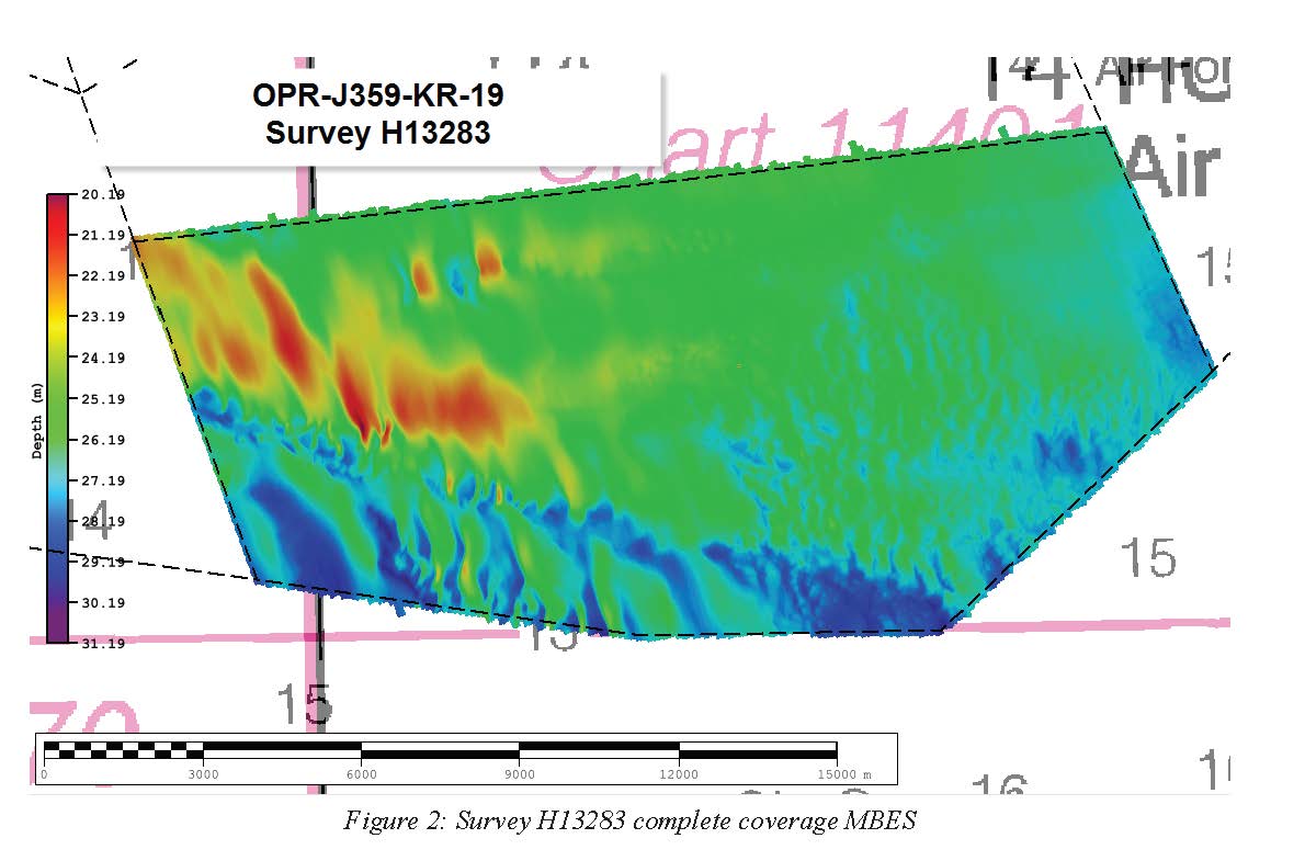
H13283: NOS Hydrographic Survey , 2019-11-26
National Oceanic and Atmospheric Administration, Department of Commerce —
The National Oceanic and Atmospheric Administration (NOAA) has the statutory mandate to collect hydrographic data in support of nautical chart compilation for safe... -
Federal
H13220: NOS Hydrographic Survey , 2019-09-29
National Oceanic and Atmospheric Administration, Department of Commerce —
The National Oceanic and Atmospheric Administration (NOAA) has the statutory mandate to collect hydrographic data in support of nautical chart compilation for safe... -
Federal
H13178: NOS Hydrographic Survey , 2019-07-24
National Oceanic and Atmospheric Administration, Department of Commerce —
The National Oceanic and Atmospheric Administration (NOAA) has the statutory mandate to collect hydrographic data in support of nautical chart compilation for safe... -
Federal
Simulating WAves Nearshore (SWAN) Regional Wave Model: Big Island
National Oceanic and Atmospheric Administration, Department of Commerce —
Simulating WAves Nearshore (SWAN) regional wave model 7-day output with a 5-day hourly forecast for the Big Island of Hawaii at approximately 500-m resolution. This... -
Federal
NEOWAVE Regional Tsunami Model: Kalapana 1975: Hawaii: Kauai
National Oceanic and Atmospheric Administration, Department of Commerce —
Non-hydrostatic Evolution of Ocean WAVEs (NEOWAVE) regional tsunami model for Kauai County in the State of Hawaii, which includes the islands of Kauai and Niihau.... -
Federal
PacIOOS Water Quality Buoy 05: Pelekane Bay, Big Island, Hawaii
National Oceanic and Atmospheric Administration, Department of Commerce —
The water quality buoys are part of the Pacific Islands Ocean Observing System (PacIOOS) and are designed to measure a variety of ocean parameters at fixed points....

Official websites use .gov
A
.gov website belongs to an official government
organization in the United States.
Secure .gov websites use HTTPS
A
lock (
) or https:// means you’ve safely connected to
the .gov website. Share sensitive information only on official,
secure websites.