
-
Federal
Fast Longwave And SHortwave Fluxes (FLASHflux) Clouds and Radiative Swath (SSF) data in netCDF
National Aeronautics and Space Administration —
FLASH_SSF_NOAA20-FM6-VIIRS_Version1A data are near real-time CERES observed TOA fluxes, clouds, and parameterized surface fluxes, not officially calibrated. The Fast... -
Federal
International Comprehensive Ocean Atmosphere Data Set (ICOADS) in Near-Real Time (NRT) Version 2.5 (Version Superseded)
National Oceanic and Atmospheric Administration, Department of Commerce —
Please note, this dataset has been superseded by a newer version (see below). Users should not use this version except in rare cases (e.g., when reproducing... -
Federal
MODIS/Aqua CLD Mask Spect. Results 250m and 1km 5-Min L2 Narrow Swath Subset along CloudSat V002 (MAC35S0) at GES DISC NGDA
National Aeronautics and Space Administration —
This is the narrow-swath MODIS/Aqua subset along CloudSat field of view track. The goal of the narrow-swath subset is to select and return MODIS data that are within... -
Federal
SatCORPS CERES GEO Edition 4 Meteosat-8 Southern Hemisphere Version 1.0
National Aeronautics and Space Administration —
CER_GEO_Ed4_MET08_SH_V01 is the Satellite Cloud and Radiation Property retrieval System (SatCORPS) Clouds and the Earth's Radiant Energy System (CERES) Geostationary... -
Federal
MODIS/Aqua CLD Mask Spect. Results 250m and 1km 5-Min L2 Wide Swath Subset along CloudSat V002 (MAC35S1) at GES DISC NGDA
National Aeronautics and Space Administration —
This is the wide-swath MODIS/Aqua subset along CloudSat field of view track. The goal of the wide-swath subset is to select and return MODIS data that are within... -
Federal
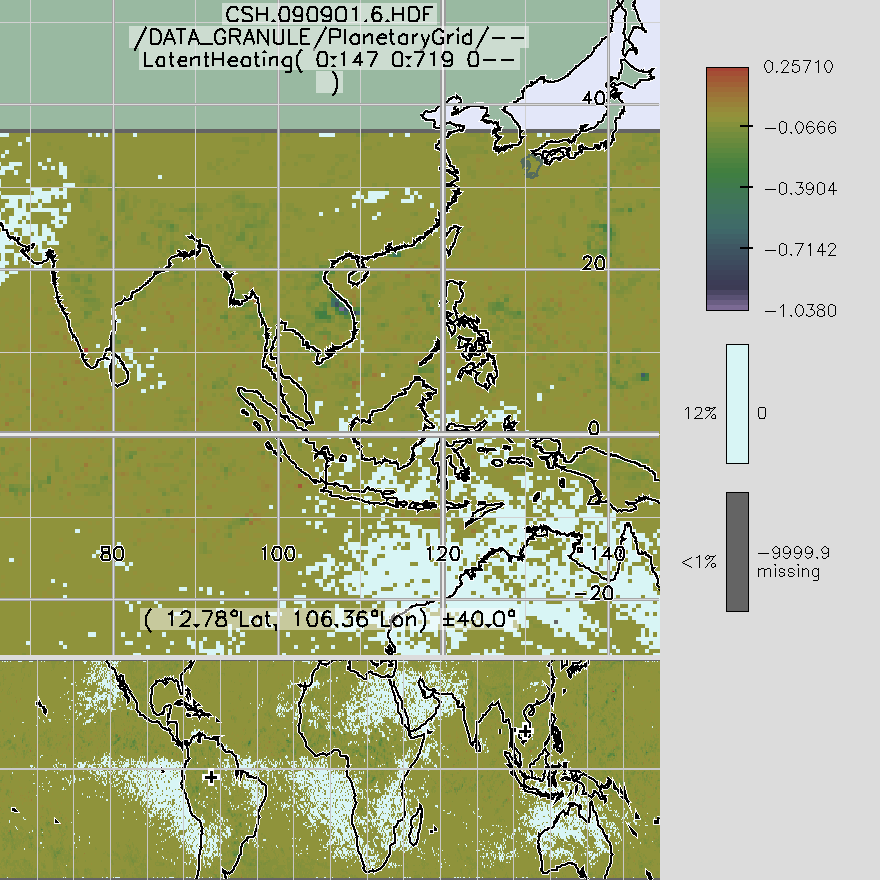
TRMM Convective and Stratiform Heating L3 1 month 0.5 degree x 0.5 degree V6 (TRMM_CSH) at GES DISC
National Aeronautics and Space Administration —
These data are output from the Goddard Convective-Stratiform Heating (CSH) algorithm. The dataset contains global 0.5 x 0.5 monthly latent heating profiles from... -
Federal
AMSR-E/Aqua L2B Global Swath Surface Precipitation GSFC Profiling Algorithm V004
National Aeronautics and Space Administration —
The AMSR-E/Aqua Level-2B precipitation product includes instantaneous surface precipitation rate and type over ice-free/snow-free land and ocean between 89.24 degrees... -
Federal
Cloudmask, CLAVR-1, NOAA POES AVHRR, 0.0125 degrees, West US, 2007-present, Nighttime (Single Scan)
National Oceanic and Atmospheric Administration, Department of Commerce —
The CLAVR-1 cloudmask (Stowe, 1999) is used to cloudmask AVHRR high resolution sea surface temperature products. The cloudmask runs a series of tests on each surface... -
Federal
TES/Aura L2 Ammonia Nadir V007
National Aeronautics and Space Administration —
TL2NH3N_7 is the Tropospheric Emission Spectrometer (TES)/Aura Level 2 Ammonia Nadir Version 7 data product. TES was an instrument aboard NASA's Aura satellite and... -
Federal
AERONET Level 2.0 AOD
National Aeronautics and Space Administration —
The aerosol optical depth processing includes the spectral de-convolution algorithm (SDA) described in O'Neill et al. (2003). This algorithm yields fine (sub-micron)... -
Federal
SBU Parsivel IMPACTS V1
National Aeronautics and Space Administration —
The SBU Parsivel IMPACTS dataset consists of precipitation data collected by the Parsivel disdrometer in support of the Investigation of Microphysics and... -
Federal
AMSR-E/Aqua L2B Global Swath Ocean Products derived from Wentz Algorithm V002
National Aeronautics and Space Administration —
This daily Level-2B swath data set includes Sea Surface Temperature (SST), Near-Surface Wind Speed, Columnar Water Vapor, and Cloud liquid Water data arrays, and was... -
Federal
TOVS LMD MONTHLY GRIDS from NOAA-10 V01 (TOVSBMNG) at GES DISC
National Aeronautics and Space Administration —
Level 3 parameters from HIRS/2 and MSU radiances using the Improved Initialization Inversion (3I) classification retrieval scheme by the Laboratoire de Meteorologie... -
Federal
SWOT Level 2 Radiometer Brightness Temperatures and Troposphere Interim Data Product, Version 2.0
National Aeronautics and Space Administration —
The SWOT Level 2 Radiometer Brightness Temperatures and Troposphere Interim Geophysical Data Record (IGDR) Version 1.0 dataset produced by the Surface Water and Ocean... -
Federal
NOAA GOES-R Series Advanced Baseline Imager (ABI) Level 2 Cloud Cover Layers (CCL)
National Oceanic and Atmospheric Administration, Department of Commerce —
The GOES-R Advanced Baseline Imager (ABI) Cloud Cover Layers (CCL) product contains estimates of cloud fraction between predefined atmospheric levels, as well as, the... -
Federal
TES/Aura L2 Carbon Dioxide Nadir Special Observation V007
National Aeronautics and Space Administration —
TL2CO2NS_7 is the Tropospheric Emission Spectrometer (TES)/Aura Level 2 Carbon Dioxide Nadir Special Observation Version 7 data product. TES Level 2 data contain... -
Federal
TES/Aura L2 Formic Acid Nadir Special Observation V007
National Aeronautics and Space Administration —
TL2FORNS_7 is the Tropospheric Emission Spectrometer (TES)/Aura Level 2 Formic Acid Nadir Special Observation Version 7 data product. It consists of information for... -
Federal
Sentinel-5P TROPOMI SNPP VIIRS cloud product band 3 (UVIS detector) 1-Orbit L2 5.5km x 3.5km V2 (S5P_L2__NP_BD3_HiR) at GES DISC
National Aeronautics and Space Administration —
Starting from August 6th in 2019, Sentinel-5P TROPOMI along-track high spatial resolution (~5.5km at nadir) has been implemented. For data before August 6th of 2019,... -
Federal
AMSR-E/Aqua Weekly L3 Global Ascending/Descending .25x.25 deg Ocean Grids V002
National Aeronautics and Space Administration —
The Level-3 daily product (AE_DyOcn), weekly product (AE_WkOcn), and monthly product (AE_MoOcn) include SST, near-surface wind speed, columnar water vapor, and... -
Federal
Sentinel-5P TROPOMI SNPP VIIRS cloud product band 6 (NIR detector) 1-Orbit L2 5.5km x 3.5km V2 (S5P_L2__NP_BD6_HiR) at GES DISC
National Aeronautics and Space Administration —
Starting from August 6th in 2019, Sentinel-5P TROPOMI along-track high spatial resolution (~5.5km at nadir) has been implemented. For data before August 6th of 2019,...

Official websites use .gov
A
.gov website belongs to an official government
organization in the United States.
Secure .gov websites use HTTPS
A
lock (
) or https:// means you’ve safely connected to
the .gov website. Share sensitive information only on official,
secure websites.