
-
Federal
F00292: NOS Hydrographic Survey , Seymour Canal, Alaska, 1986-11-09 recent views
National Oceanic and Atmospheric Administration, Department of Commerce —
The National Oceanic and Atmospheric Administration (NOAA) has the statutory mandate to collect hydrographic data in support of nautical chart compilation for safe... -
Federal
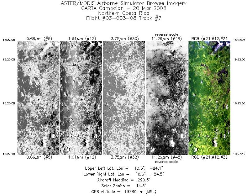
MASTER: Costa Rica Airborne Research and Technology Applications, March, 2003 recent views
National Aeronautics and Space Administration —
This dataset includes Level 1B (L1B) data products from the MODIS/ASTER Airborne Simulator (MASTER) instrument. The spectral data were collected during 14 flights... -
Federal
F00023: NOS Hydrographic Survey , 1940-07-02 recent views
National Oceanic and Atmospheric Administration, Department of Commerce —
The National Oceanic and Atmospheric Administration (NOAA) has the statutory mandate to collect hydrographic data in support of nautical chart compilation for safe... -
Federal
ECCO Sea-Ice Velocity - Daily Mean 0.5 Degree (Version 4 Release 4) recent views
National Aeronautics and Space Administration —
This dataset contains daily-averaged sea-ice velocity interpolated to a regular 0.5-degree grid from the ECCO Version 4 revision 4 (V4r4) ocean and sea-ice state... -
Federal
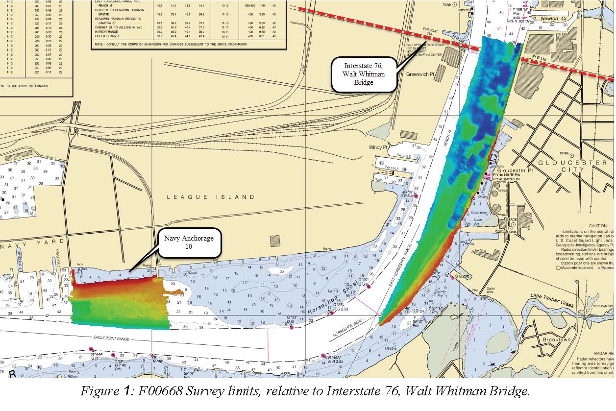
F00668: NOS Hydrographic Survey , 2015-10-22 recent views
National Oceanic and Atmospheric Administration, Department of Commerce —
The National Oceanic and Atmospheric Administration (NOAA) has the statutory mandate to collect hydrographic data in support of nautical chart compilation for safe... -
Federal
H10188: NOS Hydrographic Survey , Togiak Bay, Alaska, 1985-08-05 recent views
National Oceanic and Atmospheric Administration, Department of Commerce —
The National Oceanic and Atmospheric Administration (NOAA) has the statutory mandate to collect hydrographic data in support of nautical chart compilation for safe... -
Federal
ECCO Atmosphere Surface Temperature, Humidity, Wind, and Pressure - Monthly Mean llc90 Grid (Version 4 Release 4) recent views
National Aeronautics and Space Administration —
This dataset provides monthly-averaged atmosphere surface temperature, humidity, winds, and pressure on the native Lat-Lon-Cap 90 (LLC90) model grid from the ECCO... -
Federal
ECCO Sea-Ice and Snow Concentration and Thickness - Monthly Mean 0.5 Degree (Version 4 Release 4) recent views
National Aeronautics and Space Administration —
This dataset contains monthly-averaged sea-ice and snow concentration and thickness interpolated to a regular 0.5-degree grid from the ECCO Version 4 revision 4... -
Federal
H13372: NOS Hydrographic Survey , 2020-09-16 recent views
National Oceanic and Atmospheric Administration, Department of Commerce —
The National Oceanic and Atmospheric Administration (NOAA) has the statutory mandate to collect hydrographic data in support of nautical chart compilation for safe... -
Federal
ECCO Ocean 3D Gent-Mcwilliams, Redi, and Background Vertical Diffusivity Coefficients for the 0.5 degree Lat-Lon Model Grid (Version 4 Release 4) recent views
National Aeronautics and Space Administration —
This dataset provides 3D coefficients for the Gent-McWilliams and Redi parameterizations and background vertical diffusivity interpolated to a regular 0.5-degree grid... -
Federal
ABoVE: Wetland Vegetation Classification for Peace-Athabasca Delta, Canada, 2019 recent views
National Aeronautics and Space Administration —
This dataset contains land cover classification focused on water and wetland vegetation communities over the Peace-Athabasca Delta, Canada. Four classification maps... -
Federal
Greenness Trends and Carbon Stocks of Mangrove Forests Across Mexico, 2001-2015 NGDA recent views
National Aeronautics and Space Administration —
This dataset provides estimates of greenness trends, above- and belowground carbon stocks, and climate variables of the persistent mangrove forests on the coasts of... -
Federal
Global Gridded Surfaces of Selected Soil Characteristics (IGBP-DIS) recent views
National Aeronautics and Space Administration —
Global data-surfaces pre-generated by SoilData, at a resolution of 5x5 arc-minutes, in ASCII GRID format for ARC INFO, and for the soil depth interval 0-100 cm. -
Federal
MODIS Aqua Level 3 SST Thermal IR Daily 9km Daytime V2019.0 NGDA recent views
National Aeronautics and Space Administration —
Day and night spatially gridded (L3) global NASA skin sea surface temperature (SST) products from the Moderate-resolution Imaging Spectroradiometer (MODIS) onboard... -
Federal
H13183: NOS Hydrographic Survey , 2019-02-06 recent views
National Oceanic and Atmospheric Administration, Department of Commerce —
The National Oceanic and Atmospheric Administration (NOAA) has the statutory mandate to collect hydrographic data in support of nautical chart compilation for safe... -
Federal
SWOT Simulated Level-2 Nadir SSH from MITgcm ECCO LLC4320 for Cal/Val Version 1 recent views
National Aeronautics and Space Administration —
This dataset provides simulated sea surface height (SSH) in a format similar to the future SWOT Level 2 (L2) altimetry data stream from the Poseidon 3C nadir... -
Federal
ECCO Sea-Ice and Snow Concentration and Thickness - Snapshot llc90 Grid (Version 4 Release 4) recent views
National Aeronautics and Space Administration —
This dataset provides instantaneous sea-ice and snow concentration, thickness, and pressure loading on the native Lat-Lon-Cap 90 (LLC90) model grid from the ECCO... -
Federal
MetOp-C ASCAT Level 2 25.0km Ocean Surface Wind Vectors in Full Orbit Swath recent views
National Aeronautics and Space Administration —
This dataset contains operational near-real-time Level 2 ocean surface wind vector retrievals from the Advanced Scatterometer (ASCAT) on MetOp-C at 25 km sampling... -
Federal
ECCO Sea-Ice Salt Plume Fluxes - Daily Mean llc90 Grid (Version 4 Release 4) recent views
National Aeronautics and Space Administration —
This dataset provides daily-averaged sea-ice salt plume fluxes on the native Lat-Lon-Cap 90 (LLC90) model grid from the ECCO Version 4 Release 4 (V4r4) ocean and sea-... -
Federal
H12884: NOS Hydrographic Survey , 2016-09-29 recent views
National Oceanic and Atmospheric Administration, Department of Commerce —
The National Oceanic and Atmospheric Administration (NOAA) has the statutory mandate to collect hydrographic data in support of nautical chart compilation for safe...

Official websites use .gov
A
.gov website belongs to an official government
organization in the United States.
Secure .gov websites use HTTPS
A
lock (
) or https:// means you’ve safely connected to
the .gov website. Share sensitive information only on official,
secure websites.
.jpg)
.jpg)