
-
Federal
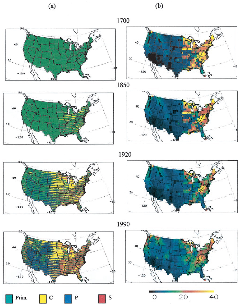
Ecosystem Demography Model: U.S. Ecosystem Carbon Stocks and Fluxes, 1700-1990
National Aeronautics and Space Administration —
This model product contains the source code for the Ecosystem Demography Model (ED version 1.0) as well as model input and output data files for the conterminous... -
State
Killdeer Range - CWHR B158 [ds1462]
State of California —
Vector datasets of CWHR range maps are one component of California Wildlife Habitat Relationships (CWHR), a comprehensive information system and predictive model for... -
Federal
Risk Factor Analysis in Low-Temperature Geothermal Play Fairway Analysis for the Appalachian Basin (GPFA-AB)
Department of Energy —
This submission contains information used to compute the risk factors for the GPFA-AB project. The risk factors are natural reservoir quality, thermal resource... -
Federal
BOREAS RSS-04 1994 Jack Pine Leaf Biochemistry and Modeled Spectra in the SSA
National Aeronautics and Space Administration —
The BOREAS RSS-04 team focused its efforts on deriving estimates of LAI and leaf chlorophyll and nitrogen concentrations from remotely sensed data for input into the... -
Federal
BDSNP Module for Improved Soil NO Emission Estimates for CMAQ Model, Conterminous USA
National Aeronautics and Space Administration —
This model product provides: (1) the source code for the updated Berkeley-Dalhousie Soil Nitric Oxide (NO) Parameterization module (BDSNP, Version 1.0) as implemented... -
University
EMPLOY OCC Civilian Females 16 Yrs and Over by Occupation CTs 2000
Earth Data Analysis Center, University of New Mexico —
TIGER, TIGER/Line, and Census TIGER are registered trademarks of the Bureau of the Census. The Redistricting Census 2000 TIGER/Line files are an extract of selected... -
Federal
LBA-ECO CD-04 LAI Estimated from Photos, km 83 Tower Site, Tapajos National Forest
National Aeronautics and Space Administration —
This data set contains summary data for monthly leaf area index (LAI) and plant area index (PAI) at the km 83 Tower Site, in the Tapajos National Forest, Para,... -
Federal
Land Surface Model (LSM 1.0) for Ecological, Hydrological, Atmospheric Studies
National Aeronautics and Space Administration —
The NCAR LSM 1.0 is a land surface model developed by Gordon Bonan to examine biogeophysical and biogeochemical land-atmosphere interactions, especially the effects... -
University
2010, Mora County, NM, Linear Hydrography
Earth Data Analysis Center, University of New Mexico —
The TIGER/Line Files are shapefiles and related database files (.dbf) that are an extract of selected geographic and cartographic information from the U.S. Census... -
University
2000 Census 5-Digit ZIP Code Tabulation Areas (ZCTAs) for Catron County, New Mexico, 2006se TIGER
Earth Data Analysis Center, University of New Mexico —
The 2006 Second Edition TIGER/Line files are an extract of selected geographic and cartographic information from the Census TIGER database. The geographic coverage... -
Federal
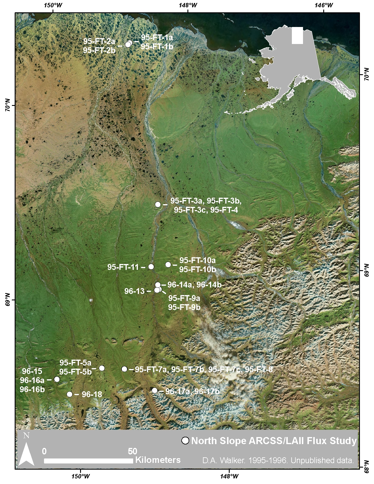
Arctic Vegetation Plots at ARCSS/LAII Flux Sites, North Slope, Alaska, 1995-1996
National Aeronautics and Space Administration —
This dataset provides vegetation cover and environmental plot and soil data collected at flux tower sites of the North Slope Arctic System Science/Land-Atmosphere-Ice... -
University
Santa Fe County 2000 Census Block Groups
Earth Data Analysis Center, University of New Mexico —
TIGER, TIGER/Line, and Census TIGER are registered trademarks of the Bureau of the Census. The Redistricting Census 2000 TIGER/Line files are an extract of selected... -
Federal
SORCE XPS Level 4 Solar Spectral Irradiance 0.1nm Res 5-Minute V012 (SOR4XPS5) at GES DISC
National Aeronautics and Space Administration —
The SORCE XPS Level 4 Solar Spectral Irradiance 0.1nm Res 5-Minute product (SOR4XPS5) contains modelled spectral extreme ultraviolet (XUV) irradiances based on... -
University
Hobbs 1:100000 Quad Transportation DLGs
Earth Data Analysis Center, University of New Mexico —
Digital line graph (DLG) data are digital representations of cartographic information. DLG's of map features are converted to digital form from maps and related... -
State
MD iMAP: Maryland Archived American Community Survey Census Tracts 2009 to 2013
State of Maryland —
This is a MD iMAP hosted service. Find more information on http://imap.maryland.gov. The American Community Survey (ACS) is a nationwide - continuous survey designed... -
Federal
School Neighborhood Poverty Estimates, 2018-19
Department of Education —
The 2018-2019 School Neighborhood Poverty Estimates are based on school locations from the 2018-2019 Common Core of Data (CCD) school file and income data from... -
University
Sierra County TIGER 2000 Hydrography and Nodes
Earth Data Analysis Center, University of New Mexico —
TIGER, TIGER/Line, and Census TIGER are registered trademarks of the Bureau of the Census. The Redistricting Census 2000 TIGER/Line files are an extract of selected... -
Federal
Data and code from: Stem borer herbivory dependent on interactions of sugarcane variety, associated traits, and presence of prior borer damage
Department of Agriculture —
This dataset contains all the data and code needed to reproduce the analyses in the manuscript: Penn, H. J., & Read, Q. D. (2023). Stem borer herbivory dependent... -
State
Pre-2012 Primary Care Clinic Utilization Data
State of California —
The complete data set of annual utilization data reported by primary care clinics contains basic clinic identification information including community services,... -
University
Vaughn 1:100000 Quad Hydrography DLGs
Earth Data Analysis Center, University of New Mexico —
Digital line graph (DLG) data are digital representations of cartographic information. DLG's of map features are converted to digital form from maps and related...

Official websites use .gov
A
.gov website belongs to an official government
organization in the United States.
Secure .gov websites use HTTPS
A
lock (
) or https:// means you’ve safely connected to
the .gov website. Share sensitive information only on official,
secure websites.