
-
Federal
NACP North American Forest Dynamics Project: Forest Disturbance and Regrowth Data recent views
National Aeronautics and Space Administration —
This data set provides the results of time-series analyses of Landsat imagery for 55 selected forested sites across the conterminous U.S.A. The output is a pair of... -
Federal
VEMAP 2: Annual Ecosystem Model Responses to U.S. Climate Change, 1994-2100 recent views
National Aeronautics and Space Administration —
Phase 2 of the VEMAP Project developed historical (1895-1993) gridded data sets of climate (temperature, precipitation, solar radiation, humidity, and wind speed) and... -
Federal
ISLSCP II Ecosystem Rooting Depths NGDA recent views
National Aeronautics and Space Administration —
The goal of this study was to predict the global distribution of plant rooting depths based on data about global aboveground vegetation structure and climate.... -
Federal
LBA-ECO LC-08 Soil, Vegetation, and Land Cover Maps for Brazil and South America recent views
National Aeronautics and Space Administration —
This data set provides (1) soil maps for Brazil that are digital versions of the MAPA DE SOLOS DO BRASIL (EMBRAPA, 1981) classified at three levels of detail,... -
Federal
SAR Subsets for Selected Field Sites, 2007-2010 recent views
National Aeronautics and Space Administration —
This data set provides Synthetic Aperture Radar (SAR) images for 42 selected sites from various terrestrial ecology and meteorological monitoring networks including... -
Federal
MODIS-derived Vegetation and Albedo Parameters for Agroecosystem-Climate Modeling NGDA recent views
National Aeronautics and Space Administration —
This dataset provides MODIS-derived leaf area index (LAI), stem area index (SAI), vegetation area fraction, dominant landcover category, and albedo parameters for the... -
Federal
Sentinel-1 Interferograms - Unwrapped Phase (BETA) recent views
National Aeronautics and Space Administration —
Sentinel-1 SLC interferometric products generated by JPL using ISCE v2.0.0, delivered by ASF -
Federal
NACP Integrated Wildland and Cropland 30-m Fuel Characteristics Map, U.S.A., 2010 recent views
National Aeronautics and Space Administration —
The data set provides a 30-m comprehensive fuelbed characteristics map for both the wildland and cropland areas of the conterminous United States (CONUS) for 2010.... -
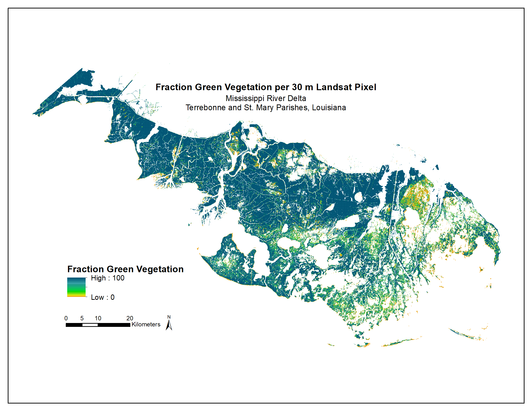
Federal
Green Vegetation Fraction High-Resolution Maps for Selected US Tidal Marshes, 2015 recent views
National Aeronautics and Space Administration —
This dataset provides 30m resolution maps of the fraction of green vegetation within tidal marshes for six estuarine regions of the conterminous United States: Cape... -
Federal
Delta-X AVIRIS-NG L3 Derived Vegetation Types, MRD, Louisiana, USA recent views
National Aeronautics and Space Administration —
This dataset provides maps of vegetation types for the Atchafalaya and Terrebonne basins in coastal Louisiana, U.S., derived from NASA's Next Generation Airborne... -
Federal
Land Cover and Vegetation Map, Arctic National Wildlife Refuge recent views
National Aeronautics and Space Administration —
This data set provides a landcover map with 16 landcover classes for the northern coastal plain of the the Arctic National Wildlife Refuge (ANWR) on the North Slope... -
Federal
ABoVE: Wetland Type, Slave River and Peace-Athabasca Deltas, Canada, 2007 and 2017 recent views
National Aeronautics and Space Administration —
This dataset provides ecosystem-types for the Slave River Delta (SRD) and Peace-Athabasca Delta (PAD), Canada, for the time periods circa 2007 and circa 2017. The... -
Federal
NACP MsTMIP: Global and North American Driver Data for Multi-Model Intercomparison recent views
National Aeronautics and Space Administration —
This data set provides environmental data that have been standardized and aggregated for use as input to carbon cycle models at global (0.5-degree resolution) and... -
Federal
RLC Generalized Forest Map of the Former Soviet Union, 1-km recent views
National Aeronautics and Space Administration —
This data set is the Former Soviet Union (FSU) portion of the Generalized World Forest Map (WCMC, 1998), a 1-kilometer resolution generalized forest cover map for the... -
Federal
ISLSCP II Historical Croplands Cover, 1700-1992 NGDA recent views
National Aeronautics and Space Administration —
The Historical Croplands Cover data set was developed to understand the consequences of historical changes in land use and land cover for ecosystem goods and... -
Federal
Global Monthly GPP from an Improved Light Use Efficiency Model, 1982-2016 recent views
National Aeronautics and Space Administration —
This dataset provides global monthly average gross primary productivity (GPP; g carbon/m2/d) modeled at 8 km spatial resolution for each of the 35 years from... -
Federal
ABoVE: Ecosystem Map, Great Slave Lake Area, Northwest Territories, Canada, 1997-2011 recent views
National Aeronautics and Space Administration —
This dataset provides an ecosystem type map at 12.5 meter pixel spacing and 0.2 ha minimum mapping unit for the area surrounding Great Slave Lake, Northwest... -
Federal
ISLSCP II C4 Vegetation Percentage NGDA recent views
National Aeronautics and Space Administration —
The photosynthetic composition (C3 or C4) of vegetation on the land surface is essential for accurate simulations of biosphere-atmosphere exchanges of carbon, water,... -
Federal
Land Cover and Vegetation Map Collection for Seward Peninsula, Alaska recent views
National Aeronautics and Space Administration —
This data set provides two landcover and vegetation maps for the Seward Peninsula, Alaska. These maps were produced from existing maps, Landsat imagery, and color... -
Federal
Sentinel-1 Interferograms - Coherence (BETA) recent views
National Aeronautics and Space Administration —
Sentinel-1 SLC interferometric products generated by JPL using ISCE v2.0.0, delivered by ASF

Official websites use .gov
A
.gov website belongs to an official government
organization in the United States.
Secure .gov websites use HTTPS
A
lock (
) or https:// means you’ve safely connected to
the .gov website. Share sensitive information only on official,
secure websites.