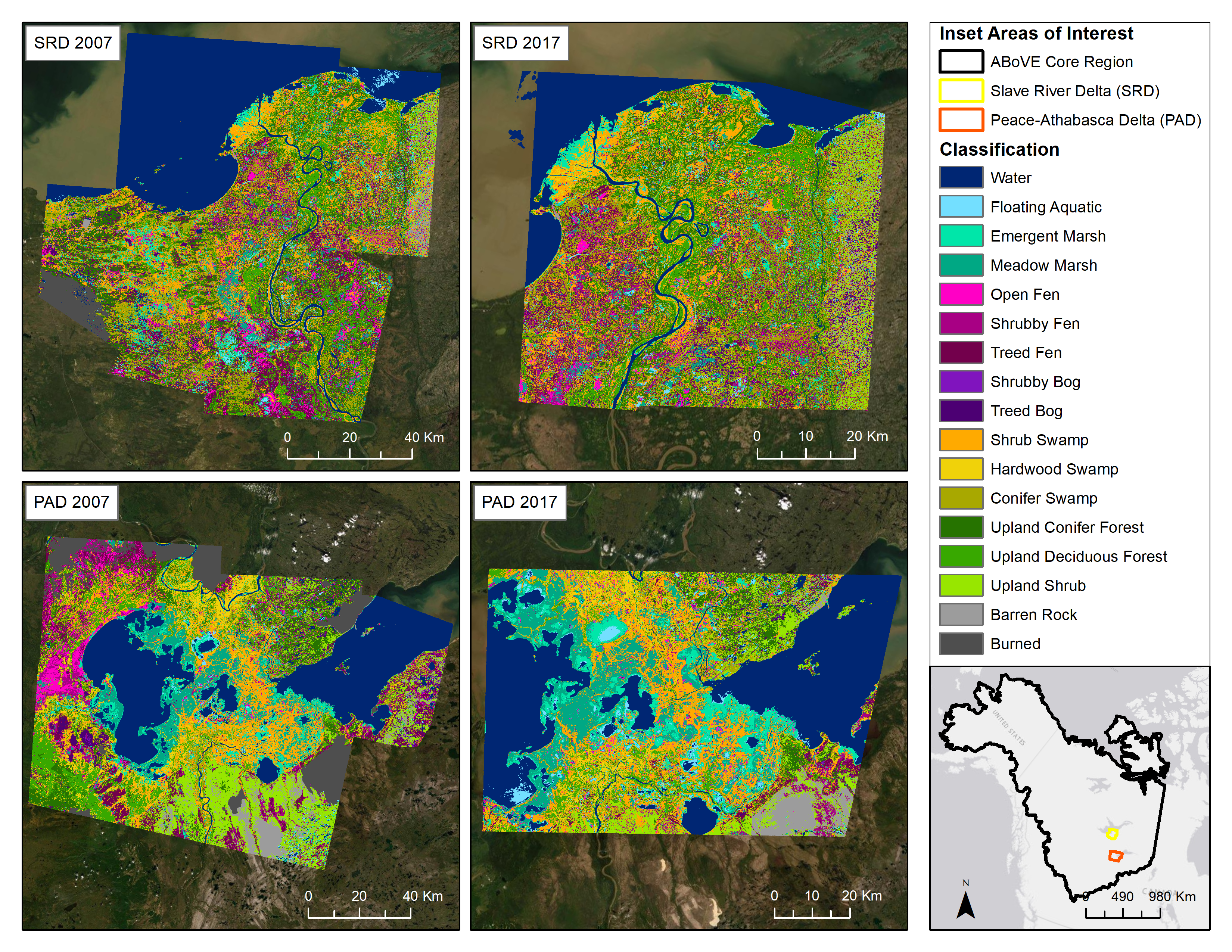
ABoVE: Wetland Type, Slave River and Peace-Athabasca Deltas, Canada, 2007 and 2017
Access & Use Information
Downloads & Resources
-
Google Scholar search resultsHTML
Search results for publications that cite this dataset by its DOI.
-
Download this datasetHTML
This link allows direct data access via Earthdata login
-
View documentation related to this datasetHTML
ORNL DAAC Data Set Documentation
-
This dataset's landing pageHTML
Data set Landing Page DOI URL
-
View documentation related to this datasetPDF
ABoVE: Wetland Type, Slave River and Peace-Athabasca Deltas, Canada, 2007 and...
-
View documentation related to this datasetCSV
ABoVE: Wetland Type, Slave River and Peace-Athabasca Deltas, Canada, 2007 and...
-
View documentation related to this datasetCSV
ABoVE: Wetland Type, Slave River and Peace-Athabasca Deltas, Canada, 2007 and...
-
View documentation related to this datasetCSV
ABoVE: Wetland Type, Slave River and Peace-Athabasca Deltas, Canada, 2007 and...
-
View documentation related to this datasetCSV
ABoVE: Wetland Type, Slave River and Peace-Athabasca Deltas, Canada, 2007 and...
-
View documentation related to this datasetCSV
ABoVE: Wetland Type, Slave River and Peace-Athabasca Deltas, Canada, 2007 and...
-
View documentation related to this datasetCSV
ABoVE: Wetland Type, Slave River and Peace-Athabasca Deltas, Canada, 2007 and...
-
Get a related visualizationPNG
Classified wetland type maps for the Slave River Delta (SRD) and Peace-...
-
The dataset's project home pageHTML
ABoVE project site
-
Landing PageLanding Page
Dates
| Metadata Created Date | December 1, 2022 |
|---|---|
| Metadata Updated Date | December 6, 2023 |
Metadata Source
- Data.json Data.json Metadata
Harvested from NASA Data.json
Graphic Preview

Additional Metadata
| Resource Type | Dataset |
|---|---|
| Metadata Created Date | December 1, 2022 |
| Metadata Updated Date | December 6, 2023 |
| Publisher | ORNL_DAAC |
| Maintainer | |
| Identifier | C2240727799-ORNL_CLOUD |
| Data First Published | 2022-03-21 |
| Language | en-US |
| Data Last Modified | 2023-06-12 |
| Category | ABoVE, geospatial |
| Public Access Level | public |
| Bureau Code | 026:00 |
| Metadata Context | https://project-open-data.cio.gov/v1.1/schema/catalog.jsonld |
| Metadata Catalog ID | https://data.nasa.gov/data.json |
| Schema Version | https://project-open-data.cio.gov/v1.1/schema |
| Catalog Describedby | https://project-open-data.cio.gov/v1.1/schema/catalog.json |
| Citation | French, N.H.F., J.A. Graham, D.J.L. Vander Bilt, L.K. Jenkins, M.J. Battaglia, and L.L. Bourgeau-Chavez. 2022. ABoVE: Wetland Type, Slave River and Peace-Athabasca Deltas, Canada, 2007 and 2017. ORNL DAAC, Oak Ridge, Tennessee, USA. https://doi.org/10.3334/ORNLDAAC/1947 |
| Graphic Preview Description | Classified wetland type maps for the Slave River Delta (SRD) and Peace-Athabasca Delta (PAD), Canada circa 2007 and circa 2017. |
| Graphic Preview File | https://daac.ornl.gov/ABOVE/guides/Ecosystem_Map_SRD_PAD_Fig1.png |
| Harvest Object Id | 919dea05-e0d1-4a04-92e5-3a40a49a9ae8 |
| Harvest Source Id | 58f92550-7a01-4f00-b1b2-8dc953bd598f |
| Harvest Source Title | NASA Data.json |
| Homepage URL | https://doi.org/10.3334/ORNLDAAC/1947 |
| Metadata Type | geospatial |
| Old Spatial | -115.29 57.77 -109.64 61.79 |
| Program Code | 026:001 |
| Source Datajson Identifier | True |
| Source Hash | 2e188af63547264b7796b9294dc320e7ccf427ea391f1e66a8ec2d1ca4a36ba3 |
| Source Schema Version | 1.1 |
| Spatial | |
| Temporal | 2006-06-14T00:00:00Z/2019-05-28T23:59:59Z |
Didn't find what you're looking for? Suggest a dataset here.

