
-
Federal
U.S. Hourly Precipitation Data recent views
National Oceanic and Atmospheric Administration, Department of Commerce —
Hourly Precipitation Data (HPD) is digital data set DSI-3240, archived at the National Climatic Data Center (NCDC). The primary source of data for this file is... -
Federal
U.S. Daily Climate Normals (1981-2010) recent views
National Oceanic and Atmospheric Administration, Department of Commerce —
The U.S. Daily Climate Normals for 1981 to 2010 are 30-year averages of meteorological parameters for thousands of U.S. stations located across the 50 states, as well... -
Federal
NCDC Storm Events Database recent views
National Oceanic and Atmospheric Administration, Department of Commerce —
Storm Data is provided by the National Weather Service (NWS) and contain statistics on personal injuries and damage estimates. Storm Data covers the United States of... -
Federal
Global Historical Climatology Network - Daily (GHCN-Daily), Version 3 recent views
National Oceanic and Atmospheric Administration, Department of Commerce —
The Global Historical Climatology Network - Daily (GHCN-Daily) dataset integrates daily climate observations from approximately 30 different data sources. Version 3... -
Federal
U.S. Local Climatological Data (LCD) recent views
National Oceanic and Atmospheric Administration, Department of Commerce —
Local Climatological Data (LCD) are summaries of climatological conditions from airport and other prominent weather stations managed by NWS, FAA, and DOD. The product... -
Federal
Integrated Surface Dataset (Global) (Version Superseded) recent views
National Oceanic and Atmospheric Administration, Department of Commerce —
This version has been superseded by a newer version. It is highly recommended for users to access the current version. Users should only access this superseded... -
Federal
NOAA NEXt-Generation RADar (NEXRAD) Products NGDA recent views
National Oceanic and Atmospheric Administration, Department of Commerce —
This dataset consists of Level III weather radar products collected from Next-Generation Radar (NEXRAD) stations located in the contiguous United States, Alaska,... -
Federal
U.S. Annual/Seasonal Climate Normals (1981-2010) recent views
National Oceanic and Atmospheric Administration, Department of Commerce —
The U.S. Annual Climate Normals for 1981 to 2010 are 30-year averages of meteorological parameters that provide users with many tools to understand typical climate... -
Federal
U.S. 15 Minute Precipitation Data recent views
National Oceanic and Atmospheric Administration, Department of Commerce —
U.S. 15 Minute Precipitation Data is digital data set DSI-3260, archived at the National Climatic Data Center (NCDC). This is precipitation data. The primary source... -
Federal
U.S. Monthly Climate Normals (1981-2010) recent views
National Oceanic and Atmospheric Administration, Department of Commerce —
The U.S. Monthly Climate Normals for 1981 to 2010 are 30-year averages of meteorological parameters for thousands of U.S. stations located across the 50 states, as... -
Federal
ETOPO 2022 15 Arc-Second Global Relief Model recent views
National Oceanic and Atmospheric Administration, Department of Commerce —
ETOPO 2022, a global relief model with 15 arc-second resolution seamlessly integrating topographic and bathymetric data. The ETOPO 2022 model uses a combination of... -
Federal
NCDC International Best Track Archive for Climate Stewardship (IBTrACS) Project, Version 3 recent views
National Oceanic and Atmospheric Administration, Department of Commerce —
The International Best Track Archive for Climate Stewardship (IBTrACS) dataset was developed by the NOAA National Climatic Data Center, which took the initial step of... -
Federal
Continental United States Hurricane Strikes Since 1950 recent views
National Oceanic and Atmospheric Administration, Department of Commerce —
This is an annual edition poster showing all of the hurricanes having impacted the continental U.S. from 1950 to 2022. This 36x28 inch glossy poster gives a quick... -
Federal
Historical Land-Cover Change and Land-Use Conversions Global Dataset recent views
National Oceanic and Atmospheric Administration, Department of Commerce —
A set of three estimates of land-cover types and annual transformations of land use are provided on a global 0.5 x0.5 degree lat/lon grid at annual time steps. The... -
Federal
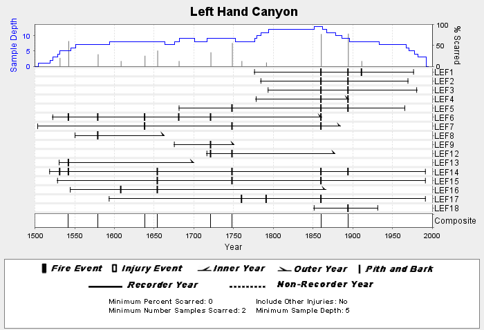
NOAA/WDS Paleoclimatology - Brown fire data from Left Hand Canyon - IMPD USLEF001 recent views
National Oceanic and Atmospheric Administration, Department of Commerce —
This archived Paleoclimatology Study is available from the NOAA National Centers for Environmental Information (NCEI), under the World Data Service (WDS) for... -
Federal
ETOPO1 1 Arc-Minute Global Relief Model recent views
National Oceanic and Atmospheric Administration, Department of Commerce —
In August 2008, the National Geophysical Data Center (NGDC), an office of the National Oceanic and Atmospheric Administration (NOAA), developed the ETOPO1 Global... -
Federal
Galapagos Islands, Ecuador 1 sec Digital Elevation Model recent views
National Oceanic and Atmospheric Administration, Department of Commerce —
NOAA's National Centers for Environmental Information is building high-resolution digital elevation models (DEMs) for select U.S. coastal regions. These integrated... -
Federal
U.S. Hourly Climate Normals (1981-2010) recent views
National Oceanic and Atmospheric Administration, Department of Commerce —
The U.S. Hourly Climate Normals for 1981 to 2010 are 30-year averages of meteorological parameters for thousands of U.S. stations located across the 50 states, as... -
Federal
NOAA GOES-R Series Advanced Baseline Imager (ABI) Level 2 Fog/Low Stratus (FLS) recent views
National Oceanic and Atmospheric Administration, Department of Commerce —
The GOES-R Advanced Baseline Imager (ABI) Fog/Low Stratus (FLS) products contain estimates of low cloud/fog thickness and probabilities of reduced aviation visibility... -
Federal
NOAA GOES-R Series Geostationary Lightning Mapper (GLM) Level 2 Lightning Detection: Events, Groups, and Flashes recent views
National Oceanic and Atmospheric Administration, Department of Commerce —
The Geostationary Lightning Mapper Level 2 Lightning Detection product contains a list of lightning flashes, and their constituent groups and events. The definition...

Official websites use .gov
A
.gov website belongs to an official government
organization in the United States.
Secure .gov websites use HTTPS
A
lock (
) or https:// means you’ve safely connected to
the .gov website. Share sensitive information only on official,
secure websites.