
-
Federal
Large Scale International Boundaries NGDA recent views
Department of State —
Overview The Office of the Geographer and Global Issues at the U.S. Department of State produces the Large Scale International Boundaries (LSIB) dataset. The current... -
Federal
LBA-ECO LC-03 Hypsography, Rivers, Roads, and DEM, Four Areas across Brazilian Amazon recent views
National Aeronautics and Space Administration —
This data set provides four related spatial data products for four study areas across the Brazilian Amazon: Manaus, Amazonas; Tapajos National Forest, Para Western... -
Federal
LBA-ECO LC-08 Soil, Vegetation, and Land Cover Maps for Brazil and South America recent views
National Aeronautics and Space Administration —
This data set provides (1) soil maps for Brazil that are digital versions of the MAPA DE SOLOS DO BRASIL (EMBRAPA, 1981) classified at three levels of detail,... -
Federal
2023 National Offshore Wind data set (NOW-23) recent views
Department of Energy —
The 2023 National Offshore Wind data set (NOW-23) is the latest wind resource data set for offshore regions in the United States, which supersedes, for its offshore... -
Federal
LBA-ECO CD-06 Amazon River Basin Land and Stream Drainage Direction Maps recent views
National Aeronautics and Space Administration —
This data set provides high-resolution (~500 m) gridded land and stream drainage direction maps for the Amazon River basin, excluding the Rio Tocantins basin. These... -
Federal
GOOML Big Kahuna Forecast Modeling and Genetic Optimization Files recent views
Department of Energy —
This submission includes example files associated with the Geothermal Operational Optimization using Machine Learning (GOOML) Big Kahuna fictional power plant, which... -
Federal
Effects of as-built surface with varying number of contour passes on high-cycle fatigue behavior of additively manufactured nickel alloy 718 recent views
National Institute of Standards and Technology —
Abstract (from the manuscript): High cycle fatigue life of laser-powder bed fusion (L-PBF) parts depends on several factors; as-built surfaces, when present, are a... -
Federal
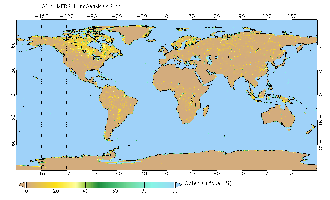
Land/Sea static mask relevant to IMERG precipitation 0.1x0.1 degree V2 (GPM_IMERG_LandSeaMask) at GES DISC recent views
National Aeronautics and Space Administration —
Version 2 is the current version of the data set. Older versions will no longer be available and have been superseded by Version 2. This land sea mask originated from... -
Federal
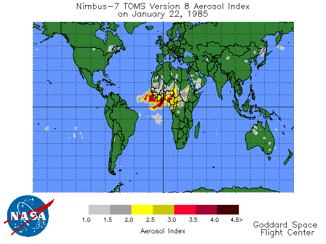
TOMS Earth Probe UV Aerosol Index Daily L3 Global 1 deg x 1.25 deg Lat/Lon Grid V008 (TOMSEPL3daer) at GES DISC recent views
National Aeronautics and Space Administration —
This Earth Probe (EP) Total Ozone Mapping Spectrometer (TOMS) version 8 daily global gridded data product contains UV aerosol index values. The data are mapped to a... -
Federal
Supercritical Airfoil Coordinates recent views
National Aeronautics and Space Administration —
Rectangular Supercritical Wing (Ricketts) - design and measured locations are provided in an Excel file RSW_airfoil_coordinates_ricketts.xls . One sheet is with Non... -
Federal
UNH TDP - Concurrent Measurements of Inflow, Power Performance, and Loads for a Grid-Synchronized Vertical Axis Cross-Flow Turbine Operating in a Tidal Estuary recent views
Department of Energy —
This data was collected between October 12 and December 15 of 2021 at the University of New Hampshire (UNH) and Atlantic Marine Energy Center (AMEC) turbine... -
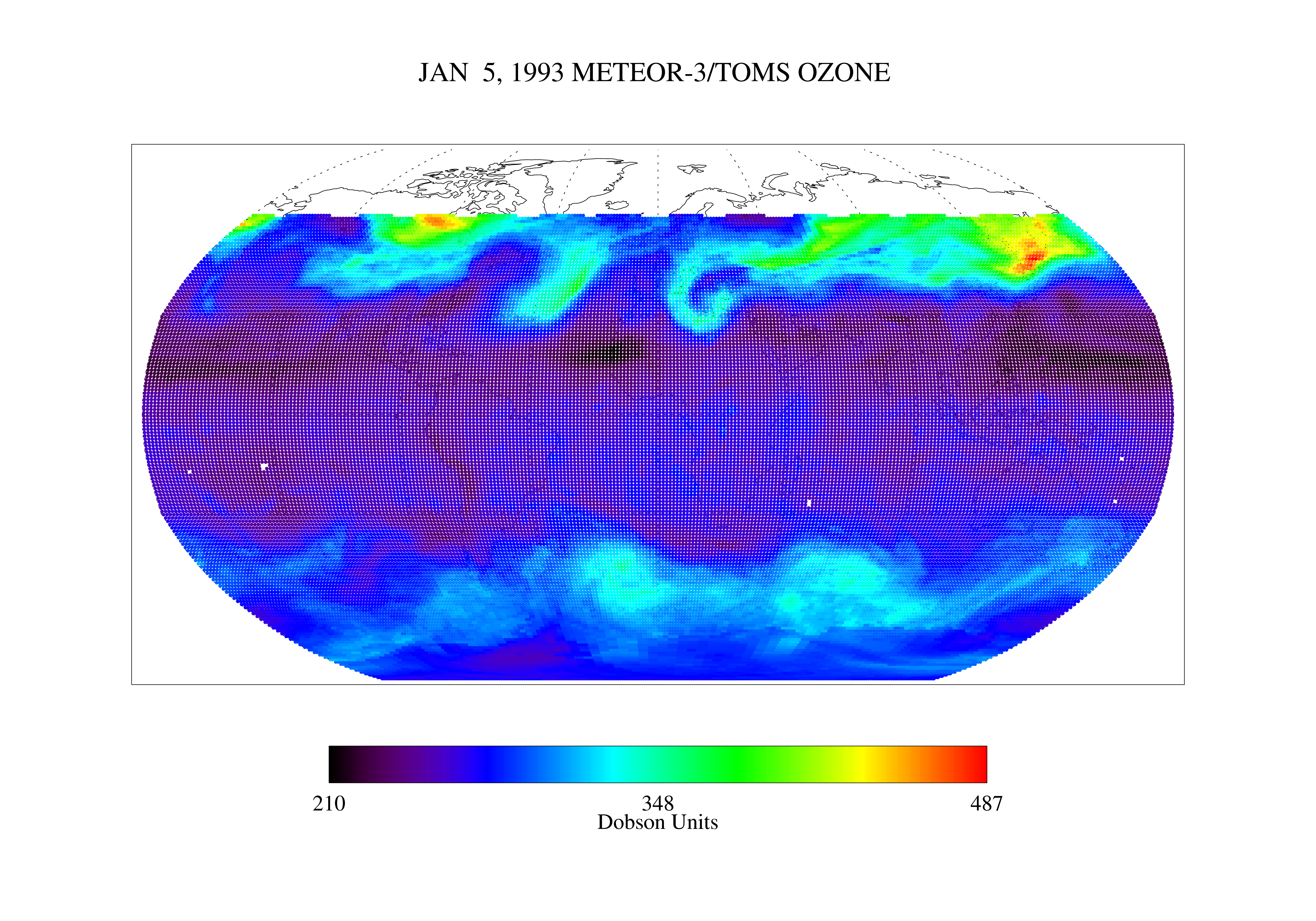
Federal
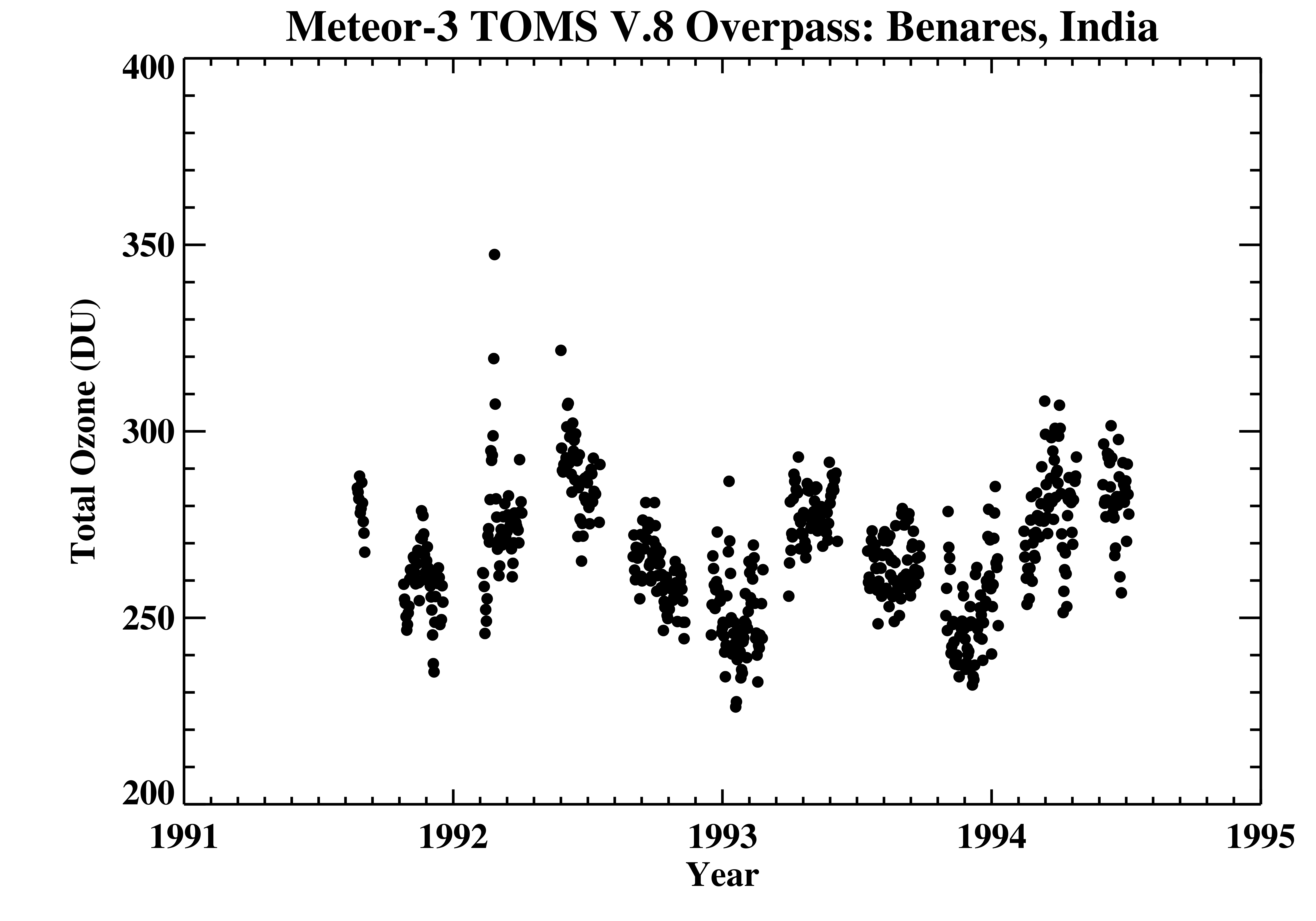
TOMS Meteor-3 Ground Station Overpass Data V008 (TOMSM3OVP) at GES DISC recent views
National Aeronautics and Space Administration —
The Meteor-3 Total Ozone Mapping Spectrometer (TOMS) version 8 daily ground station overpass data product contains total column ozone, UV aerosol index, Lambertian... -
Federal
TOMS Earth Probe UV Reflectivity Daily L3 Global 1 deg x 1.25 deg Lat/Lon Grid V008 (TOMSEPL3dref) at GES DISC recent views
National Aeronautics and Space Administration —
This Earth Probe (EP) Total Ozone Mapping Spectrometer (TOMS) version 8 daily global gridded data product contains Lambertian effective surface reflectivity values... -
Federal
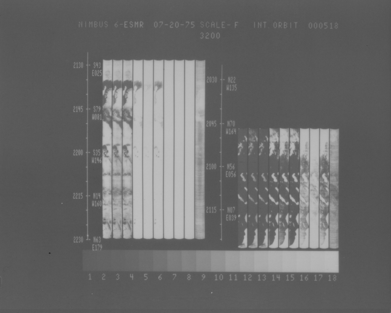
ESMR/Nimbus-6 Images of Brightness Temperature on 70 mm Film V001 (ESMRN6IM) at GES DISC recent views
National Aeronautics and Space Administration —
ESMRN6IM is the Nimbus-6 Electrically Scanning Microwave Radiometer (ESMR) data product containing daily brightness temperature images from 70-mm photofacsimile film... -
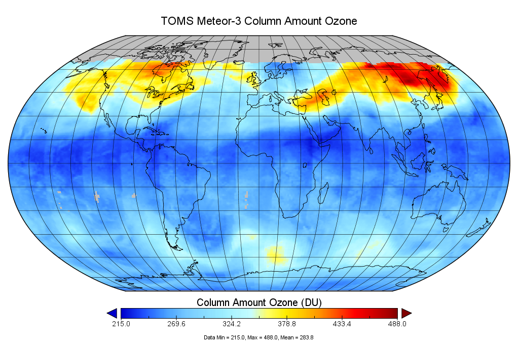
Federal
TOMS Meteor-3 Total Ozone UV-Reflectivity Daily L3 Global 1 deg x 1.25 deg V008 (TOMSM3L3) at GES DISC recent views
National Aeronautics and Space Administration —
The Meteor-3 Total Ozone Mapping Spectrometer (TOMS) version 8 daily global gridded data product contains total column ozone, UV aerosol index, Lambertian effective... -
Federal
TOMS Earth-Probe Ozone (O3) Total Column 1-Orbit L2 Swath 50 x 50 km V008 (TOMSEPL2) at GES DISC recent views
National Aeronautics and Space Administration —
The Earth Probe (EP) Total Ozone Mapping Spectrometer (TOMS) version 8 orbital swath data product contains total column ozone, UV aerosol index, and Lambertian... -
Federal
VISSR/GOES-3 Visible Imagery on 70mm Film V001 (VISSRGOES3IMVIS) at GES DISC recent views
National Aeronautics and Space Administration —
VISSRGOES3IMVIS is the Visible Infrared Spin-Scan Radiometer (VISSR) Visible Imagery on 70mm Film data product from the third Geostationary Operational Environmental... -
Federal
TOMS Earth Probe Total Column Ozone Daily L3 Global 1 deg x 1.25 deg Lat/Lon Grid V008 (TOMSEPL3dtoz) at GES DISC recent views
National Aeronautics and Space Administration —
This Earth Probe (EP) Total Ozone Mapping Spectrometer (TOMS) version 8 daily global gridded data product contains total column ozone values. The data are mapped to a... -
Federal
GVHRR/ATS-6 Black and White Visible Images on Film V001 (GVHRRATS6IMVIS) at GES DISC recent views
National Aeronautics and Space Administration —
GVHRRATS6IMVIS is the Geosynchronous Very High Resolution Radiometer (GVHRR) Black and White Visible Images on Film data product from the sixth Applications... -
Federal
LBA-ECO LC-24 Cadastral Property Map of Uruara, Para, Brazil: ca.1975 recent views
National Aeronautics and Space Administration —
This data set contains a shapefile of a digitized map of the land parcel information of the original properties of the Uruara colonization site, Para, Brazil,...

Official websites use .gov
A
.gov website belongs to an official government
organization in the United States.
Secure .gov websites use HTTPS
A
lock (
) or https:// means you’ve safely connected to
the .gov website. Share sensitive information only on official,
secure websites.