
-
Federal
Aboveground Biomass Density for High Latitude Forests from ICESat-2, 2020 recent views
National Aeronautics and Space Administration —
This dataset provides estimates of Aboveground dry woody Biomass Density (AGBD) for high northern latitude forests at a 30-m spatial resolution. It is designed both... -
Federal
Global Aboveground and Belowground Biomass Carbon Density Maps for the Year 2010 recent views
National Aeronautics and Space Administration —
This dataset provides temporally consistent and harmonized global maps of aboveground and belowground biomass carbon density for the year 2010 at a 300-m spatial... -
Federal
ABoVE: Lake and Wetland Classification from L-band SAR, Alaska and Canada, 2017-2019 recent views
National Aeronautics and Space Administration —
This dataset contains a high-resolution land cover classification focused on water and wetland vegetation classes over three NASA ABoVE Campaign regions: Yukon Flats,... -
Federal
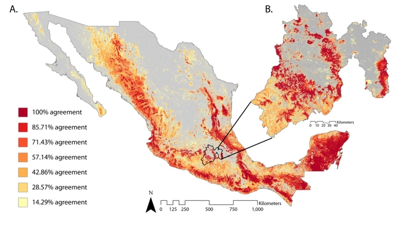
Satellite-Derived Forest Extent Likelihood Map for Mexico recent views
National Aeronautics and Space Administration —
This dataset provides a comparison of forest extent agreement from seven remote sensing-based products across Mexico. These satellite-derived products include... -
Federal
ABoVE: Distribution Maps of Wildland Fire Fuel Components across Alaskan Tundra, 2015 recent views
National Aeronautics and Space Administration —
This dataset provides maps of the distribution of three major wildland fire fuel types at 30 m spatial resolution covering the Alaskan arctic tundra, circa 2015. The... -
Federal
ABoVE: Thaw Depth at Selected Unburned and Burned Sites Across Alaska recent views
National Aeronautics and Space Administration —
This dataset provides thaw depth measurements made at seven locations across Alaska, during August 2016, June and September 2017, and July-August 2018. Three of the... -
Federal
Arctic Boreal Annual Burned Area, Circumpolar Boreal Forest and Tundra, V2, 2002-2022 NGDA recent views
National Aeronautics and Space Administration —
This dataset provides annual cumulative end-of-season burned area in circumpolar boreal forests and tundra for the years 2002-2022. The data were generated using the... -
Federal
Global Human Modification of Terrestrial Systems recent views
National Aeronautics and Space Administration —
The Global Human Modification of Terrestrial Systems data set provides a cumulative measure of the human modification of terrestrial lands across the globe at a 1-km... -
Federal
GEDI L4C Footprint Level Waveform Structural Complexity Index, Version 2 recent views
National Aeronautics and Space Administration —
This dataset contains Global Ecosystem Dynamics Investigation (GEDI) Level 4C (L4C) Version 2 predictions ofthe Waveform Structural Complexity Index (WSCI) and... -
Federal
ABoVE: Modeled Top Cover by Plant Functional Type over Alaska and Yukon, 1985-2020 recent views
National Aeronautics and Space Administration —
This dataset contains data files of modeled top cover estimates by plant functional type (PFT) for the Arctic and Boreal Alaska and Yukon regions. Estimates are... -
Federal
Ground-Based Vegetation Community Photos, Toolik Lake Area, Alaska, 2014-2015 recent views
National Aeronautics and Space Administration —
This dataset contains 731 ground-based nadir vegetation community and ground surface photographs of selected field plots taken as ground reference data for vegetation... -
Federal
ABoVE: Characterization of Carbon Dynamics in Burned Forest Plots, NWT, Canada, 2014 recent views
National Aeronautics and Space Administration —
This dataset provides field data from boreal forests in the Northwest Territories (NWT), Canada, that were burned by wildfires in 2014. During fieldwork in 2015, 211... -
Federal
Global-Gridded Daily Methane Emissions from Inland Dam-Reservoir Systems recent views
National Aeronautics and Space Administration —
This dataset includes global maps of methane (CH4) emissions from inland dam-reservoir systems at 0.25-degree spatial resolution. Daily emission rates (as grams of... -
Federal
Burned and Unburned Field Site Data, Noatak, Seward, and North Slope, AK, 2016-2018 recent views
National Aeronautics and Space Administration —
This dataset includes field measurements from unburned and burned 10 m x 10 m and 1 m x 1 m plots in the Noatak, Seward, and North Slope regions of the Alaskan tundra... -
Federal
Arctic Vegetation Plots in Flux Tower Footprints, North Slope, Alaska, 2014 recent views
National Aeronautics and Space Administration —
This data set provides vegetation, environmental, and soil data collected from plots located in the footprints of eddy covariance flux towers along a 300 km north-... -
Federal
Pre-Delta-X: L3 AirSWOT-derived Water Level Profiles, Wax Lake Outlet, LA, USA, 2015 recent views
National Aeronautics and Space Administration —
This dataset contains water level profiles generated from the AirSWOT data collected in the Atchafalaya Basin in Southern Louisiana, USA, within the Mississippi River... -
Federal
Arctic Vegetation Plots at ARCSS/LAII Flux Sites, North Slope, Alaska, 1995-1996 recent views
National Aeronautics and Space Administration —
This dataset provides vegetation cover and environmental plot and soil data collected at flux tower sites of the North Slope Arctic System Science/Land-Atmosphere-Ice... -
Federal
NDVI, Species Cover, and LAI, Burned and Unburned sites, Interior Alaska, 2017-2018 NGDA recent views
National Aeronautics and Space Administration —
This dataset provides leaf area index (LAI), tree species and canopy cover, normalized difference vegetation index (NDVI), and NDVI trends for boreal forests in... -
Federal
ABoVE: Burned Area, Depth, and Combustion for Alaska and Canada, 2001-2019 NGDA recent views
National Aeronautics and Space Administration —
This dataset provides annual gridded estimates of fire locations and associated burn fraction per pixel for Alaska and Canada at approximately 500 m spatial... -
Federal
Pre-Delta-X: Channel Bathymetry of the Atchafalaya Basin, LA, USA, 2016 recent views
National Aeronautics and Space Administration —
This dataset provides water depths and water surface elevations collected during bathymetric surveys of the main channel of the Wax Lake Delta within the Mississippi...

Official websites use .gov
A
.gov website belongs to an official government
organization in the United States.
Secure .gov websites use HTTPS
A
lock (
) or https:// means you’ve safely connected to
the .gov website. Share sensitive information only on official,
secure websites.