
-
Federal
Landsat 8 recent views
National Aeronautics and Space Administration —
The Operational Land Imager (OLI) and Thermal Infrared Sensor (TIRS) are onboard the Landsat 8 satellite, have acquired images of the Earth since February 2013. The... -
Federal
Shuttle Radar Topography Mission (SRTM) Images recent views
National Aeronautics and Space Administration —
Culminating more than four years of processing data, NASA and the National Geospatial-Intelligence Agency (NGA) have completed Earth's most extensive global... -
Federal
Shuttle Radar Topography Mission (SRTM) Version 2 recent views
National Aeronautics and Space Administration —
NASA has released version 2 of the Shuttle Radar Topography Mission digital topographic data (also known as the "finished" version). Version 2 is the result of a... -
Federal
USGS Digital Orthophoto Quadrangles recent views
National Aeronautics and Space Administration —
A Digital Orthophoto Quadrangle (DOQ) is a computer-generated image of an aerial photograph in which the image displacement caused by terrain relief and camera tilt... -
Federal
Global Multi-resolution Terrain Elevation Data 2010 (GMTED2010) recent views
National Aeronautics and Space Administration —
The USGS and the NGA have collaborated on the development of a notably enhanced global elevation model named the GMTED2010 that replaces GTOPO30 as the elevation... -
Federal
Global Sentinel-1 Burst ID Map recent views
National Aeronautics and Space Administration —
Sentinel-1 performs systematic acquisition of bursts in both IW and EW modes. The bursts overlap almost perfectly between different passes and are always located at... -
Federal
GTOPO30 Hydro 1K recent views
National Aeronautics and Space Administration —
HYDRO1k is a geographic database developed to provide comprehensive and consistent global coverage of topographically derived data sets, including streams, drainage... -
Federal
SENTINEL-1B_SINGLE_POL_GRD_HIGH_RES recent views
National Aeronautics and Space Administration —
Sentinel-1B Single-pol ground projected high and full resolution images -
Federal
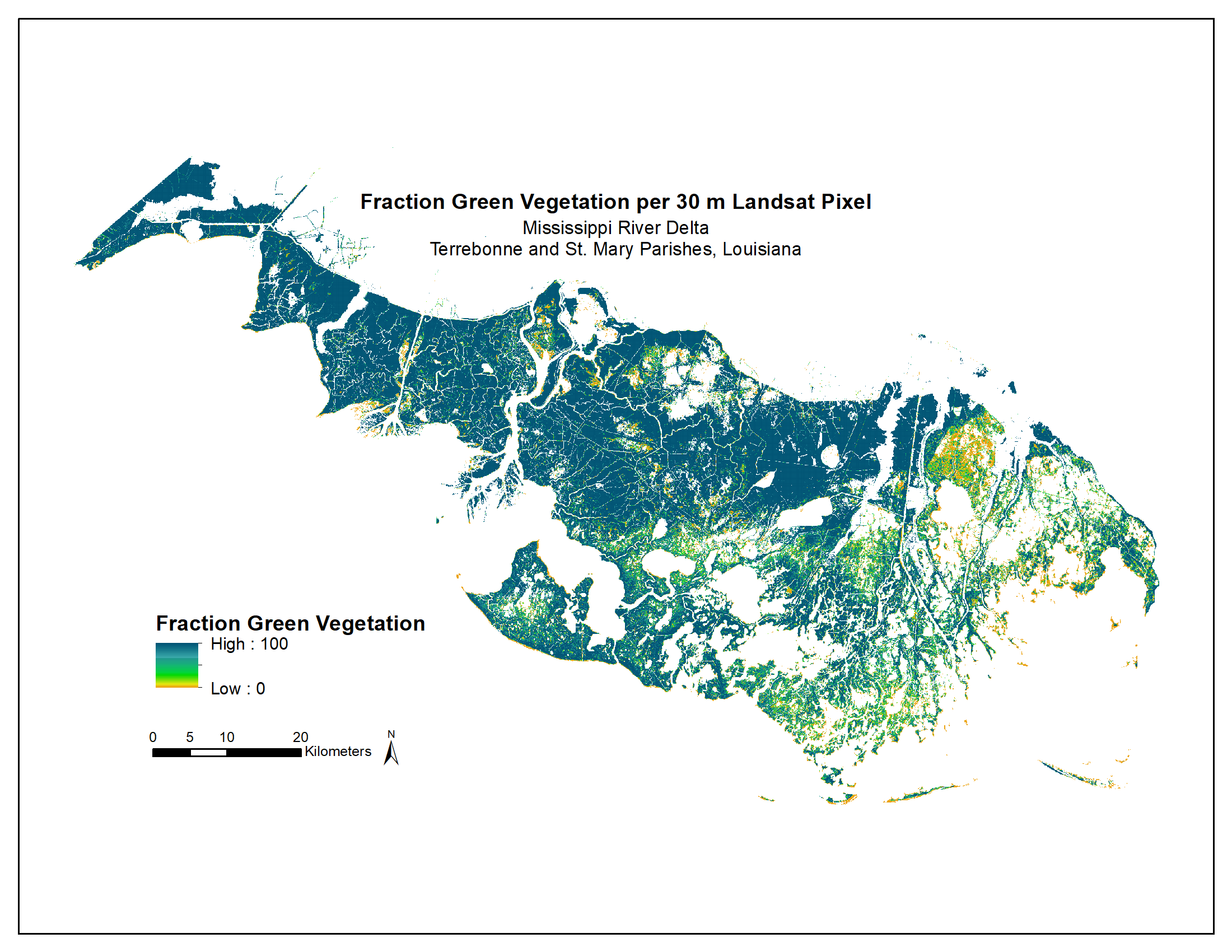
Green Vegetation Fraction High-Resolution Maps for Selected US Tidal Marshes, 2015 recent views
National Aeronautics and Space Administration —
This dataset provides 30m resolution maps of the fraction of green vegetation within tidal marshes for six estuarine regions of the conterminous United States: Cape... -
Federal
SRTM Water Body Data recent views
National Aeronautics and Space Administration —
The SRTM Water Body Data files are a by-product of the data editing performed by the National Geospatial-Intelligence Agency (NGA) to produce the finished SRTM... -
Federal
RADARSAT-1_LEVEL1 recent views
National Aeronautics and Space Administration —
RADARSAT-1 Level 1 Amplitude Images -
Federal
ALOS_PALSAR_LEVEL2.2 recent views
National Aeronautics and Space Administration —
ALOS PALSAR Level 2.2 -
Federal
SEASAT_SAR_LEVEL1_GEOTIFF recent views
National Aeronautics and Space Administration —
SEASAT Image GeoTIFF -
Federal
SENTINEL-1A_SINGLE_POL_GRD_FULL_RES recent views
National Aeronautics and Space Administration —
Sentinel-1A Single-pol ground range detected full resolution images -
Federal
RADARSAT-1_LEVEL0 recent views
National Aeronautics and Space Administration —
RADARSAT-1 Level 0 -
Federal
National Land Cover Database 2006 (NLCD2006) recent views
National Aeronautics and Space Administration —
National Land Cover Database 2006 (NLCD2006) is a 16-class land cover classification scheme that has been applied consistently across the conterminous United States... -
Federal
Resilience of Coastal Wetlands to Sea Level Rise, CONUS, 1996-2100 recent views
National Aeronautics and Space Administration —
This dataset provides information about the resilience of tidal wetlands to sea-level rise under three scenarios of global change. With rising seas, regularly... -
Federal
Delta-X: AVIRIS-NG L2 Surface Reflectance, MRD Louisiana, 2021 recent views
National Aeronautics and Space Administration —
This dataset provides Level 2 (L2) atmospherically corrected surface reflectance data acquired from NASA's Airborne Visible-Infrared Imaging Spectrometer-Next... -
Federal
Space Acquired Photography recent views
National Aeronautics and Space Administration —
Gemini photography was acquired between March 23, 1965 and November 15, 1966. The images were collected as part of the Synoptic Terrain Photography and the Synoptic...

Official websites use .gov
A
.gov website belongs to an official government
organization in the United States.
Secure .gov websites use HTTPS
A
lock (
) or https:// means you’ve safely connected to
the .gov website. Share sensitive information only on official,
secure websites.