Delta-X: AVIRIS-NG L2 Surface Reflectance, MRD Louisiana, 2021
Access & Use Information
Downloads & Resources
-
Google Scholar search resultsHTML
Search results for publications that cite this dataset by its DOI.
-
Download this datasetHTML
This link allows direct data access via Earthdata login
-
View documentation related to this datasetHTML
ORNL DAAC Data Set Documentation
-
This dataset's landing pageHTML
Data set Landing Page DOI URL
-
View documentation related to this datasetPDF
Delta-X: AVIRIS-NG L2 Surface Reflectance, MRD Louisiana, 2021:...
-
View documentation related to this datasetHTML
Delta-X: AVIRIS-NG L2 Surface Reflectance, MRD Louisiana, 2021:...
-
Get a related visualizationJPEG
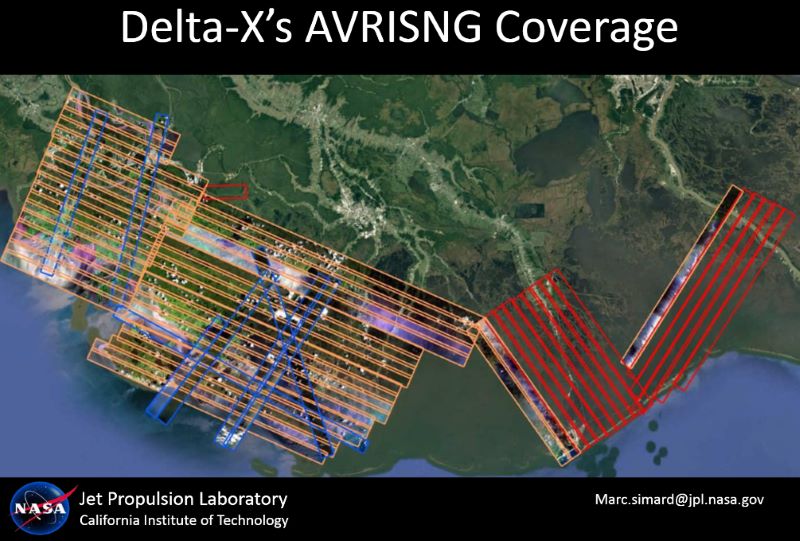
The Delta-X study region on the coast of Louisiana, U.S. Polygons show...
-
The dataset's project home pageHTML
Delta-X Project Site
-
Landing PageLanding Page
Dates
| Metadata Created Date | December 1, 2022 |
|---|---|
| Metadata Updated Date | December 6, 2023 |
Metadata Source
- Data.json Data.json Metadata
Harvested from NASA Data.json
Graphic Preview

Additional Metadata
| Resource Type | Dataset |
|---|---|
| Metadata Created Date | December 1, 2022 |
| Metadata Updated Date | December 6, 2023 |
| Publisher | ORNL_DAAC |
| Maintainer | |
| Identifier | C2430019879-ORNL_CLOUD |
| Data First Published | 2022-08-29 |
| Language | en-US |
| Data Last Modified | 2023-06-12 |
| Category | Delta-X, geospatial |
| Public Access Level | public |
| Bureau Code | 026:00 |
| Metadata Context | https://project-open-data.cio.gov/v1.1/schema/catalog.jsonld |
| Metadata Catalog ID | https://data.nasa.gov/data.json |
| Schema Version | https://project-open-data.cio.gov/v1.1/schema |
| Catalog Describedby | https://project-open-data.cio.gov/v1.1/schema/catalog.json |
| Citation | Thompson, D.R., D.J. Jensen, J.W. Chapman, E. Greenberg, and M. Simard. 2022. Delta-X: AVIRIS-NG L2 Surface Reflectance, MRD Louisiana, 2021. ORNL DAAC, Oak Ridge, Tennessee, USA. https://doi.org/10.3334/ORNLDAAC/1988 |
| Graphic Preview Description | The Delta-X study region on the coast of Louisiana, U.S. Polygons show AVIRIS-NG Flight Lines. |
| Graphic Preview File | https://daac.ornl.gov/DELTAX/guides/DeltaX_L2_AVIRIS_Reflectance_Fig1.jpg |
| Harvest Object Id | 2f6d77f1-e4ee-47e8-85b1-0a1925081a3c |
| Harvest Source Id | 58f92550-7a01-4f00-b1b2-8dc953bd598f |
| Harvest Source Title | NASA Data.json |
| Homepage URL | https://doi.org/10.3334/ORNLDAAC/1988 |
| Metadata Type | geospatial |
| Old Spatial | -91.64 29.02 -89.59 29.85 |
| Program Code | 026:001 |
| Source Datajson Identifier | True |
| Source Hash | f7b2996c7af74249d129a4f32b534f92c61dcf628deb981c116890d9504d2761 |
| Source Schema Version | 1.1 |
| Spatial | |
| Temporal | 2021-03-27T00:00:00Z/2021-09-25T23:59:59Z |
Didn't find what you're looking for? Suggest a dataset here.

