
-
Federal
EMAG2v3: Earth Magnetic Anomaly Grid (2-arc-minute resolution)
National Oceanic and Atmospheric Administration, Department of Commerce —
EMAG2v3 is a global Earth Magnetic Anomaly Grid compiled from satellite, ship, and airborne magnetic measurements. It is a significant update of the previous release... -
Federal
UAV image and ground data of two citrus 'Valencia' orange (<i>Citrus</i> sinensis [L.] Osbeck) rootstock trials
Department of Agriculture —
The data are UAV (Unmanned Aerial Vehicle) and individual tree ground measurements collected from 2 citrus rootstock trials at the U.S. Horticultural Research... -
Federal
2023 National Offshore Wind data set (NOW-23)
Department of Energy —
The 2023 National Offshore Wind data set (NOW-23) is the latest wind resource data set for offshore regions in the United States, which supersedes, for its offshore... -
Federal
Radio Frequency Interference Measurements of Industrial Machinery
Department of Commerce —
The 2.4 GHz ISM band is shared by Wi-Fi, Bluetooth, Wireless HART, ISA100.11a, and several other industrial wireless systems. Our dataset contains comprehensive... -
Federal
Supercritical Airfoil Coordinates
National Aeronautics and Space Administration —
Rectangular Supercritical Wing (Ricketts) - design and measured locations are provided in an Excel file RSW_airfoil_coordinates_ricketts.xls . One sheet is with Non... -
Federal
EMIT L2B Methane Enhancement Data 60 m V002
National Aeronautics and Space Administration —
The Earth Surface Mineral Dust Source Investigation (EMIT) instrument measures surface mineralogy, targeting the Earth’s arid dust source regions. EMIT is installed... -
Federal
OCO-2 Level 2 geolocated XCO2 retrievals results, physical model V11.2 (OCO2_L2_Standard) at GES DISC
National Aeronautics and Space Administration —
Version 11.2 is the current version of the data set. Older versions will no longer be available and are superseded by Version 11.2. The Orbiting Carbon Observatory is... -
Federal
HAQAST Sentinel-5P TROPOMI Nitrogen Dioxide (NO2) GLOBAL Monthly Level 3 0.1 x 0.1 Degree Gridded Data Version 2.4 (HAQ_TROPOMI_NO2_GLOBAL_M_L3) at GES DISC
National Aeronautics and Space Administration —
This product provides level 3 monthly averages of tropospheric Nitrogen dioxide (NO2) vertical column density derived from the level 2 Tropospheric Monitoring... -
Federal
Radio Frequency Interference Measurements of Industrial Machinery
National Institute of Standards and Technology —
The 2.4 GHz ISM band is shared by Wi-Fi, Bluetooth, Wireless HART, ISA100.11a, and several other industrial wireless systems. Our dataset contains comprehensive... -
Federal
ECOSTRESS Gridded Downscaled Meteorology Instantaneous L3 Global 70 m V002
National Aeronautics and Space Administration —
The ECOsystem Spaceborne Thermal Radiometer Experiment on Space Station (ECOSTRESS) mission measures the temperature of plants to better understand how much water... -
Federal
GEDI L2A Elevation and Height Metrics Data Global Footprint Level V002
National Aeronautics and Space Administration —
The Global Ecosystem Dynamics Investigation (GEDI) mission aims to characterize ecosystem structure and dynamics to enable radically improved quantification and... -
Federal
Optical scattering measurements and simulation data for one-dimensional (1-D) patterned periodic sub-wavelength features
National Institute of Standards and Technology —
This data set consists of both measured and simulated optical intensities scattered off periodic line arrays, with simulations based upon an average geometric model... -
Federal
NASA Earth Observations (NEO)
National Aeronautics and Space Administration —
Our mission is to help you picture climate change and environmental changes happening on our home planet. Here you can search for and retrieve satellite images of... -
Federal
GEOS-Carb CASA-GFED Daily Fire and Fuel Emissions 0.5 degree x 0.5 degree V3 (GEOS_CASAGFED_D_FIRE) at GES DISC
National Aeronautics and Space Administration —
This product provides Daily average wildfire emissions (FIRE) andfuel wood burning emissions (FUEL) derived from the Carnegie-Ames-Stanford-Approach – Global Fire... -
Federal
NASA 3D Models: Skylab
National Aeronautics and Space Administration —
Skylab model. Polygons: 27533 Vertices: 15041 -
Federal
Sentinel-5P TROPOMI Total Ozone Column 1-Orbit L2 7km x 3.5km V1 (S5P_L2__O3_TOT) at GES DISC
National Aeronautics and Space Administration —
Starting from August 6th in 2019, Sentinel-5P TROPOMI along-track high spatial resolution (~5.5km at nadir) has been implemented. Starting from July 13th in 2020,... -
Federal
TRMM Precipitation Radar Rain Characteristics L2 1.5 hours V7 (TRMM_2A23) at GES DISC
National Aeronautics and Space Administration —
The new version of these data is in GPM-like format (consistent with the GPM Dual-frequency Radar data format), and can be found under the name GPM_2APR. The TRMM... -
Federal
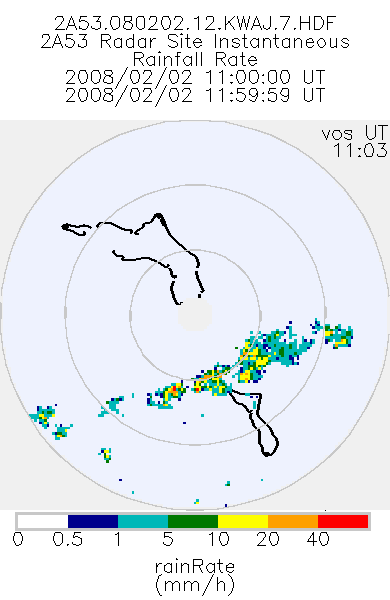
TRMM Ground Validation Radar Site Rain Rate Map L2 1 hour 2 km V7 (TRMM_2A53UW) at GES DISC
National Aeronautics and Space Administration —
This dataset is part of the University of Washington TRMM Ground Validation products. Instantaneous rain rate cartesian grid based on baseUW and 2A54UW. Units are... -
Federal
SHIFT: Wetland Spectra, Salinity, and Fractional Cover, Devereux Slough, CA, 2022
National Aeronautics and Space Administration —
This dataset includes field data, analysis code, and corresponding airborne imagery collected and generated during the 2022 NASA Surface Biology Geology (SBG) High... -
Federal
EMIT L2B Estimated Mineral Identification and Band Depth and Uncertainty 60 m V001
National Aeronautics and Space Administration —
The Earth Surface Mineral Dust Source Investigation (EMIT) instrument measures surface mineralogy, targeting the Earth’s arid dust source regions. EMIT is installed...

Official websites use .gov
A
.gov website belongs to an official government
organization in the United States.
Secure .gov websites use HTTPS
A
lock (
) or https:// means you’ve safely connected to
the .gov website. Share sensitive information only on official,
secure websites.