
-
Federal
White-nose Syndrome Surveillance and Bat Monitoring Activities in North Coast and Cascades Network Parks, 2016–2024
Department of the Interior —
This data package contains National Park Service (NPS) and United States Geological Survey (USGS) white-nose syndrome disease surveillance tabular data collected... -
Federal
Terrestrial Ecosystems - Land Surface Forms of the Conterminous United States
Department of the Interior —
The U.S. Geological Survey (USGS) has generated land surface form classes for the contiguous United States. These land surface form classes were created as part of an... -
Federal
Klamath Basin Restoration Agreement Off-Project Water Program Evapotranspiration Map for May 2004
Department of the Interior —
Hydrological Information Products for the Off-Project Water Program of the Klamath Basin Restoration Agreement U.S. Geological Survey Open-File Report 2012-1199 U.S.... -
Federal
Thermal Infrared Airborne Imagery and Longitudinal Profiles of Stream Temperatures, Hat Creek, California, August 2018
Department of the Interior —
This dataset includes georeferenced high-resolution, airborne thermal infrared (TIR) imagery, a polyline shapefile of the channel centerline, and a tabular file with... -
Federal
Argos Satellite Tracking Data for Pacific Walrus (Odobenus rosmarus divergens) - Processed Data
Department of the Interior —
This metadata document describes the data contained in the "Argos Processed Data" (Child Item 1) of this data release. This data release contains all data collected... -
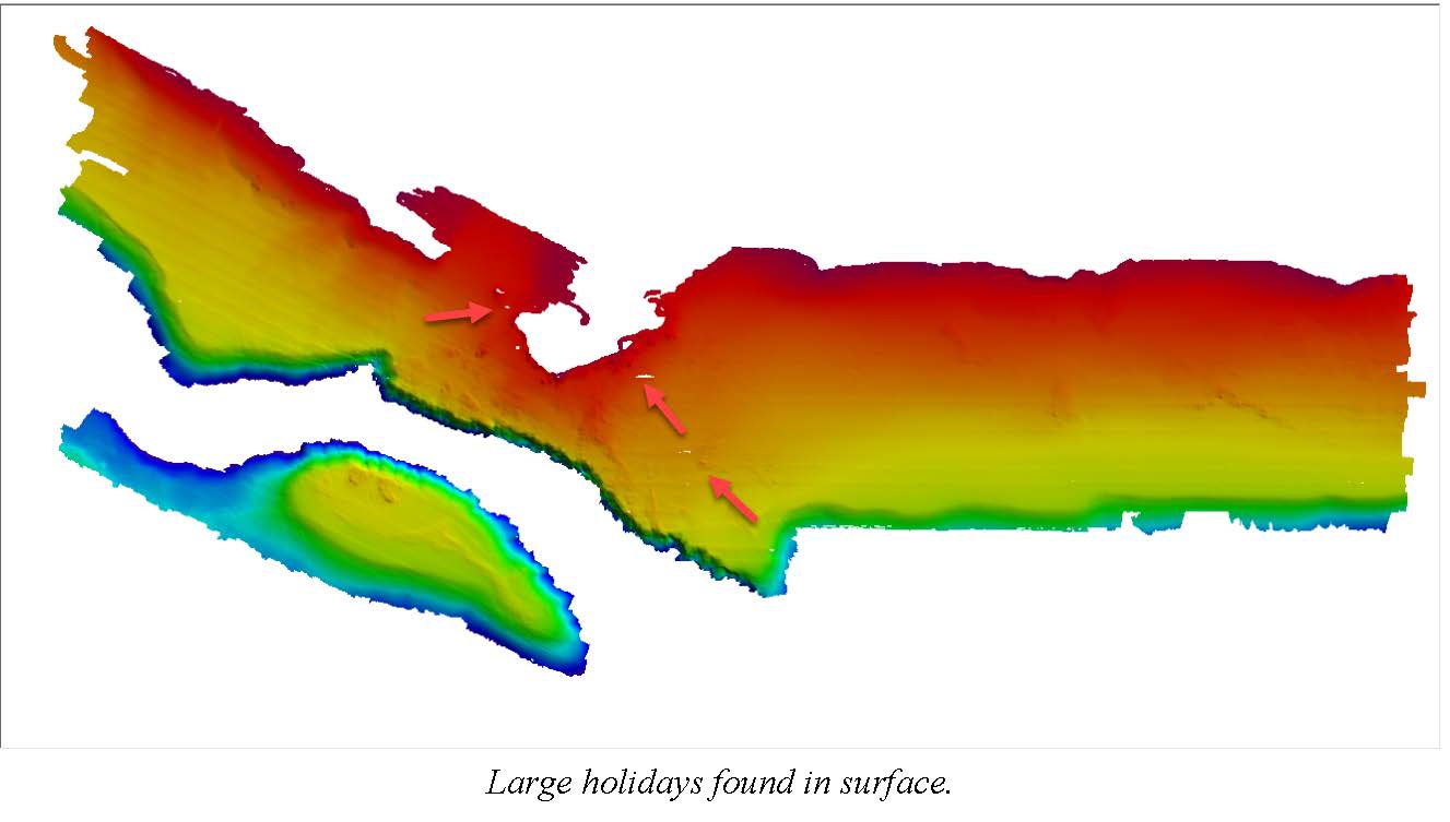
Federal
Bathymetry--Offshore of Santa Barbara, California
Department of the Interior —
This part of DS 781 presents data for the bathymetry map of the Offshore of Santa Barbara map area, California. The raster data file is included in... -
Federal
1995 - 2007 Ecosystem History of South Florida's Estuaries Database
Department of the Interior —
The 1995 - 2007 Ecosystem History of South Florida's Estuaries Database contains listings of all sites (modern and core), modern monitoring site survey information... -
Federal
Multichannel seismic-reflection data acquired off the coast of southern California - Part A 1997, 1998, 1999, and 2000
Department of the Interior —
Multichannel seismic-reflection (MCS) data were collected in the California Continental Borderland as part of southern California Earthquake Hazards Task. Five data... -
Federal
H08333: NOS Hydrographic Survey , Guemes Channel, Bellingham Channel and Rosario Strait, Washington, 1955-09-09
National Oceanic and Atmospheric Administration, Department of Commerce —
The National Oceanic and Atmospheric Administration (NOAA) has the statutory mandate to collect hydrographic data in support of nautical chart compilation for safe... -
Federal
BLM UT GRSG Seasonal Habitats (Polygon)
Department of the Interior —
This polygon feature class represents the spatial extent and boundaries for the Utah Greater Sage-Grouse (GRSG) seasonal habitats, as modeled by the Utah State... -
Federal
H10983C: NOS Hydrographic Survey , Salem Sound, Massachusetts, 2000-06-27
National Oceanic and Atmospheric Administration, Department of Commerce —
The National Oceanic and Atmospheric Administration (NOAA) has the statutory mandate to collect hydrographic data in support of nautical chart compilation for safe... -
Federal
Interpretation of the seabed geologic substrates in quadrangle 2 of the Stellwagen Bank National Marine Sanctuary region offshore of Boston, Massachusetts based on data collected by the U.S. Geological Survey from 1993-2019
Department of the Interior —
The U.S. Geological Survey (USGS), in cooperation with the National Marine Sanctuary Program of the National Oceanic and Atmospheric Administration (NOAA), has... -
Federal
Fishes of the Harney Basin revisited: A contemporary assessment of the distribution of fish fauna throughout the Harney Basin from 1990 to 2019 (ver. 2.0, April 2022)
Department of the Interior —
We compiled electrofishing and habitat data sampled from 1990 to 2019 in the Harney Basin by the US Geological Survey (USGS), Oregon Department of Fish and Wildlife... -
Federal
Cross-Section Geometry and Sediment-Size Distribution Data from Muddy Creek and North Fork Gunnison River below Paonia Reservoir, 2015
Department of the Interior —
This data set contains cross-section geometry and sediment-size distribution data collected in the fall of 2015 from Muddy Creek and North Fork Gunnison River below... -
Federal
SEG-Y format of EdgeTech SB-512i seismic-reflection profiles collected by the U.S. Geological Survey - Woods Hole Coastal and Marine Science Center offshore of the Gulf Islands, MS, 2010.
Department of the Interior —
In 2010, the U.S. Geological Survey in Woods Hole, MA and St. Petersburg, FL, in partnership with the U.S. Army Corps of Engineers, Mobile District conducted geologic... -
Federal
Native and Non-Native Fish Species in the Willamette River Basin, Oregon
Department of the Interior —
The Willamette River Basin, Oregon, supports native fish species and non-native fish species introduced for sport fisheries or accidentally from aquarium releases and... -
Federal
Digital Elevation Model
Department of the Interior —
Bathymetric, topographic, and grain-size data were collected in April 2011 along a 27-mi (43.5 – km) reach of the Colorado River in Grand Canyon National Park,... -
Federal
W00460: NOS Hydrographic Survey , External Source Data 2018, 2003-06-27
National Oceanic and Atmospheric Administration, Department of Commerce —
The National Oceanic and Atmospheric Administration (NOAA) has the statutory mandate to collect hydrographic data in support of nautical chart compilation for safe... -
Federal
W00464: NOS Hydrographic Survey , External Source Data 2018, 2003-06-13
National Oceanic and Atmospheric Administration, Department of Commerce —
The National Oceanic and Atmospheric Administration (NOAA) has the statutory mandate to collect hydrographic data in support of nautical chart compilation for safe... -
Federal
H08846: NOS Hydrographic Survey , Muskeget Channel and Wasque and Mutton Shoals, Massachusetts, 1965-08-27
National Oceanic and Atmospheric Administration, Department of Commerce —
The National Oceanic and Atmospheric Administration (NOAA) has the statutory mandate to collect hydrographic data in support of nautical chart compilation for safe...

Official websites use .gov
A
.gov website belongs to an official government
organization in the United States.
Secure .gov websites use HTTPS
A
lock (
) or https:// means you’ve safely connected to
the .gov website. Share sensitive information only on official,
secure websites.