
-
Federal
Global Roads Open Access Data Set, Version 1 (gROADSv1)
National Aeronautics and Space Administration —
The Global Roads Open Access Data Set, Version 1 (gROADSv1) was developed under the auspices of the CODATA Global Roads Data Development Task Group. The data set... -
Federal
A Global Database of Gas Fluxes from Soils after Rewetting or Thawing, Version 1.0
National Aeronautics and Space Administration —
This database contains information compiled from published studies on gas flux from soil following rewetting or thawing. The resulting database includes 222 field and... -
Federal
New Caledonia Pre-SWOT Level-4 Hourly MITgcm LLC4320 Native Grid 2km Oceanographic Dataset Version 1.0
National Aeronautics and Space Administration —
This dataset provides a regional multivariate oceanographic state estimate from a global ocean numerical simulation with a focus on the New Caledonia region. The... -
Federal
CAR INTEX-B Long-range Pollution Transportation L1 V1 (CAR_INTEXB_L1C) at GES DISC
National Aeronautics and Space Administration —
INTEX-B (Intercontinental Chemical Transport Experiment-Phase B) focuses on the long-range transport of pollution, global atmospheric photochemistry, and the effects... -
Federal
MASTER: FireSense, western US, October 2023
National Aeronautics and Space Administration —
This dataset includes Level 1B (L1B) data products from the MODIS/ASTER Airborne Simulator (MASTER) instrument. The spectral data were collected as part of the... -
Federal
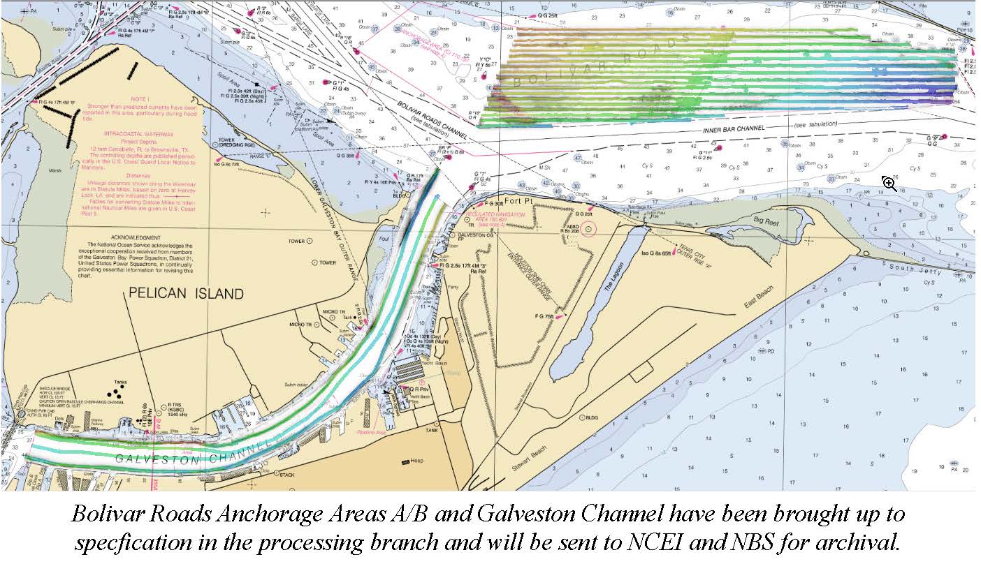
D00185: NOS Hydrographic Survey , Approaches to Portsmouth, NH, 2013-09-13
National Oceanic and Atmospheric Administration, Department of Commerce —
The National Oceanic and Atmospheric Administration (NOAA) has the statutory mandate to collect hydrographic data in support of nautical chart compilation for safe... -
Federal
CRED Cumulative Map of Percent Scleractinian Coral Cover at Oahu, 2005
National Oceanic and Atmospheric Administration, Department of Commerce —
This map displays optical validation observation locations and percent coverage of scleractinian coral overlaid on bathymetry. -
Federal
Northwest Pacific Pre-SWOT Level-4 Hourly MITgcm LLC4320 Native Grid 2km Oceanographic Dataset Version 1.0
National Aeronautics and Space Administration —
This dataset provides a regional multivariate oceanographic state estimate from a global ocean numerical simulation with a focus on the Northwest Pacific Ocean... -
Federal
Predicted Habitat Suitability for Leptoseris in the Au'au Channel Region
National Oceanic and Atmospheric Administration, Department of Commerce —
This raster denotes predicted habitat suitability for Leptoseris in the Au'au Channel region. Maximum Entropy (MaxEnt) modeling software was used to create this... -
Federal
CRED Cumulative Map of Percent Scleractinian Coral Cover at Molokai, 2005
National Oceanic and Atmospheric Administration, Department of Commerce —
This map displays optical validation observation locations and percent coverage of scleractinian coral overlaid on bathymetry. -
Federal
F00775: NOS Hydrographic Survey , 2019-06-04
National Oceanic and Atmospheric Administration, Department of Commerce —
The National Oceanic and Atmospheric Administration (NOAA) has the statutory mandate to collect hydrographic data in support of nautical chart compilation for safe... -
Federal
Global Reservoir and Dam Database, Version 1 (GRanDv1): Dams, Revision 01
National Aeronautics and Space Administration —
The Global Reservoir and Dam Database, Version 1, Revision 01 (v1.01) contains 6,862 records of reservoirs and their associated dams with a cumulative storage... -
Federal
BOREAS RSS-18 Level 1B AVIRIS At-Sensor Radiance Imagery
National Aeronautics and Space Administration —
This dataset holds Level 1B (L1B) radiance data collected by the AVIRIS-Classic instrument near Prince Albert, Saskatchewan, Canada, on August 14, 1996. This imagery... -
Federal
CAR FIREACE Arctic Ice and Cloud Radiation BRDF V2 (CAR_FIREACE_BRDF) at GES DISC
National Aeronautics and Space Administration —
The scientific objectives of FIRE/ACE are to study impact of Arctic clouds on radiation exchange between surface, atmosphere, and space, and the influence of surface... -
Federal
IPCC Fifth Assessment Report (AR5) Observed Climate Change Impacts Database, Version 2.01
National Aeronautics and Space Administration —
The Intergovernmental Panel on Climate Change Fifth Assessment Report (AR5) Observed Climate Change Impacts Database, Version 2.01 contains observed responses to... -
Federal
MASTER: California Fires, California, November 2007
National Aeronautics and Space Administration —
This dataset includes Level 1B (L1B) data products from the MODIS/ASTER Airborne Simulator (MASTER) instrument. The spectral data were collected during six flights... -
Federal
SPURS-2 Rawinsonde meteorological data for the E. Tropical Pacific field campaign R/V Revelle cruises
National Aeronautics and Space Administration —
The SPURS (Salinity Processes in the Upper Ocean Regional Study) project is NASA-funded oceanographic process study and associated field program that aim to elucidate... -
Federal
MiCASA Daily NPP Rh ATMC NEE FIRE FUEL Fluxes 0.1 degree x 0.1 degree
National Aeronautics and Space Administration —
MiCASA is an extensive revision of CASA-GFED3. CASA-GFED3 derives from Potter et al. (1993), diverging in development since Randerson et al. (1996). CASA is a light... -
Federal
D00230: NOS Hydrographic Survey , 2017-09-07
National Oceanic and Atmospheric Administration, Department of Commerce —
The National Oceanic and Atmospheric Administration (NOAA) has the statutory mandate to collect hydrographic data in support of nautical chart compilation for safe... -
Federal
Delta-X: Digital Elevation Model, MRD, LA, USA, 2021
National Aeronautics and Space Administration —
This dataset provides an updated digital elevation model (DEM) for the Atchafalaya and Terrebonne basins in coastal Louisiana, USA. The DEM is updated from the Pre-...

Official websites use .gov
A
.gov website belongs to an official government
organization in the United States.
Secure .gov websites use HTTPS
A
lock (
) or https:// means you’ve safely connected to
the .gov website. Share sensitive information only on official,
secure websites.