
-
Federal
H13003: NOS Hydrographic Survey , 2017-08-14
National Oceanic and Atmospheric Administration, Department of Commerce —
The National Oceanic and Atmospheric Administration (NOAA) has the statutory mandate to collect hydrographic data in support of nautical chart compilation for safe... -
Federal
Predicted Habitat Suitability for Leptoseris in the Au'au Channel Region
National Oceanic and Atmospheric Administration, Department of Commerce —
This raster denotes predicted habitat suitability for Leptoseris in the Au'au Channel region. Maximum Entropy (MaxEnt) modeling software was used to create this... -
Federal
H12106: NOS Hydrographic Survey , Southwest Alaska Peninsula, Alaska, 2009-08-12
National Oceanic and Atmospheric Administration, Department of Commerce —
The National Oceanic and Atmospheric Administration (NOAA) has the statutory mandate to collect hydrographic data in support of nautical chart compilation for safe... -
Federal
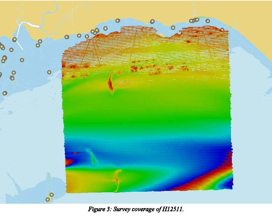
H12511: NOS Hydrographic Survey , 2020-11-19
National Oceanic and Atmospheric Administration, Department of Commerce —
The National Oceanic and Atmospheric Administration (NOAA) has the statutory mandate to collect hydrographic data in support of nautical chart compilation for safe... -
Federal
H12510: NOS Hydrographic Survey , 2014-11-06
National Oceanic and Atmospheric Administration, Department of Commerce —
The National Oceanic and Atmospheric Administration (NOAA) has the statutory mandate to collect hydrographic data in support of nautical chart compilation for safe... -
Federal
H13548: NOS Hydrographic Survey , 2021-10-17
National Oceanic and Atmospheric Administration, Department of Commerce —
The National Oceanic and Atmospheric Administration (NOAA) has the statutory mandate to collect hydrographic data in support of nautical chart compilation for safe... -
Federal
CRED Cumulative Map of Percent Scleractinian Coral Cover at Molokai, 2005
National Oceanic and Atmospheric Administration, Department of Commerce —
This map displays optical validation observation locations and percent coverage of scleractinian coral overlaid on bathymetry. -
Federal
H11252: NOS Hydrographic Survey , Eastern Long Island Sound, Connecticut and New York, 2004-11-15
National Oceanic and Atmospheric Administration, Department of Commerce —
The National Oceanic and Atmospheric Administration (NOAA) has the statutory mandate to collect hydrographic data in support of nautical chart compilation for safe... -
Federal
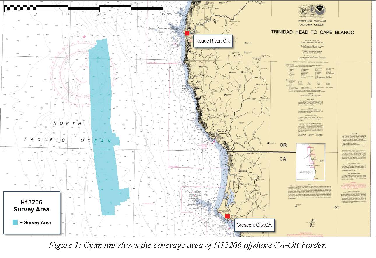
H13206: NOS Hydrographic Survey , 2018-08-15
National Oceanic and Atmospheric Administration, Department of Commerce —
The National Oceanic and Atmospheric Administration (NOAA) has the statutory mandate to collect hydrographic data in support of nautical chart compilation for safe... -
Federal
H13371: NOS Hydrographic Survey , 2020-09-17
National Oceanic and Atmospheric Administration, Department of Commerce —
The National Oceanic and Atmospheric Administration (NOAA) has the statutory mandate to collect hydrographic data in support of nautical chart compilation for safe... -
Federal
H12108: NOS Hydrographic Survey , Southwest Alaska Peninsula, Alaska, 2009-08-12
National Oceanic and Atmospheric Administration, Department of Commerce —
The National Oceanic and Atmospheric Administration (NOAA) has the statutory mandate to collect hydrographic data in support of nautical chart compilation for safe... -
Federal
CRED Cumulative Map of Percent Scleractinian Coral Cover at Oahu, 2005
National Oceanic and Atmospheric Administration, Department of Commerce —
This map displays optical validation observation locations and percent coverage of scleractinian coral overlaid on bathymetry. -
Federal
CRED Optical Validation Data at the island of Ta'u in American Samoa, 2012 to support Benthic Habitat Mapping (TOAD)
National Oceanic and Atmospheric Administration, Department of Commerce —
Optical validation data were collected using the Tethered Optical Assessment Device (TOAD), a sled equipped with underwater video camera, still camera and lights.... -
Federal
F00231: NOS Hydrographic Survey , Special Project, Addendum to Chart Evaluation Survey, New York Harbor, 1981-04-07
National Oceanic and Atmospheric Administration, Department of Commerce —
The National Oceanic and Atmospheric Administration (NOAA) has the statutory mandate to collect hydrographic data in support of nautical chart compilation for safe... -
Federal
H12105: NOS Hydrographic Survey , Southwest Alaska Peninsula, Alaska, 2009-08-12
National Oceanic and Atmospheric Administration, Department of Commerce —
The National Oceanic and Atmospheric Administration (NOAA) has the statutory mandate to collect hydrographic data in support of nautical chart compilation for safe... -
Federal
H13304: NOS Hydrographic Survey , 2020-10-22
National Oceanic and Atmospheric Administration, Department of Commerce —
The National Oceanic and Atmospheric Administration (NOAA) has the statutory mandate to collect hydrographic data in support of nautical chart compilation for safe... -
Federal
CRED Cumulative Map of Percent Scleractinian Coral Cover at Esmerelda Bank
National Oceanic and Atmospheric Administration, Department of Commerce —
This map displays optical validation observation locations and percent coverage of scleractinian coral overlaid on bathymetry. -
Federal
Predicted Habitat Suitability for All Mesophotic Corals in the Au'au Channel Region
National Oceanic and Atmospheric Administration, Department of Commerce —
This dataset is located between the islands of Maui, Lanai, Molokai and Kahoolawe, and includes the Au'au Channel as well as parts of the Kealaikahiki, Alalakeiki and... -
Federal
H10363: NOS Hydrographic Survey , Corpus Christi and Aransas Bays, Texas, 1991-02-15
National Oceanic and Atmospheric Administration, Department of Commerce —
The National Oceanic and Atmospheric Administration (NOAA) has the statutory mandate to collect hydrographic data in support of nautical chart compilation for safe... -
Federal
CRED Cumulative Map of Percent Scleractinian Coral Cover at Laysan Island, 2002-2004
National Oceanic and Atmospheric Administration, Department of Commerce —
This map displays optical validation observation locations and percent coverage of scleractinian coral overlaid on bathymetry.

Official websites use .gov
A
.gov website belongs to an official government
organization in the United States.
Secure .gov websites use HTTPS
A
lock (
) or https:// means you’ve safely connected to
the .gov website. Share sensitive information only on official,
secure websites.
.jpg)