
-
Federal
EMAG2v3: Earth Magnetic Anomaly Grid (2-arc-minute resolution)
National Oceanic and Atmospheric Administration, Department of Commerce —
EMAG2v3 is a global Earth Magnetic Anomaly Grid compiled from satellite, ship, and airborne magnetic measurements. It is a significant update of the previous release... -
Federal
CALIPSO Lidar Level 3 Ice Cloud Data, Standard V1-00
National Aeronautics and Space Administration —
CAL_LID_L3_Ice_Cloud-Standard-V1-00 is the Cloud-Aerosol Lidar and Infrared Pathfinder Satellite Observation (CALIPSO) Lidar Level 3 Ice Cloud Data, Standard Version... -
Federal
UAV image and ground data of citrus 'Bingo' mandarin hybrid (<i>Citrus </i>reticulata, Blanco) rootstock trial
Department of Agriculture —
The data are UAV ( (Unmanned Aerial Vehicle) and individual tree ground measurements collected in 2021 of 206 trees that were part of a citrus rootstock trial at the... -
Federal
A Global Database of Field-observed Leaf Area Index in Woody Plant Species, 1932-2011
National Aeronautics and Space Administration —
This data set provides global leaf area index (LAI) values for woody species. The data are a compilation of field-observed data from 1,216 locations obtained from 554... -
Federal
UARS Improved Stratospheric and Mesospheric Sounder (ISAMS) Level 3AL V010 (UARIS3AL) at GES DISC
National Aeronautics and Space Administration —
The Improved Stratospheric and Mesospheric Sounder (ISAMS) Level 3AL data product consists of daily, 4 degree increment latitude-ordered vertical profiles of... -
Federal
CALIPSO Lidar Level 3 Cloud Occurrence Data, Standard V1-00
National Aeronautics and Space Administration —
CAL_LID_L3_Cloud_Occurrence-Standard-V1-00 is the Cloud-Aerosol Lidar and Infrared Pathfinder Satellite Observation (CALIPSO) Lidar Level 3 Cloud Occurrence Data,... -
Federal
TRMM Precipitation Radar Rainfall Rate and Profile L2 1.5 hours V7 (TRMM_2A25) at GES DISC
National Aeronautics and Space Administration —
The new version of these data is in GPM-like format (consistent with the GPM Dual-frequency Radar data format), and can be found under the name GPM_2APR. The TRMM... -
Federal
Polar Radiant Energy in the Far InfraRed Experiment (PREFIRE) Spectral Flux from PREFIRE Satellite 2 COG R01
National Aeronautics and Space Administration —
Polar Radiant Energy in the Far InfraRed Experiment (PREFIRE) Spectral Flux from PREFIRE Satellite 2 COG (PREFIRE_SAT2_2B-FLX_COG) is derived from data collected by... -
Federal
Sounder SIPS: JPSS-1 CrIS Level 3 Specific Quality Control Gridded Daily CLIMCAPS V2 (SNDRJ1IML3SDCCP) at GES DISC
National Aeronautics and Space Administration —
WARNING: To users of the derived product “co_mmr_midtrop” (carbon monoxide mass mixing ratio to dry air [kg/kg] at ~500 hPa). This variable has a significant bias due... -
Federal
Sounder SIPS: AQUA AIRS IR-only Level 2 CLIMCAPS: retrieved atmospheric state V2.1 (SNDRAQIL2CPS) at GES DISC
National Aeronautics and Space Administration —
The CLIMCAPS (Community Long-term Infrared Microwave Coupled Product System) algorithm is used to analyze data from the AIRS (Atmospheric Infrared Sounder). The AIRS... -
Federal
Sounder SIPS: JPSS-1 CrIMSS Level 2: Atmospheric state at Standard Pressure Levels derived from CLIMCAPS V2.1 (SNDRJ1IML2PLEVCPS) at GES DISC
National Aeronautics and Space Administration —
The CLIMCAPS (Community Long-term Infrared Microwave Coupled Product System) algorithm is used to analyze data from the Cross-track Infrared Sounder/Advanced... -
Federal
CERES Single Scanner Footprint (SSF) TOA/Surface Fluxes, Clouds and Aerosols Terra-FM1 Edition4A
National Aeronautics and Space Administration —
CER_SSF_Terra-FM1-MODIS_Edition4A is the Clouds and the Earth's Radiant Energy System (CERES) Single Scanner Footprint (SSF) Top-of-the-Atmosphere (TOA)/Surface... -
Federal
UARS Halogen Occultation Experiment (HALOE) Level 3AT V019 (UARHA3AT) at GES DISC
National Aeronautics and Space Administration —
The Halogen Occultation Experiment (HALOE) Level 3AT data product consists of daily vertical profiles of temperature, aerosol extinction and concentrations of HCl,... -
Federal
Sounder SIPS: Suomi NPP CrIMSS Level 3 Specific Quality Control Gridded Daily CHART Normal Spectral Resolution V1
National Aeronautics and Space Administration —
The objective of this limited edition data collection is to examine products generated by the Climate Heritage AIRS Retrieval Technique (CHART) algorithm to analyze... -
Federal
Polar Radiant Energy in the Far InfraRed Experiment (PREFIRE) Spectral Flux from PREFIRE Satellite 1 COG R01
National Aeronautics and Space Administration —
Polar Radiant Energy in the Far InfraRed Experiment (PREFIRE) Spectral Flux from PREFIRE Satellite 1 COG (PREFIRE_SAT1_2B-FLX_COG) is derived from data collected by... -
Federal
Aircraft Flux-Detrended: Univ. Col. (FIFE)
National Aeronautics and Space Administration —
The NCAR King Air participation in FIFE-1987 and FIFE-1989 was part of a coordinated atmospheric boundary layer component which included other aircraft, surface... -
Federal
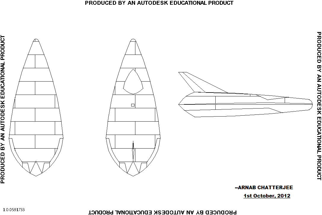
Single reusable spacecraft
National Aeronautics and Space Administration —
Design of a my single person reusable spacecraft. It can carry one person and it has to be dropped from an aircraft at an altitude of 40,000 - 45,000 feet. Can be the... -
Federal
Sounder SIPS: AQUA AIRS IR + MW Level 2: Atmospheric state at Standard Pressure Levels derived from CLIMCAPS V2.1 (SNDRAQIML2PLEVCPS) at GES DISC
National Aeronautics and Space Administration —
The CLIMCAPS (Community Long-term Infrared Microwave Coupled Product System) algorithm is used to analyze data from the AIRS (Atmospheric Infrared Sounder)/AMSU... -
Federal
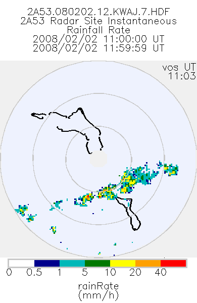
TRMM Ground Validation Radar Site Rain Rate Map L2 1 hour 2 km V7 (TRMM_2A53UW) at GES DISC
National Aeronautics and Space Administration —
This dataset is part of the University of Washington TRMM Ground Validation products. Instantaneous rain rate cartesian grid based on baseUW and 2A54UW. Units are... -
Federal
Sounder SIPS: Suomi NPP CrIMSS Level 3 Comprehensive Quality Control Gridded Daily CHART Normal Spectral Resolution V1
National Aeronautics and Space Administration —
The objective of this limited edition data collection is to examine products generated by the Climate Heritage AIRS Retrieval Technique (CHART) algorithm to analyze...

Official websites use .gov
A
.gov website belongs to an official government
organization in the United States.
Secure .gov websites use HTTPS
A
lock (
) or https:// means you’ve safely connected to
the .gov website. Share sensitive information only on official,
secure websites.