

17 datasets found for ""Reference Grids""
-
Federal
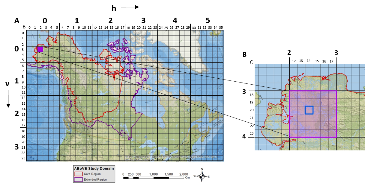
ABoVE: Study Domain and Standard Reference Grids
National Aeronautics and Space Administration —
The Arctic - Boreal Vulnerability Experiment (ABoVE) has developed two standardized spatial data products to expedite coordination of research activities and to... -
Federal
1:6000 Scale (6K) Quadrangles developed by USEPA to Support Reconnaissance, and Tactical and Strategic Planning for Emergency Responses and Homeland Security Events (Region 4 Extract)
U.S. Environmental Protection Agency —
Reference quads for emergency response reconnaissance developed for use by the US Environmental Protection Agency. Grid cells are based on densification of the USGS... -
Federal
1:6000 Scale (6K) Quadrangles developed by USEPA to Support Reconnaissance, and Tactical and Strategic Planning for Emergency Responses and Homeland Security Events (Region 1 Extract)
U.S. Environmental Protection Agency —
Reference quads for emergency response reconnaissance developed for use by the US Environmental Protection Agency. Grid cells are based on densification of the USGS... -
Federal
1:6000 Scale (6K) Quadrangles developed by USEPA to Support Reconnaissance, and Tactical and Strategic Planning for Emergency Responses and Homeland Security Events (Downloadable Data)
U.S. Environmental Protection Agency —
Reference quads for emergency response reconnaissance developed for use by the US Environmental Protection Agency. Grid cells are based on densification of the USGS... -
Federal
1:6000 Scale (6K) Quadrangles developed by USEPA to Support Reconnaissance, and Tactical and Strategic Planning for Emergency Responses and Homeland Security Events (Region 8 Extract)
U.S. Environmental Protection Agency —
Reference quads for emergency response reconnaissance developed for use by the US Environmental Protection Agency. Grid cells are based on densification of the USGS... -
Federal
ABoVE: Study Domain and Standard Reference Grids, Version 2
National Aeronautics and Space Administration —
The Arctic - Boreal Vulnerability Experiment (ABoVE) has developed two standardized spatial data products to expedite coordination of research activities and to... -
Federal
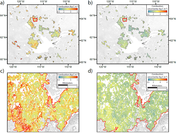
ABoVE: Wildfire Carbon Emissions and Burned Plot Characteristics, NWT, CA, 2014-2016
National Aeronautics and Space Administration —
This dataset provides estimates of wildfire carbon emissions and uncertainties at 30-m resolution, and measurements collected at burned and unburned field plots from... -
Federal
1:6000 Scale (6K) Quadrangles developed by USEPA to Support Reconnaissance, and Tactical and Strategic Planning for Emergency Responses and Homeland Security Events (Region 5 Extract)
U.S. Environmental Protection Agency —
Reference quads for emergency response reconnaissance developed for use by the US Environmental Protection Agency. Grid cells are based on densification of the USGS... -
Federal
1:6000 Scale (6K) Quadrangles developed by USEPA to Support Reconnaissance, and Tactical and Strategic Planning for Emergency Responses and Homeland Security Events (Region 7 Extract)
U.S. Environmental Protection Agency —
Reference quads for emergency response reconnaissance developed for use by the US Environmental Protection Agency. Grid cells are based on densification of the USGS... -
Federal
1:6000 Scale (6K) Quadrangles developed by USEPA to Support Reconnaissance, and Tactical and Strategic Planning for Emergency Responses and Homeland Security Events (Region 6 Extract)
U.S. Environmental Protection Agency —
Reference quads for emergency response reconnaissance developed for use by the US Environmental Protection Agency. Grid cells are based on densification of the USGS... -
Federal
1:6000 Scale (6K) Quadrangles developed by USEPA to Support Reconnaissance, and Tactical and Strategic Planning for Emergency Responses and Homeland Security Events (Region 10 Extract)
U.S. Environmental Protection Agency —
Reference quads for emergency response reconnaissance developed for use by the US Environmental Protection Agency. Grid cells are based on densification of the USGS... -
Federal
1:6000 Scale (6K) Quadrangles developed by USEPA to Support Reconnaissance, and Tactical and Strategic Planning for Emergency Responses and Homeland Security Events (Region 9 Extract)
U.S. Environmental Protection Agency —
Reference quads for emergency response reconnaissance developed for use by the US Environmental Protection Agency. Grid cells are based on densification of the USGS... -
Federal
1:6000 Scale (6K) Quadrangles developed by USEPA to Support Reconnaissance, and Tactical and Strategic Planning for Emergency Responses and Homeland Security Events (Region 2 Extract)
U.S. Environmental Protection Agency —
Reference quads for emergency response reconnaissance developed for use by the US Environmental Protection Agency. Grid cells are based on densification of the USGS... -
Federal
Soil Moisture Active Passive (SMAP) L4 Carbon Ancillary Parameters V001
National Aeronautics and Space Administration —
This ancillary SMAP product contains assorted static ancillary parameters, such as reference grids and land cover classifications, also referred to as Plant Function... -
Federal
Draft 1;6000 Scale (6K) Quadrangles developed by USEPA to Support Reconnaissance, and Tactical and Strategic Planning for Emergency Responses and Homeland Security Events (Region 3 Extract)
U.S. Environmental Protection Agency —
Reference quads for emergency response reconnaissance developed for use by the US Environmental Protection Agency. Grid cells are based on densification of the USGS... -
Federal
Lake Bathymetry Maps derived from Landsat and Random Forest Modeling, North Slope, AK
National Aeronautics and Space Administration —
This dataset provides lake bathymetry maps derived from Landsat surface reflectance products for a portion of the North Slope area of Alaska. A random forest... -
Federal
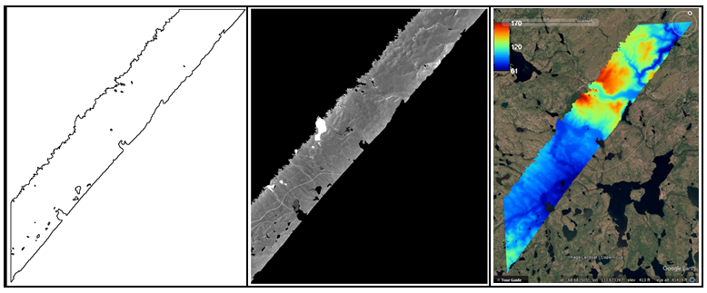
ABoVE: AirSWOT Ka-band Radar over Surface Waters of Alaska and Canada, 2017
National Aeronautics and Space Administration —
This dataset provides AirSWOT (Surface Water and Ocean Topography) Ka-band (35.75 GHz) radar data products collected from an airborne platform over parts of Alaska...
17 datasets found for ""Reference Grids""