
-
Federal
ISLSCP II Global Sea Ice Concentration recent views
National Aeronautics and Space Administration —
This International Satellite Land Surface Climatology Project (ISLSCP) Initiative II data set, ISLSCP II Global Sea Ice Concentration, is based on the Goddard Space... -
Federal
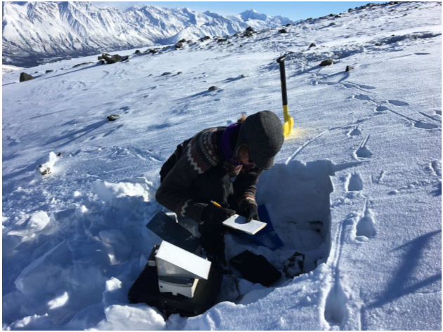
Snow Depth, Stratigraphy, and Temperature in Wrangell St Elias NP, Alaska, 2016-2018 recent views
National Aeronautics and Space Administration —
This dataset includes data from late-March snow surveys and hourly digital camera images from two study areas within the Wrangell St Elias National Park, Alaska.... -
Federal
ABoVE: Rain-on-Snow Frequency and Distribution during Cold Seasons, Alaska, 2003-2016 NGDA recent views
National Aeronautics and Space Administration —
This dataset provides maps of rain-on-snow (ROS) events across Alaska for the individual months of November to March 2002-2011 and November to March 2012-2016, and... -
Federal
Snow Properties and Wildlife Tracks in Washington and Alaska recent views
National Aeronautics and Space Administration —
This dataset contains three field seasons of snow-wildlife observations conducted at 707 sites from January 2021 to March 2023 in Washington and Alaska, spanning a... -
Federal
BOREAS RSS-17 1994 ERS-1 Level-3 Freeze/Thaw Backscatter Change Images recent views
National Aeronautics and Space Administration —
The BOREAS RSS-17 team acquired and analyzed imaging radar data from the ESA's ERS-1 over a complete annual cycle at the BOREAS sites in Canada in 1994 to detect... -
Federal
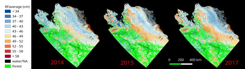
ABoVE: Upscaled Active Layer Thickness in Northern Alaska, 2014-2017 recent views
National Aeronautics and Space Administration —
The dataset consists of maps of estimated Active Layer Thickness (ALT) at 30-m resolution throughout the northern half of Alaska for the years 2014, 2015, and 2017.... -
Federal
SISTER: Experimental Workflows, Product Generation Environment, and Sample Data, V004 recent views
National Aeronautics and Space Administration —
The Space-based Imaging Spectroscopy and Thermal pathfindER (SISTER) activity originated in support of the NASA Earth System Observatory's Surface Biology and Geology... -
Federal
BOREAS AES Five-day Averaged Surface Meteorological and Upper Air Data recent views
National Aeronautics and Space Administration —
Contains 5-day averages of hourly and daily data from 23 meteorological stations across Canada along with full-resolution upper air measurements from 1 station in The... -
Federal
BOREAS Follow-On DSP-04 1994 ERS-1 Level-4 Landscape Freeze/Thaw Maps, Ver. 1.0 recent views
National Aeronautics and Space Administration —
The BOREAS DSP-4 team acquired and analyzed imaging radar data from the ESA's ERS-1 over a complete annual cycle at the BOREAS sites in Canada in 1994 to detect... -
Federal
Projections of Permafrost Thaw and Carbon Release for RCP 4.5 and 8.5, 1901-2299 recent views
National Aeronautics and Space Administration —
This dataset consists of an ensemble of model projections from 1901 to 2299 for the northern hemisphere permafrost domain. The model projections include monthly... -
Federal
Daily SnowModel Outputs Covering the ABoVE Core Domain, 3-km Resolution, 1980-2020 recent views
National Aeronautics and Space Administration —
This dataset provides daily SnowModel simulation outputs on a 3-km grid for the period 1 September 1980 through 31 August 2020, covering the Core ABoVE Domain. The... -
Federal
BOREAS Derived Surface Meteorological Data recent views
National Aeronautics and Space Administration —
Contains surface meteorology data merged/interpolated from four BOREAS sites for the years 1994, 1995, and 1996. -
Federal
Pre-ABoVE: Ground-penetrating Radar Measurements of ALT on the Alaska North Slope recent views
National Aeronautics and Space Administration —
This data set includes estimates of permafrost Active Layer Thickness (ALT; cm), and calculated uncertainties, derived using a ground-penetrating radar (GPR) system... -
Federal
BOREAS RSS-08 BIOME-BGC Model Simulations at Tower Flux Sites in 1994 recent views
National Aeronautics and Space Administration —
BIOME-BGC is a general ecosystem process model designed to simulate biogeochemical and hydrologic processes across multiple scales. BIOME-BGC is used to estimate... -
Federal
ABoVE: CO2 and CH4 Fluxes and Meteorology at Flux Tower Sites, Alaska, 2015-2017 recent views
National Aeronautics and Space Administration —
This dataset provides CO2 and CH4 fluxes and meteorological parameters from five eddy covariance (EC) tower sites located at Barrow (three sites), Atqasuk (ATQ) and... -
Federal
CARVE: Daily Thaw State of Boreal and Arctic Alaska from AMSR-E and SSM/I, 2003-2014 recent views
National Aeronautics and Space Administration —
This data set provides daily 10 km resolution maps of the Alaskan and Arctic Boreal land surface state as either frozen, melting, or thawed. These data are generated... -
Federal
BOREAS RSS-08 Snow Maps Derived from Landsat TM Imagery recent views
National Aeronautics and Space Administration —
The BOREAS RSS-08 team utilized Landsat TM images to perform mapping of snow extent over the SSA. This data set consists of two Landsat TM images which were used to... -
Federal
Lund-Potsdam-Jena Wetland Hydrology and Methane DGV Model (LPJ-WHyMe v1.3.1) recent views
National Aeronautics and Space Administration —
This model product provides the Fortran 77 source code for the Lund-Potsdam-Jena (LPJ) Wetland Hydrology and Methane Dynamic Global Vegetation Model (LPJ-WHyMe... -
Federal
ABoVE: Dall Sheep Track Sinking Depths, Snow Depth, Hardness, and Density, 2017 recent views
National Aeronautics and Space Administration —
This dataset contains Dall sheep (Ovis dalli dalli) hoof sinking depths in snow tracks, and snow depth, hardness, and density measurements in snow pits adjacent to... -
Federal
ABoVE: Active Layer Thickness from Airborne L- and P- band SAR, Alaska, 2017, Ver. 3 recent views
National Aeronautics and Space Administration —
This dataset provides estimates of seasonal subsidence, active layer thickness (ALT), the vertical soil moisture profile, and uncertainties at a 30 m resolution for...

Official websites use .gov
A
.gov website belongs to an official government
organization in the United States.
Secure .gov websites use HTTPS
A
lock (
) or https:// means you’ve safely connected to
the .gov website. Share sensitive information only on official,
secure websites.