
-
Federal
BOREAS RSS-08 SSA IFC-3 Digitized Stereo Imagery at the OBS, OA, and OJP Sites
National Aeronautics and Space Administration —
The RSS08 team acquired stereo photography from the double-scaffold towers at the Southern Study Area (SSA) Old Black Spruce (OBS), Old Aspen (OA), and Old Jack Pine... -
Federal
Automated Greenland Glacier Termini Position Time Series, Version 1
National Aeronautics and Space Administration —
This data set contains shapefiles of termini traces from 294 Greenland glaciers, derived using a deep learning algorithm (AutoTerm) applied to satellite imagery. The... -
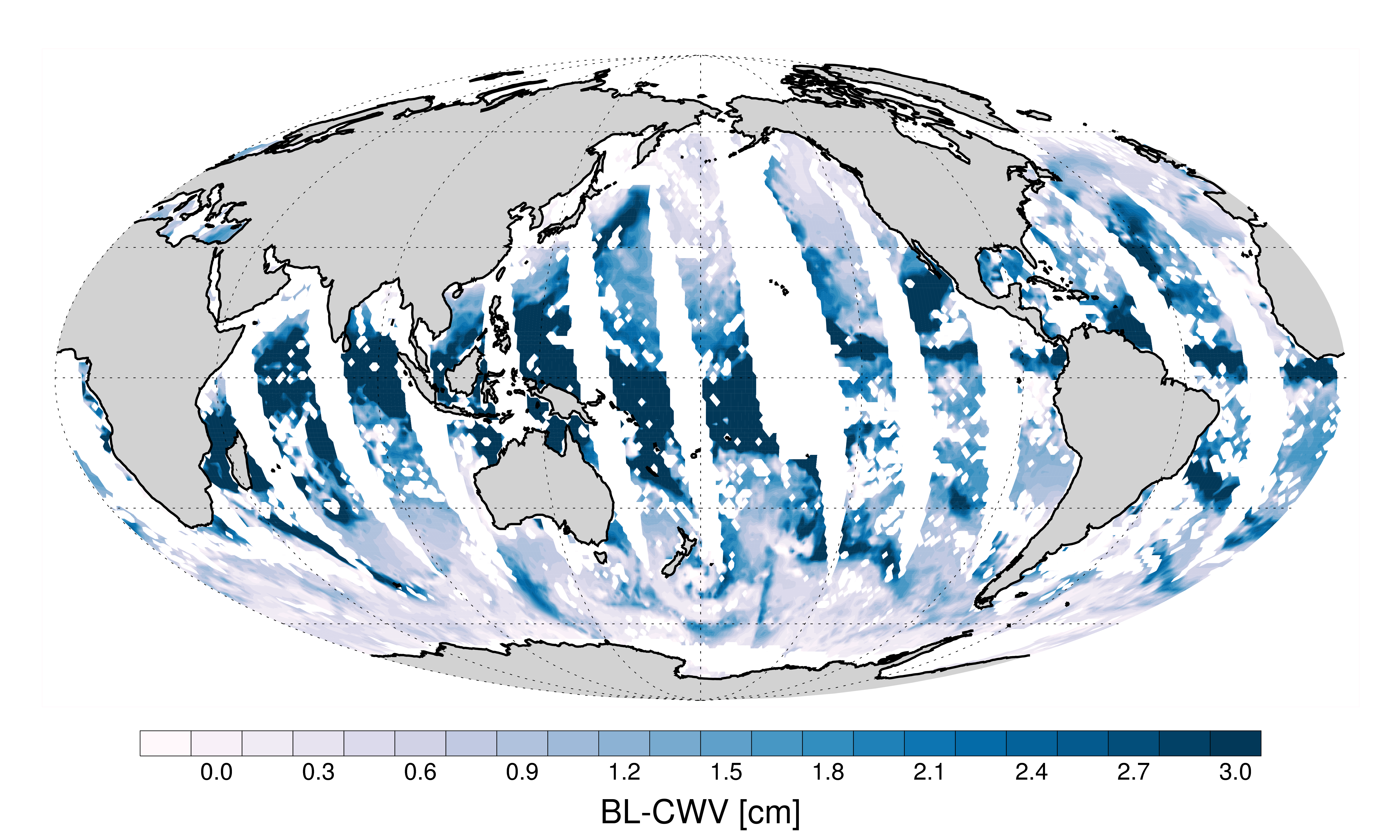
Federal
AMSR-MODIS Boundary Layer Water Vapor L3 Daily 1 degree x 1 degree V1 (AMDBLWV) at GES DISC
National Aeronautics and Space Administration —
This data set provides an estimate the marine boundary layer water vapor beneath uniform cloud fields. Microwave radiometry from AMSR-E and AMSR-2 provides the total... -
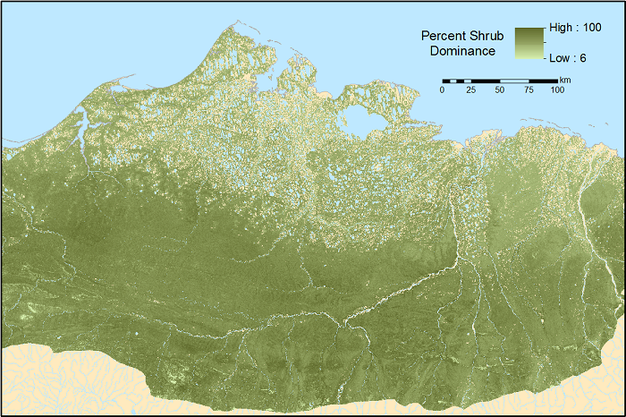
Federal
ABoVE: Gridded 30-m Aboveground Biomass, Shrub Dominance, North Slope, AK, 2007-2016
National Aeronautics and Space Administration —
This dataset includes 30-m gridded estimates of total plant aboveground biomass (AGB), the shrub AGB, and the shrub dominance (shrub/plant AGB) for non-water portions... -
Federal
CAMEX-4 ER-2 MODIS AIRBORNE SIMULATOR (MAS) V1
National Aeronautics and Space Administration —
The MODIS Airborne Simulator (MAS) is an airborne scanning spectrometer that acquires high spatial resolution imagery of cloud and surface features from its vantage... -
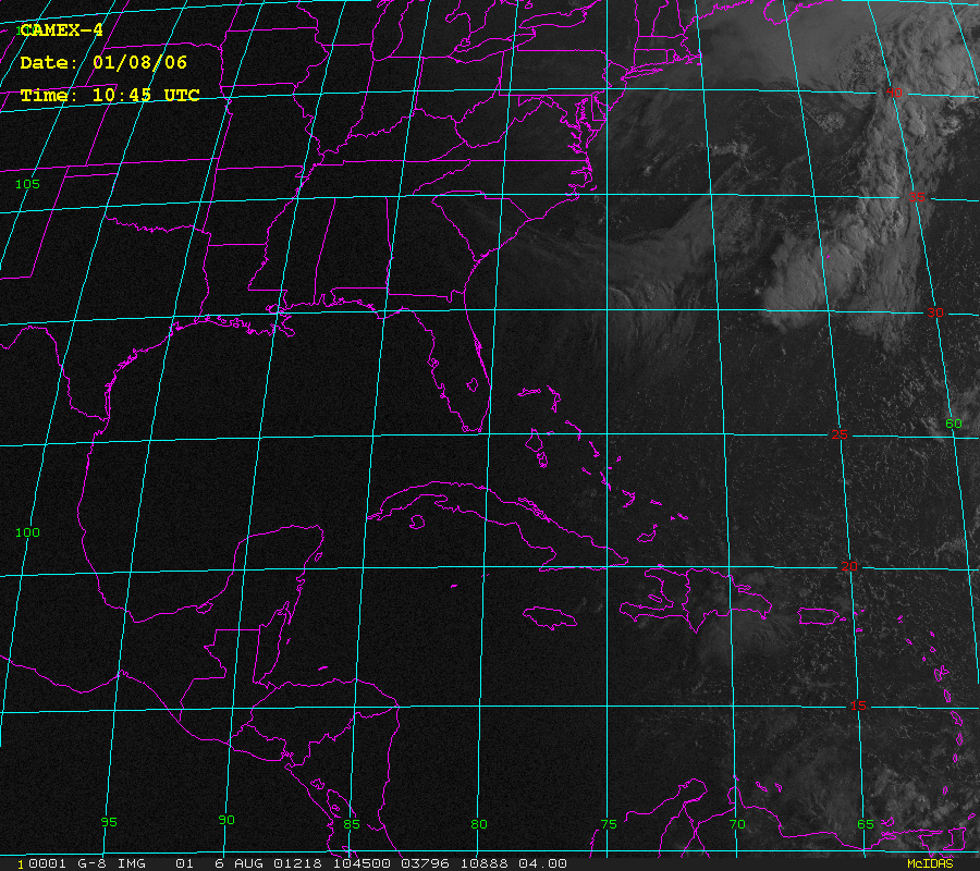
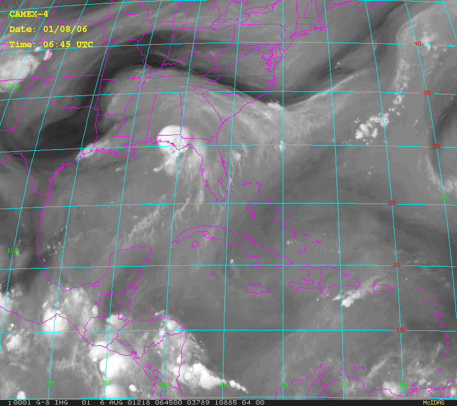
Federal
CAMEX-4 GOES-8 PRODUCTS V1
National Aeronautics and Space Administration —
The CAMEX-4 GOES-8 Products dataset was collected during the CAMEX-4 field campaign, which ocused on the study of tropical cyclone (hurricane) development, tracking,... -
Federal
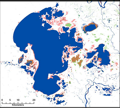
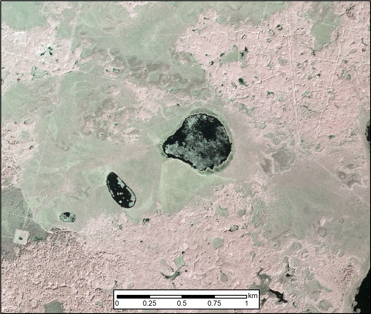
ABoVE: Surface Water Extent, Boreal and Tundra Regions, North America, 1991-2011
National Aeronautics and Space Administration —
This data set provides the location and extent of surface water (open water not including vegetated wetlands) for the entire Boreal and Tundra regions of North... -
Federal
ABoVE: Burn Severity of Soil Organic Matter, Northwest Territories, Canada, 2014-2015
National Aeronautics and Space Administration —
This dataset provides maps at 30-m resolution of landscape surface burn severity (surface litter and soil organic layers) from the 2014-2015 fires in the Northwest... -
Federal
ABoVE: AVIRIS-NG Imaging Spectroscopy for Alaska, Canada, and Iceland, 2017-2022, V3
National Aeronautics and Space Administration —
This dataset supersedes the previously published ABoVE AVIRIS-NG Level 2 surface reflectance files for 2017-2019 surveys of Alaska and northwestern Canada. It also... -
Federal
ABoVE: Burned Area, Depth, and Combustion for Alaska and Canada, 2001-2019
National Aeronautics and Space Administration —
This dataset provides annual gridded estimates of fire locations and associated burn fraction per pixel for Alaska and Canada at approximately 500 m spatial... -
Federal
AMSR-MODIS Boundary Layer Water Vapor L3 Monthly 1 degree x 1 degree V1 (AMMBLWV) at GES DISC
National Aeronautics and Space Administration —
This data set provides an estimate the marine boundary layer water vapor beneath uniform cloud fields. Microwave radiometry from AMSR-E and AMSR-2 provides the total... -
Federal
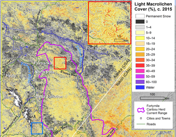
ABoVE: Lichen Forage Cover over Fortymile Caribou Range, Alaska and Yukon, 2000-2015
National Aeronautics and Space Administration —
This dataset provides modeled estimates of lichen ground cover at 30 m resolution across the Fortymile study area in interior eastern Alaska, U.S., and the Yukon... -
Federal
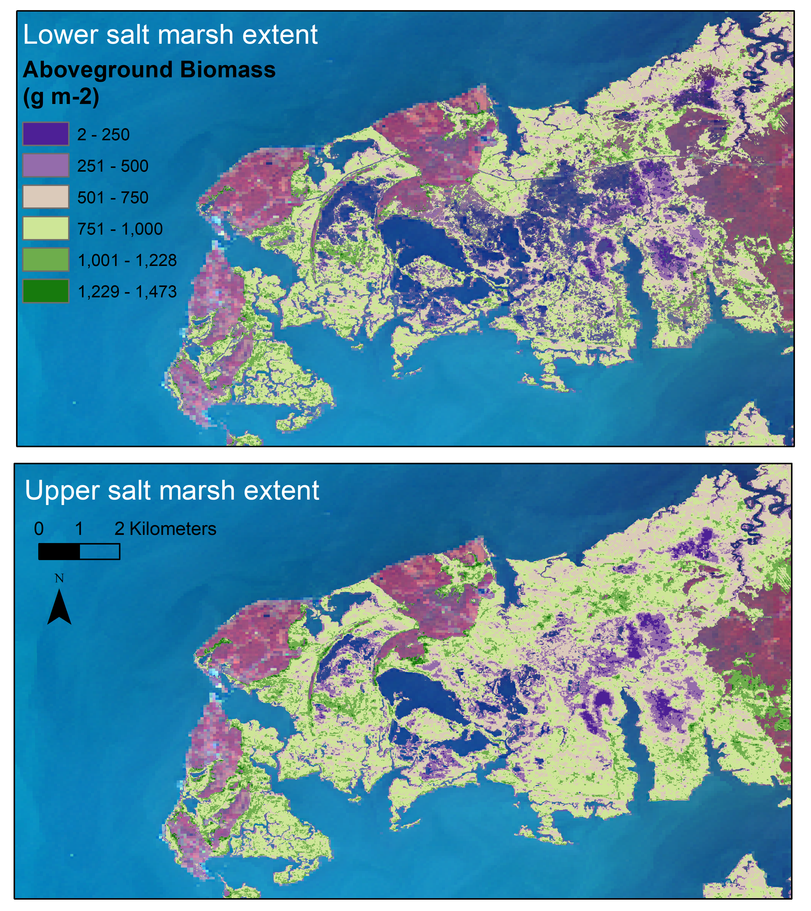
Aboveground Biomass Estimates for Salt Marsh for the Contiguous United States, 2020
National Aeronautics and Space Administration —
This dataset provides estimates of aboveground biomass (AGB) and salt marsh extent in the contiguous United States for 2020 and includes all coastal watersheds across... -
Federal
ABoVE: Peak Greenness for Canadian Boreal Forest from Landsat 5 TM Imagery, 1984-2011
National Aeronautics and Space Administration —
This dataset provides a 28-year time series of peak greenness (NDVI) data derived from Landsat 5 TM imagery over the boreal forest region of Canada. Landsat 5 TM... -
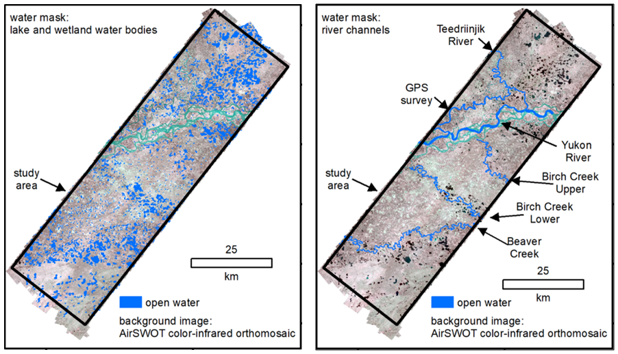
Federal
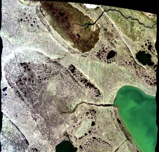
ABoVE: AirSWOT Radar, Orthomosaic, and Water Masks, Yukon Flats Basin, Alaska, 2015
National Aeronautics and Space Administration —
This dataset provides NASA AirSWOT Ka-band (35.75 GHz) radar interferometry data products for water surface elevation (WSE), a derived color-infrared (CIR) digital... -
Federal
ABoVE: AirSWOT Color-Infrared Imagery Over Alaska and Canada, 2017
National Aeronautics and Space Administration —
This dataset contains georeferenced three-band orthomosaics of green, red, and near-infrared (NIR) digital imagery at 1m resolution collected over selected surface... -
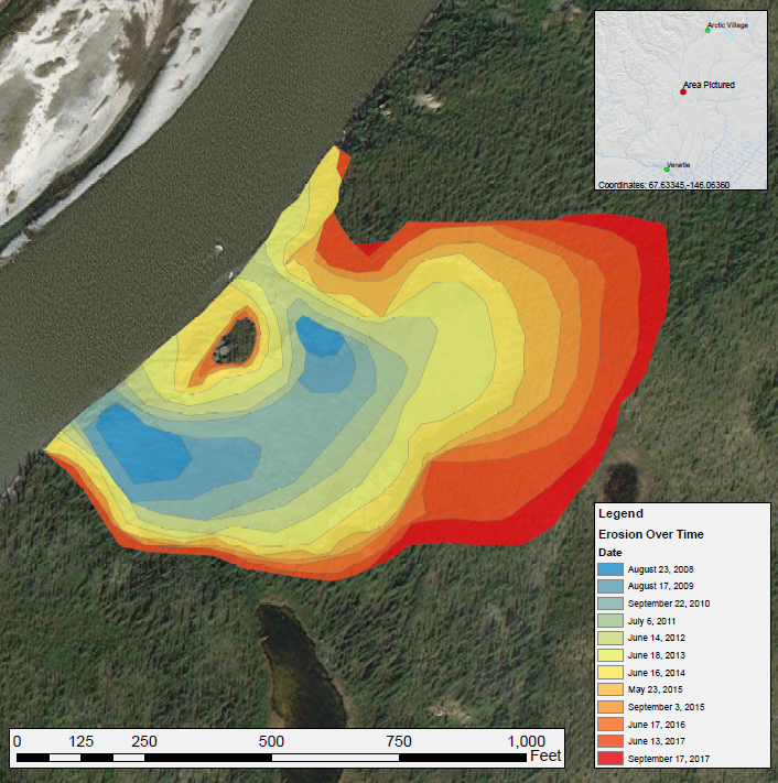
Federal
ABoVE: Annual Thaw Slump Expansion on East Fork Chandalar River, Alaska, 2008-2017
National Aeronautics and Space Administration —
This dataset provides a time series of spatial data showing the expansion of a thaw slump on the East Fork Chandalar River near the community of Venetie, Alaska, from... -
Federal
BOREAS RSS-20 POLDER C-130 Measurements of Surface BRDF
National Aeronautics and Space Administration —
This data set contains measurements of surface BRDF made by the POLDER instrument over several surface types (pine, spruce, fen) of the BOREAS SSA during the 1994... -
Federal
BOREAS RSS-18 Level 1B AVIRIS At-Sensor Radiance Imagery
National Aeronautics and Space Administration —
This dataset holds Level 1B (L1B) radiance data collected by the AVIRIS-Classic instrument near Prince Albert, Saskatchewan, Canada, on August 14, 1996. This imagery...

Official websites use .gov
A
.gov website belongs to an official government
organization in the United States.
Secure .gov websites use HTTPS
A
lock (
) or https:// means you’ve safely connected to
the .gov website. Share sensitive information only on official,
secure websites.