
-
Federal
Suomi-NPP VIIRS Global Mapped Inherent Optical Properties (IOP) - Near Real-time (NRT) Data, version R2022.0
National Aeronautics and Space Administration —
The Ocean Biology DAAC produces near real-time (quicklook) products using the best-available combination of ancillary data from meteorological and ozone data. As... -
Federal
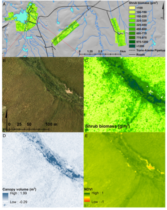
High-Resolution Shrub Biomass and Uncertainty Maps, Toolik Lake Area, Alaska, 2013
National Aeronautics and Space Administration —
This dataset contains estimates for aboveground shrub biomass and uncertainty at high spatial resolution (0.80-m) across three research areas near Toolik Lake,... -
Federal
Suomi-NPP VIIRS Regional Inherent Optical Properties (IOP) - Near Real-time (NRT) Data, version R2022.0
National Aeronautics and Space Administration —
The Ocean Biology DAAC produces near real-time (quicklook) products using the best-available combination of ancillary data from meteorological and ozone data. As... -
Federal
ENVISAT MERIS Global Mapped Inherent Optical Properties (IOP) Data, version R2022.0
National Aeronautics and Space Administration —
MERIS (Medium Resolution Imaging Spectrometer) is a programmable, medium-spectral resolution, imaging spectrometer operating in the solar reflective spectral range.... -
Federal
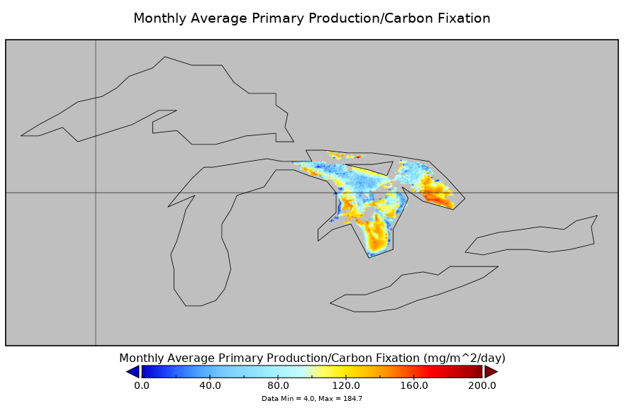
Carbon Monitoring System Lake Huron Primary Production Monthly V1 (CMSLakeHuronPPM) at GES DISC NGDA
National Aeronautics and Space Administration —
Monthly Average primary production/carbon fixation data for Lake Huron. The primary production data is derived using MODIS imagery with model data. The NASA Carbon... -
Federal
Gross Primary Production Maps of Tidal Wetlands across Conterminous USA, 2000-2019 NGDA
National Aeronautics and Space Administration —
This dataset provides mapped tidal wetland gross primary production (GPP) estimates (g C/m2/day) derived from multiple wetland types at 250-m resolution across the... -
Federal
Visible Infrared Imager-Radiometer Suite NPP Level-2 Normalized Difference Vegetation Index Land Reflectance Data Version 2014
National Aeronautics and Space Administration —
Product Title: Visible Infrared Imager-Radiometer Suite NPP Level-2 The Visible and Infrared Imager/Radiometer Suite (VIIRS) is a multi-disciplinaryinstrument that is... -
Federal
NAFD-ATT Forest Canopy Cover Loss from Landsat, CONUS, 1986-2010
National Aeronautics and Space Administration —
Characterizing the cause of forest canopy changes through time is fundamental to understanding current and future forest functions. A better understanding of forest... -
Federal
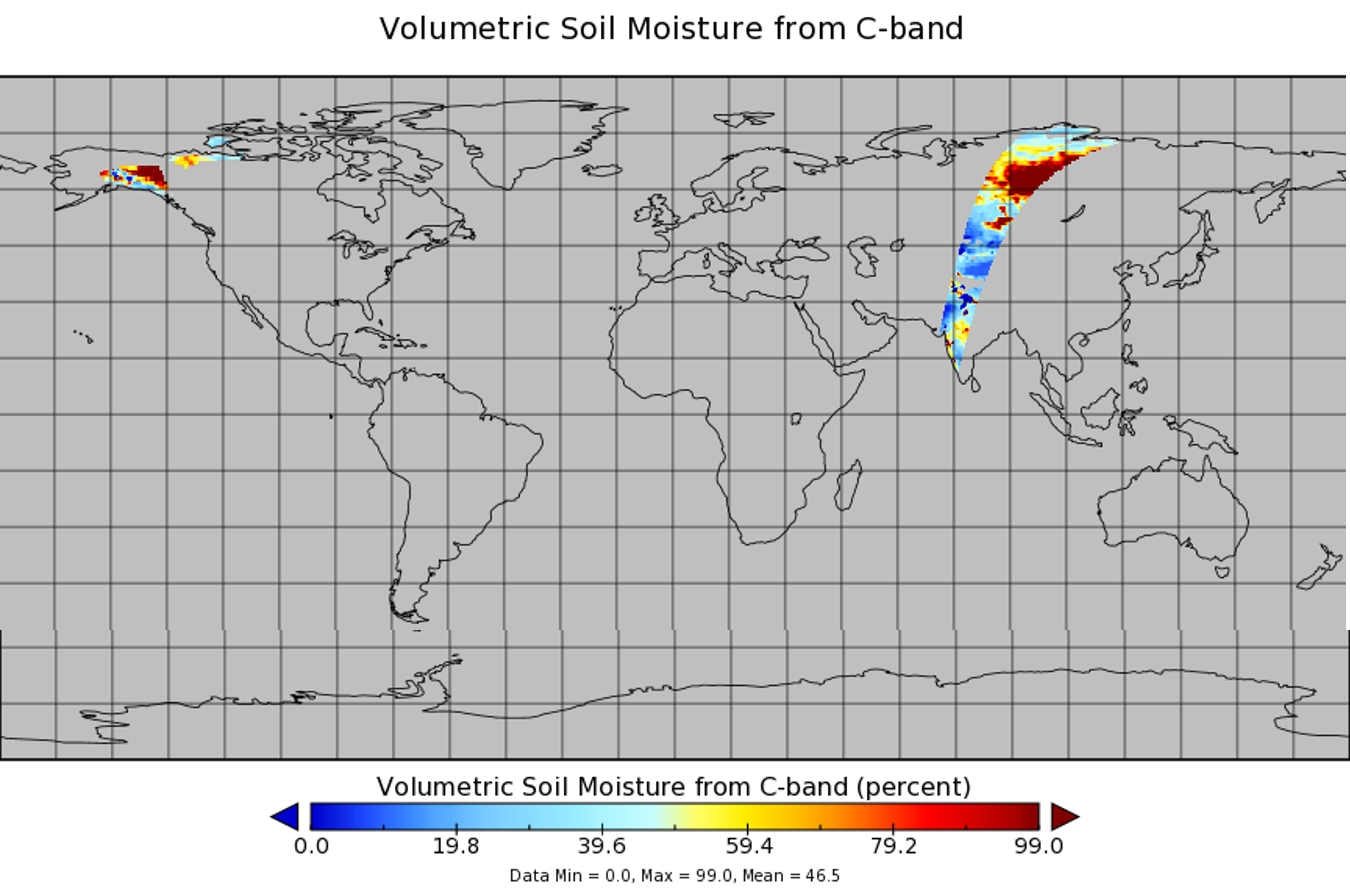
WindSat/Coriolis surface soil moisture (LPRM) L2 V001 (LPRM_WINDSAT_SOILM2) at GES DISC
National Aeronautics and Space Administration —
WindSat/Coriolis surface soil moisture (LPRM) L2 V001 is a Level 2 (swath) data set. Its land surface parameters, surface soil moisture, land surface (skin)... -
Federal
OrbView-2 SeaWiFS Global Mapped Inherent Optical Properties (IOP) Data, version R2022.0
National Aeronautics and Space Administration —
The SeaWiFS instrument was launched by Orbital Sciences Corporation on the OrbView-2 (a.k.a. SeaStar) satellite in August 1997, and collected data from September 1997... -
Federal
Delta-X: AirSWOT L2 Geocoded Water Surface Elevation, MRD, Louisiana, 2021, Version 2
National Aeronautics and Space Administration —
This dataset contains Level 2 (L2) AirSWOT geocoded products, including estimated water surface elevation. The AirSWOT instrument is a Ka-band interferometer and for... -
Federal
ABoVE: Needle-Level Chlorophyll Fluorescence, Alaska and Idaho, USA, 2017 and 2019
National Aeronautics and Space Administration —
This dataset provides the results of in situ measurements of needle-level chlorophyll fluorescence (ChlF) obtained from a pulse amplitude modulated (PAM) fluorometer... -
Federal
Suomi-NPP VIIRS Global Mapped Inherent Optical Properties (IOP) Data, version R2022.0
National Aeronautics and Space Administration —
The Visible and Infrared Imager/Radiometer Suite (VIIRS) is a multi-disciplinary instrument that is being flown on the Joint Polar Satellite System (JPSS) series of... -
Federal
Arctic Vegetation Plots for IBP Tundra Biome, Barrow, Alaska, 1972-2010
National Aeronautics and Space Administration —
This data set provides vegetation cover and environmental plot data collected as part of the International Biological Program (IBP), U. S. Tundra Biome Program, in... -
Federal
ABoVE: Reflectance Spectra of Tundra Plant Communities across Northern Alaska
National Aeronautics and Space Administration —
This dataset reports full-spectrum (350-2500 nm) reflectance measurements of diverse plant communities at the plot-level and individual plant species at the leaf-... -
Federal
Terra MODIS Global Binned Inherent Optical Properties (IOP) Data, version R2022.0 NGDA
National Aeronautics and Space Administration —
MODIS (or Moderate-Resolution Imaging Spectroradiometer) is a key instrument aboard the Terra (EOS AM) and Aqua (EOS PM) satellites. Terra's orbit around the Earth is... -
Federal
NPP Grassland: Kurukshetra, India, 1970-1971, R1
National Aeronautics and Space Administration —
This data set contains two ASCII files (.txt format). One file contains above- and below-ground biomass (including standing dead material and litter) and productivity... -
Federal
Arctic Vegetation Plots at Toolik Lake, Alaska, 1989
National Aeronautics and Space Administration —
This dataset provides environmental, soil, and vegetation data collected in August 1989 from 81 study plots at the Toolik Lake research site, located in the southern... -
Federal
SMEX02 Soil Moisture Atmosphere Coupling Experiment (SMACEX), Iowa, Version 1
National Aeronautics and Space Administration —
This data set contains measurements collected from flights conducted in June and July 2002 over the Walnut Creek watershed in central Iowa, USA. -
Federal
LBA-ECO TG-07 Ground-based Biometry Data at km 83 Site, Tapajos National Forest: 1997
National Aeronautics and Space Administration —
A field inventory of trees was conducted in March of 1997 in a logging concession at the Tapajos National Forest, south of Santarem, Para, Brazil. The inventory was...

Official websites use .gov
A
.gov website belongs to an official government
organization in the United States.
Secure .gov websites use HTTPS
A
lock (
) or https:// means you’ve safely connected to
the .gov website. Share sensitive information only on official,
secure websites.