
-
Federal
Export and Leaching of Carbon and Nitrogen from Mississippi River Basin, 1901-2099
National Aeronautics and Space Administration —
This dataset provides estimates for export and leaching of dissolved inorganic carbon (DIC), dissolved organic carbon (DOC), total organic carbon (TOC), particulate... -
Federal
Shared Socioeconomic Pathways (SSPs) Literature Database, v1, 2014-2019
National Aeronautics and Space Administration —
The Shared Socioeconomic Pathways (SSPs) Literature Database, v1, 2014-2019 consists of biographic information, abstracts, and analysis of 1,360 articles published... -
Federal
CMS: Forest Carbon Stocks, Emissions, and Net Flux for the Conterminous US: 2005-2010
National Aeronautics and Space Administration —
This data set provides maps of estimated carbon in forests of the 48 continental states of the US for the years 2005-2010. Carbon (termed committed carbon) stocks... -
Federal
LBA-ECO CD-11 Biophysical Measurements of Logged and Fire-Treated Forests, Brazil
National Aeronautics and Space Administration —
This data set reports the results of vegetation field surveys that measured tree height and diameter at breast height (DBH) in defined size classes at three study... -
Federal
SAFARI 2000 1-Degree Estimates of Burned Biomass, Area, and Emissions, 2000 NGDA
National Aeronautics and Space Administration —
A new method is used to generate spatial estimates of monthly averaged biomass burned area and spatial and temporal estimates of trace gas and aerosol emissions from... -
Federal
SAFARI 2000 MODIS 500-m Burned Area Products, Southern Africa, Dry Season 2000 NGDA
National Aeronautics and Space Administration —
The SAFARI 2000 project was selected as the first regional test for a prototype regional 500 m MODIS burned area product. The MODIS burned area product maps the 500 m... -
Federal
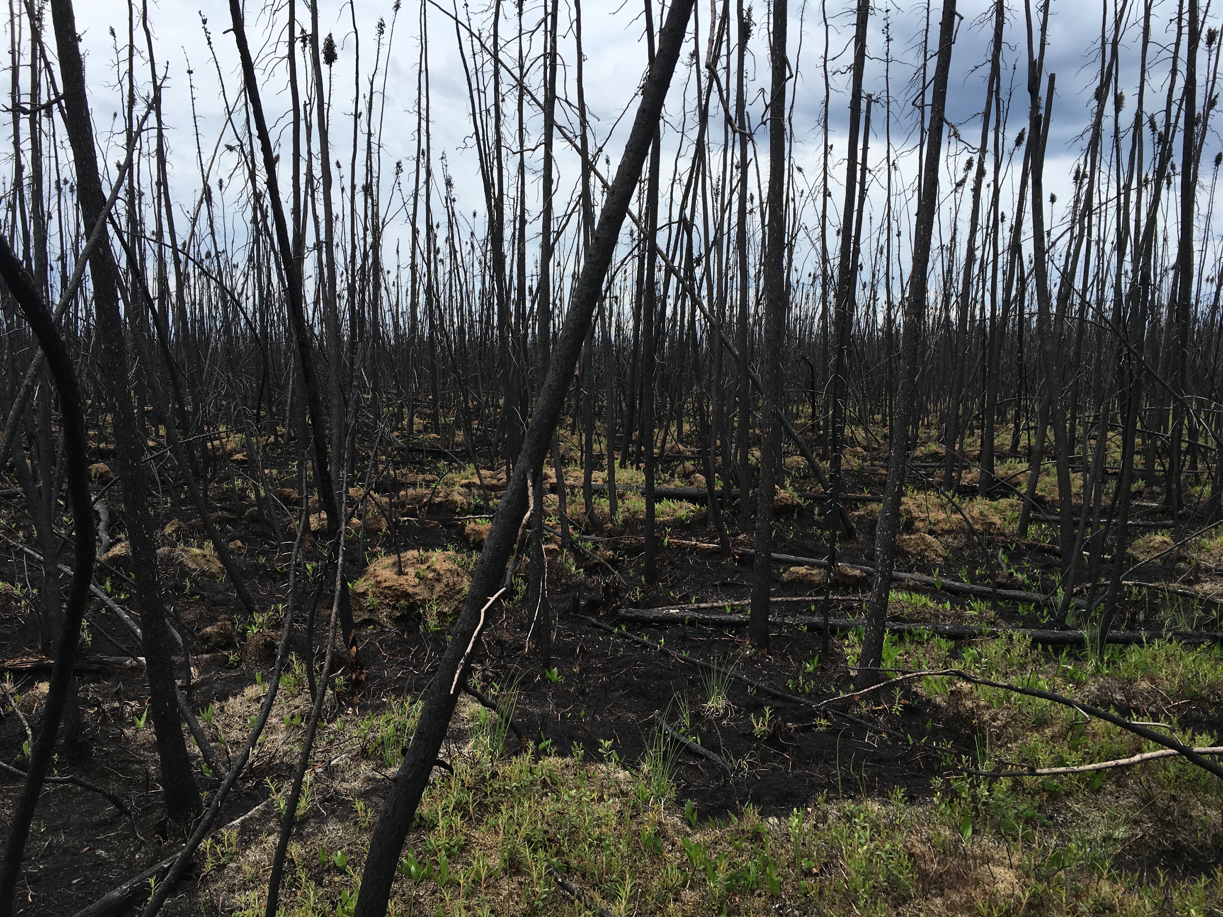
ABoVE: Characterization of Burned and Unburned Boreal Forest Stands, SK, Canada, 2016
National Aeronautics and Space Administration —
This dataset provides the results of field measurements and estimates of carbon stocks and combustion rates that characterize burned and unburned southern boreal... -
Federal
ISLSCP II Global Gridded Gross Domestic Product (GDP), 1990 NGDA
National Aeronautics and Space Administration —
The data sets in this directory were provided by Mr. Gregory Yetman and Drs. Stuart Gaffin and Deborah Balk from the Center for International Earth Science... -
Federal
Geoecology: County-Level Environmental Data for the United States, 1941-1981
National Aeronautics and Space Administration —
The Geoecology database is a compilation of environmental data for the period 1941 to 1981. The Geoecology database contains selected data on terrain and soils, water... -
Federal
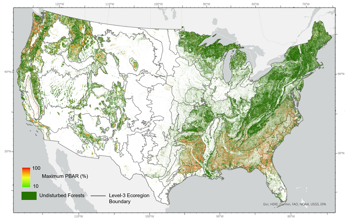
NACP NAFD Project: Forest Disturbance Intensity for CONUS from Landsat, 1986-2015
National Aeronautics and Space Administration —
This dataset contains estimates of forest disturbance intensity for the conterminous United States from 1986 to 2015. It quantifies the severity/intensity of forest... -
Federal
ABoVE: Characterization of Burned and Unburned Spruce Forest Sites, Tanana, AK, 2017
National Aeronautics and Space Administration —
This dataset provides the results of field observations of soil characteristics and depth to permafrost, survey results for Composite Burn Index (CBI) determination,... -
Federal
SAFARI 2000 Emissions Estimates, MODIS Burned Area Product, Dry Season 2000 NGDA
National Aeronautics and Space Administration —
The recently generated MODIS burned area product over southern Africa for the month of September 2000 was used to calculate regional biomass burning emissions from... -
Federal
Committee on Earth Observation Satellites (CEOS) International Directory Portal
National Aeronautics and Space Administration —
The CEOS IDN is an international effort developed to assist researchers in locating information on available datasets and services. The directory is sponsored as a... -
Federal
LBA-ECO CD-04 Logging Damage, km 83 Tower Site, Tapajos National Forest, Brazil
National Aeronautics and Space Administration —
This data set contains the results of a survey of logging damage in a 18 ha plot (300 m N-S, 600 m E-W) east (upwind) of the eddy flux tower at km 83, Tapajos... -
Federal
LBA-ECO LC-13 GIS Coverages of Logged Areas, Cauaxi, Para, Brazil: 1996, 1998
National Aeronautics and Space Administration —
This data set contains GIS coverage constructed from measurements taken of four logged areas in Cauaxi, Para, Brazil. Logged areas were selectively harvested either... -
Federal
Archived SAFARI 2000 Project Website, October 2008
National Aeronautics and Space Administration —
This dataset contains an archived copy of the Safari 2000 Project website as of October 2008. This archived website is provided for informational purposes only. No... -
Federal
LBA-ECO LC-23 Characterization of Vegetation Fire Dynamics for Brazil: 2001-2003 NGDA
National Aeronautics and Space Administration —
Satellite fire detection was determined from two sensors, the Advanced Very High Resolution Radiometer (AVHRR) on NOAA-12 and the Moderate Resolution Imaging... -
Federal
LBA-ECO ND-11 Regeneration in Undisturbed and Logged Forests, NW Mato Grosso, Brazil
National Aeronautics and Space Administration —
This data set reports the results of field surveys to determine: regeneration diversity and size distribution of plants in primary undisturbed forest; and... -
Federal
LBA-ECO LC-13 GIS Coverages of Logged Areas, Tapajos Forest, Para, Brazil: 1996, 1998
National Aeronautics and Space Administration —
This data set contains GIS coverages constructed from measurements taken of logged areas in the Tapajos National Forest region of Para, Brazil in 1996 and 1998 (Asner... -
Federal
Remote Sensing Derived Topsoil and Agricultural Economic Losses, Midwestern USA
National Aeronautics and Space Administration —
This dataset provides estimates of topsoil loss and economic loss associated with decreased crop productivity resulting from topsoil loss at county- and state-levels...

Official websites use .gov
A
.gov website belongs to an official government
organization in the United States.
Secure .gov websites use HTTPS
A
lock (
) or https:// means you’ve safely connected to
the .gov website. Share sensitive information only on official,
secure websites.