
-
Federal
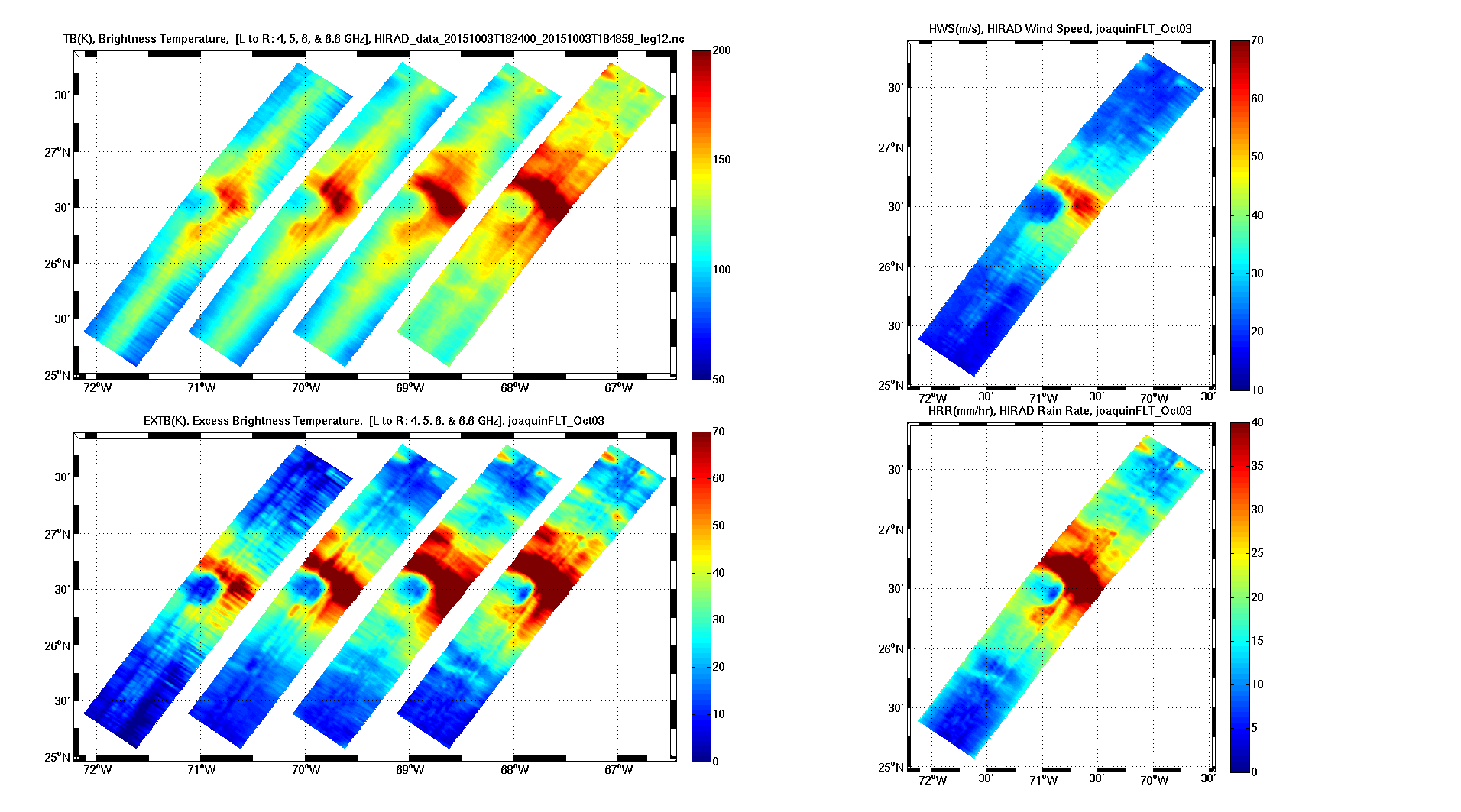
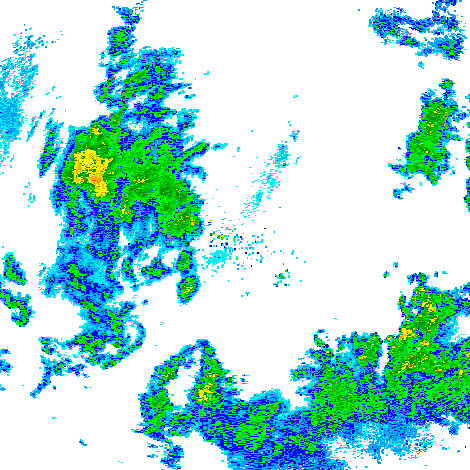
Tropical Cyclone Intensity (TCI) Hurricane Imaging Radiometer (HIRAD) V2.1 recent views
National Aeronautics and Space Administration —
The Tropical Cyclone Intensity (TCI) Hurricane Imaging Radiometer (HIRAD) dataset was created for the TCI field campaign from August 30, 2015 through October 23,... -
Federal
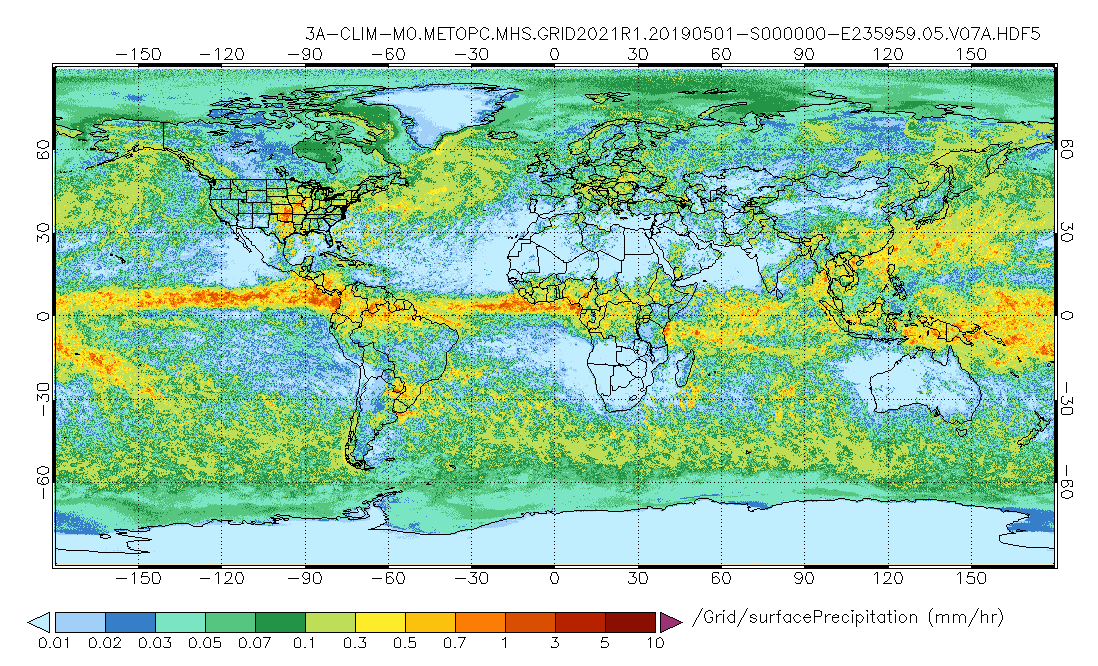
GPM MHS on METOP-C (GPROF) Climate-based Radiometer Precipitation Profiling L3 1 month 0.25 degree x 0.25 degree V07 (GPM_3GPROFMETOPCMHS_CLIM) at GES DISC recent views
National Aeronautics and Space Administration —
Version 07 is the current version of the data set. Older versions are no longer available and have been superseded by Version 07. The "CLIM" products differ from... -
Federal
LUH2-ISIMIP2b Harmonized Global Land Use for the Years 2015-2100 recent views
National Aeronautics and Space Administration —
This dataset provides 0.25-degree gridded, global, annual estimates of fractional land use and land cover patterns for the period 2015-2100, designed to support the... -
Federal
HIRDLS/Aura Level 3 Geopotential Height 1deg Lat Zonal Fourier Coefficients V007 (H3ZFCGPH) at GES DISC recent views
National Aeronautics and Space Administration —
The "HIRDLS/Aura Level 3 Geopotential Height Zonal Fourier Coefficients" version 7 data product (H3ZFCGPH) contains the entire mission (~3 years) of HIRDLS data... -
Federal
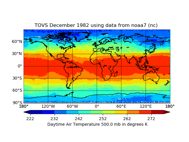
TOVS GLA MONTHLY GRIDS from NOAA-7 02 (TOVSAMNC) at GES DISC recent views
National Aeronautics and Space Administration —
This dataset (TOVSAMNC) contains the TIROS Operational Vertical Sounder (TOVS) level 3 geophysical parameters derived using data from NOAA-7 and the physical... -
Federal
GPM SSMI on F10 (GPROF) Climate-based Radiometer Precipitation Profiling L3 1 month 0.25 degree x 0.25 degree V07 (GPM_3GPROFF10SSMI_CLIM) at GES DISC recent views
National Aeronautics and Space Administration —
Version 7 is the current version of the data set. Older versions will no longer be available and have been superseded by the current version. The "CLIM" products... -
Federal
GPM GROUND VALIDATION COMPOSITE SATELLITE OVERPASSES GCPEX V1 recent views
National Aeronautics and Space Administration —
The GPM Ground Validation Composite Satellite Overpasses GCPEx dataset provides satellite overpasses from the Special Sensor Microwave Imager/Sounder (SSMIS)... -
Federal
GPM GROUND VALIDATION NEXRAD LEVEL II KDVN IFLOODS V1 recent views
National Aeronautics and Space Administration —
The GPM Ground Validation Next Generation Weather Radar (NEXRAD) Level II IFloodS datasets were collected from four sites (see Table 1) from March 29, 2013 to June... -
Federal
Explorer-7 Thermal Radiation Experiment Selected White Sensor Temperature (Nighttime) Values V001 (EXP7L1TRTWHT) at GES DISC recent views
National Aeronautics and Space Administration —
Explorer-7 Thermal Radiation Experiment Selected White Sensor Temperature (Nighttime) Values product contains the temperatures measured by the white sensor at night.... -
Federal
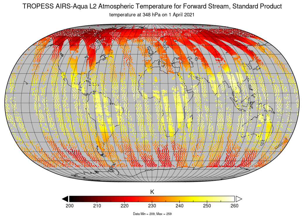
TROPESS AIRS-Aqua L2 Atmospheric Temperature for Forward Stream, Standard Product V1 (TRPSDL2TATMAIRSFS) at GES DISC recent views
National Aeronautics and Space Administration —
The TROPESS AIRS-Aqua L2 Atmospheric Temperature for Forward Stream, Standard Product contains the vertical distribution of the retrieved atmospheric state of... -
Federal
Forest Structure and Biomass Data, La Selva, Costa Rica: 2006 recent views
National Aeronautics and Space Administration —
This data set provides field measurements of diameter, tree height, and crown dimensions for 1,513 trees in 30 plots at the La Selva Biological Station in Costa Rica.... -
Federal
MERRA-2 const_2d_asm_Nx: 2d, constants 0.625 x 0.5 degree V5.12.4 (M2C0NXASM) at GES DISC recent views
National Aeronautics and Space Administration —
M2C0NXASM (or const_2d_asm_Nx) is a data collection in Modern-Era Retrospective analysis for Research and Applications version 2 (MERRA-2). This collection consists... -
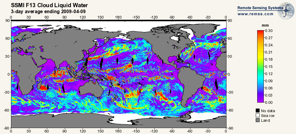
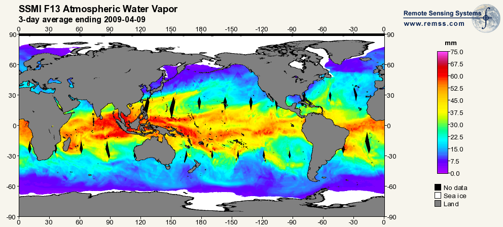
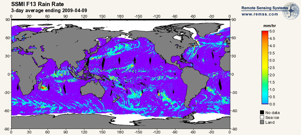
Federal
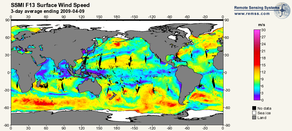
RSS SSM/I OCEAN PRODUCT GRIDS 3-DAY AVERAGE FROM DMSP F13 NETCDF V7 recent views
National Aeronautics and Space Administration —
The RSS SSM/I Ocean Product Grids 3-Day Average from DMSP F13 netCDF dataset is part of the collection of Special Sensor Microwave/Imager (SSM/I) and Special Sensor... -
Federal
NPP Tropical Forest: Manaus, Brazil, 1963-1990 , R1 recent views
National Aeronautics and Space Administration —
This data set includes six ASCII files (.txt format). Five files contain productivity values for several types of tropical Amazon rainforest near Manaus, Brazil... -
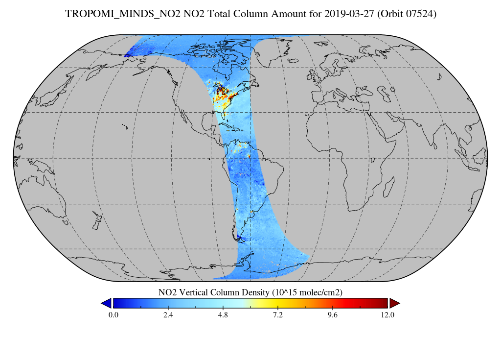
Federal
TROPOMI/S5P NO2 Tropospheric, Stratospheric and Total Columns MINDS 1-Orbit L2 Swath 5.5 km x 3.5 km V1.1 (TROPOMI_MINDS_NO2) at GES DISC recent views
National Aeronautics and Space Administration —
As part of the NASA's Making Earth System Data Records for Use in Research Environments (MEaSUREs) program, this project entitled “Multi-Decadal Nitrogen Dioxide and... -
Federal
TOVS GLA MONTHLY GRIDS from TIROSN V01 (TOVSAMTN) at GES DISC recent views
National Aeronautics and Space Administration —
This dataset (TOVSAMTN) contains the TIROS Operational Vertical Sounder (TOVS) level 3 geophysical parameters derived using data from TIROSN and the physical... -
Federal
Aqua/AIRS L2 Near Real Time (NRT) Cloud-Cleared Infrared Radiances (AIRS-only) V7.0 at GES DISC recent views
National Aeronautics and Space Administration —
The Atmospheric Infrared Sounder (AIRS) Level 2 Near Real Time (NRT) Cloud-Cleared Infrared Radiances (AIRS-only) product (AIRS2CCF_NRT_7.0) differs from the routine... -
Federal
NOAA/WDS Paleoclimatology - Yao fire data from Pangu, Daxing'an Mountain, Heilongjiang, northeast China - IMPD CNPG-001 recent views
National Oceanic and Atmospheric Administration, Department of Commerce —
This archived Paleoclimatology Study is available from the NOAA National Centers for Environmental Information (NCEI), under the World Data Service (WDS) for... -
Federal
NOAA/WDS Paleoclimatology - Brown fire data from Archuleta Mesa Plot A2 - IMPD USACH005 recent views
National Oceanic and Atmospheric Administration, Department of Commerce —
This archived Paleoclimatology Study is available from the NOAA National Centers for Environmental Information (NCEI), under the World Data Service (WDS) for... -
Federal
SatCORPS CERES GEO Edition 4 GOES-14 Southern Hemisphere Version 1.0 recent views
National Aeronautics and Space Administration —
CER_GEO_Ed4_GOE14_SH_V01 is the Satellite Cloud and Radiation Property retrieval System (SatCORPS) Clouds and the Earth's Radiant Energy System (CERES) Geostationary...

Official websites use .gov
A
.gov website belongs to an official government
organization in the United States.
Secure .gov websites use HTTPS
A
lock (
) or https:// means you’ve safely connected to
the .gov website. Share sensitive information only on official,
secure websites.