
-
Federal
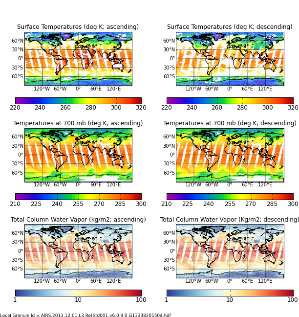
AIRS/Aqua L3 8-day Standard Physical Retrieval (AIRS-only) 1 degree X 1 degree V006 (AIRS3ST8) at GES DISC
National Aeronautics and Space Administration —
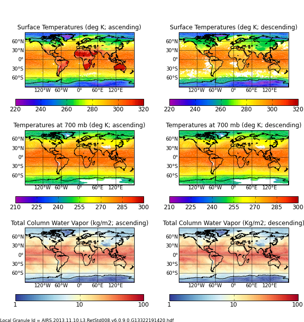
The Atmospheric Infrared Sounder (AIRS) is a grating spectrometer (R = 1200) aboard the second Earth Observing System (EOS) polar-orbiting platform, EOS Aqua. In... -
Federal
AIRS/Aqua L3 Monthly Standard Physical Retrieval (AIRS+AMSU) 1 degree x 1 degree V006 (AIRX3STM) at GES DISC
National Aeronautics and Space Administration —
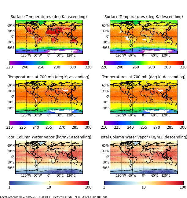
The Atmospheric Infrared Sounder (AIRS) is a grating spectrometer (R = 1200) aboard the second Earth Observing System (EOS) polar-orbiting platform, EOS Aqua. In... -
Federal
GLDAS Noah Land Surface Model L4 monthly 1.0 x 1.0 degree V2.0 (GLDAS_NOAH10_M) at GES DISC
National Aeronautics and Space Administration —
NASA Global Land Data Assimilation System Version 2 (GLDAS-2) has three components: GLDAS-2.0, GLDAS-2.1, and GLDAS-2.2. GLDAS-2.0 is forced entirely with the... -
Federal
BOREAS/SRC AMS Suite A Surface Meteorological and Radiation Data: 1996
National Aeronautics and Space Administration —
Contains the data collected in 1996 by the AMS suite A instrument set operated by SRC and provided to BORIS. -
Federal
Aqua/AIRS L3 Monthly Support Product (AIRS+AMSU) 1 degree x 1 degree V7.0 at GES DISC
National Aeronautics and Space Administration —
The Atmospheric Infrared Sounder (AIRS) is a grating spectrometer (R = 1200) aboard the second Earth Observing System (EOS) polar-orbiting platform, EOS Aqua. In... -
Federal
Sounder SIPS: Suomi NPP CrIMSS Level 3 Specific Quality Control Gridded Daily SiFSAP V2 (SNDRSNIML3SDSFSP) at GES DISC
National Aeronautics and Space Administration —
The SIFSAP (Single Field-of-View Sounder Atmospheric Products) algorithm provides retrieval for each sounder Field of View (FOV), therefore, it has 3-times higher... -
Federal
NLDAS Noah Land Surface Model L4 Monthly 0.125 x 0.125 degree V2.0 (NLDAS_NOAH0125_M) at GES DISC
National Aeronautics and Space Administration —
This data set contains fifty-two fields simulated from the Noah land-surface model (LSM) for Phase 2 of the North American Land Data Assimilation System (NLDAS-2).... -
Federal
Aqua/AIRS L2 Near Real Time (NRT) Support Retrieval (AIRS-only) V7.0 at GES DISC
National Aeronautics and Space Administration —
The Atmospheric Infrared Sounder (AIRS) Level 2 Near Real Time (NRT) Support Retrieval (AIRS-only) product (AIRS2SUP_NRT_7.0) differs from the routine product... -
Federal
Sounder SIPS: JPSS-1 CrIS Level 3 Comprehensive Quality Control Gridded Monthly CLIMCAPS V2 (SNDRJ1IML3CMCCP) at GES DISC
National Aeronautics and Space Administration —
WARNING: To users of the derived product “co_mmr_midtrop” (carbon monoxide mass mixing ratio to dry air [kg/kg] at ~500 hPa). This variable has a significant bias due... -
Federal
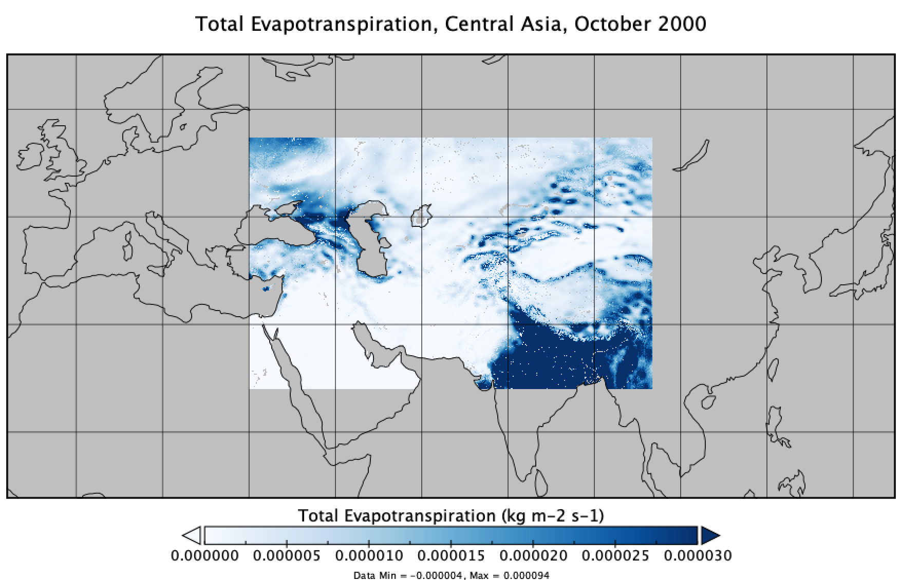
FLDAS Noah Land Surface Model L4 Central Asia Daily 0.01 x 0.01 degree V001 (FLDAS_NOAH001_G_CA_D) at GES DISC
National Aeronautics and Space Administration —
This dataset contains a series of land surface parameters simulated from the Noah 3.6.1 model in the Famine Early Warning Systems Network (FEWS NET) Land Data... -
Federal
Aqua/AIRS L3 Daily Standard Physical Retrieval (AIRS-only) 1 degree x 1 degree V7.0 at GES DISC
National Aeronautics and Space Administration —
The Atmospheric Infrared Sounder (AIRS) is a grating spectrometer (R = 1200) aboard the second Earth Observing System (EOS) polar-orbiting platform, EOS Aqua. The... -
Federal
Sounder SIPS: JPSS-1 ATMS Level 2 RAMSES2 Standard: Atmosphere, precipitation and surface geophysical state V3 (SNDRJ1ML2RMS) at GES DISC
National Aeronautics and Space Administration —
This level 2 product is generated by the RAMSES (Retrieval Algorithm for Microwave Sounders in Earth Science II algorithm.The RAMSES II algorithm is a microwave only... -
Federal
Sounder SIPS: Suomi NPP ATMS Level 2 RAMSES2 Standard: Atmosphere, precipitation and surface geophysical state, V3 (SNDRSNML2RMS ) at GES DISC
National Aeronautics and Space Administration —
This level 2 product is generated by the RAMSES (Retrieval Algorithm for Microwave Sounders in Earth Science) II algorithm.The RAMSES II algorithm is a microwave only... -
Federal
Aqua/AIRS L3 Daily Standard Physical Retrieval (AIRS+AMSU) 1 degree x 1 degree V7.0 at GES DISC
National Aeronautics and Space Administration —
The Atmospheric Infrared Sounder (AIRS) is a grating spectrometer (R = 1200) aboard the second Earth Observing System (EOS) polar-orbiting platform, EOS Aqua. In... -
Federal
AIRS/Aqua L2 Standard Physical Retrieval (AIRS+AMSU+HSB) V006 (AIRH2RET) at GES DISC
National Aeronautics and Space Administration —
The Atmospheric Infrared Sounder (AIRS) is a grating spectrometer (R = 1200) aboard the second Earth Observing System (EOS) polar-orbiting platform, EOS Aqua. In... -
Federal
GLDAS Noah Land Surface Model L4 3 hourly 1.0 x 1.0 degree V2.1 (GLDAS_NOAH10_3H) at GES DISC
National Aeronautics and Space Administration —
NASA Global Land Data Assimilation System Version 2 (GLDAS-2) has three components: GLDAS-2.0, GLDAS-2.1, and GLDAS-2.2. GLDAS-2.0 is forced entirely with the... -
Federal
TOVS GLA 5 DAY GRIDS from NOAA-10 V01 (TOVSA5NG) at GES DISC
National Aeronautics and Space Administration —
This dataset (TOVSA5NG) contains the TIROS Operational Vertical Sounder (TOVS) level 3 geophysical parameters derived using data from NOAA-10 and the physical... -
Federal
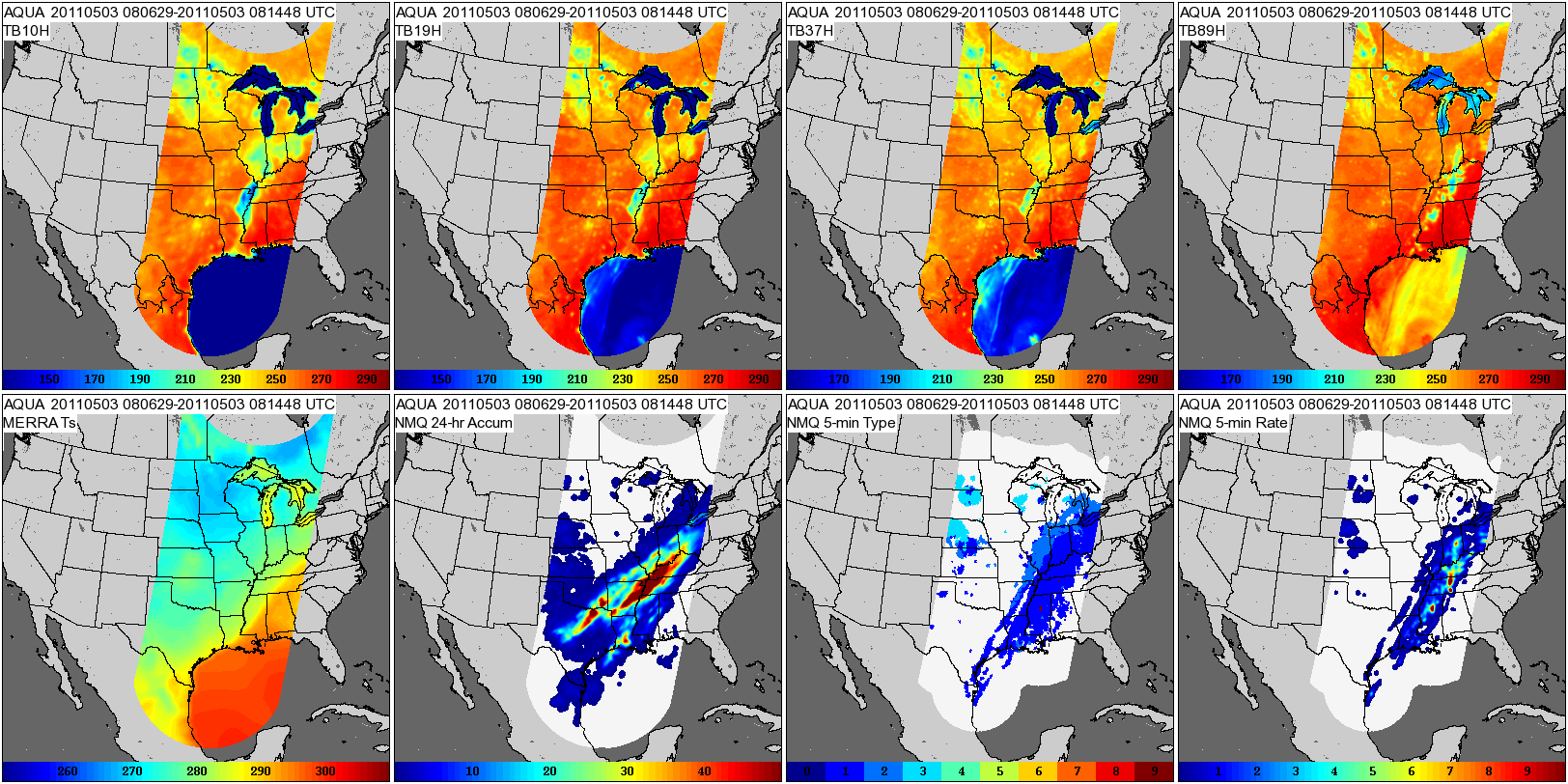
GPM GROUND VALIDATION COMPOSITE SATELLITE OVERPASSES MC3E V1
National Aeronautics and Space Administration —
The GPM Ground Validation Composite Satellite Overpasses MC3E dataset provides satellite overpasses from the AQUA satellite during the Midlatitude Continental... -
Federal
AIRS/Aqua L3 Daily Support Daily Product (AIRS+AMSU+HSB) 1 degree x 1 degree V006 (AIRH3SPD) at GES DISC
National Aeronautics and Space Administration —
The Atmospheric Infrared Sounder (AIRS) is a grating spectrometer (R = 1200) aboard the second Earth Observing System (EOS) polar-orbiting platform, EOS Aqua. In... -
Federal
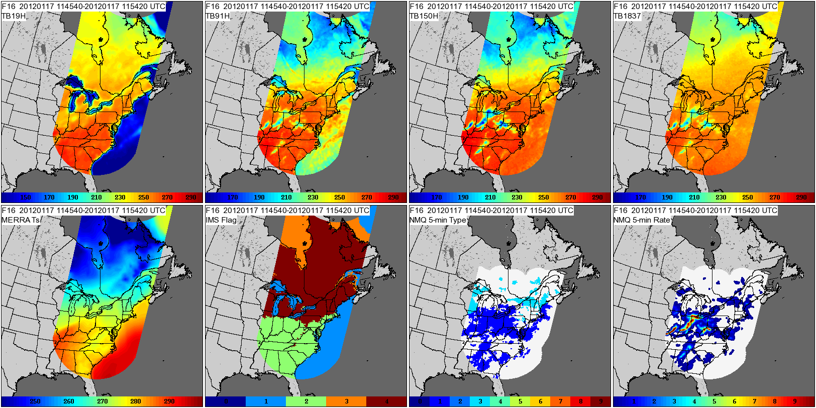
GPM GROUND VALIDATION COMPOSITE SATELLITE OVERPASSES GCPEX V1
National Aeronautics and Space Administration —
The GPM Ground Validation Composite Satellite Overpasses GCPEx dataset provides satellite overpasses from the Special Sensor Microwave Imager/Sounder (SSMIS)...

Official websites use .gov
A
.gov website belongs to an official government
organization in the United States.
Secure .gov websites use HTTPS
A
lock (
) or https:// means you’ve safely connected to
the .gov website. Share sensitive information only on official,
secure websites.