

FLDAS Noah Land Surface Model L4 Central Asia Daily 0.01 x 0.01 degree V001 (FLDAS_NOAH001_G_CA_D) at GES DISC
Access & Use Information
Downloads & Resources
-
Google Scholar search resultsHTML
Search results for publications that cite this dataset by its DOI.
-
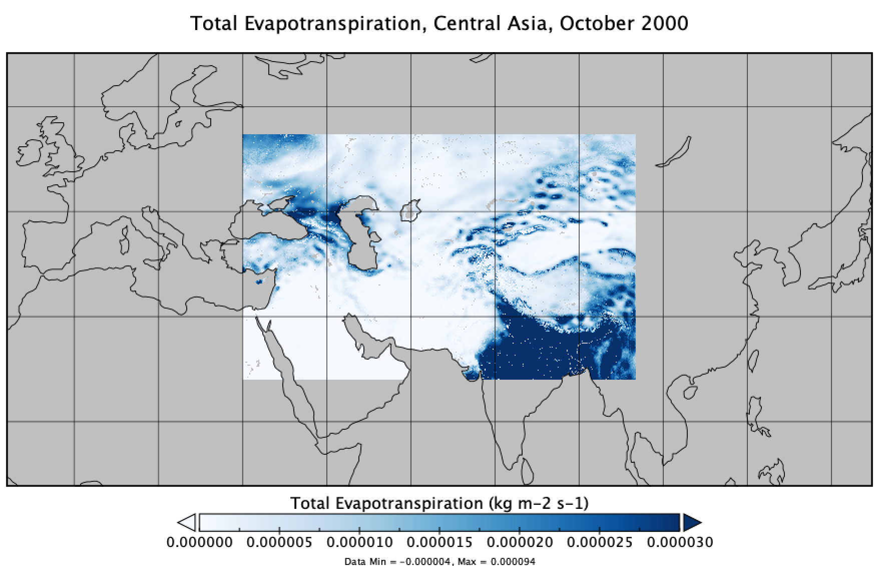
Get a related visualizationPNG
FLDAS Noah Land Surface Model L4 Central Asia Daily 0.01 x 0.01 degree, Total...
-
This dataset's landing pageHTML
Access the dataset landing page from the GES DISC website.
-
Download this dataset through a directory mapHTML
Access the data via HTTPS.
-
Download this dataset through Earthdata SearchHTML
Use the Earthdata Search to find and retrieve data sets across multiple data...
-
Get a related visualization through GIOVANNIHTML
The GES-DISC Interactive Online Visualization ANd aNalysis Interface...
-
Use OPeNDAP to access the dataset's dataHTML
Access the data via the OPeNDAP protocol.
-
View this dataset's read me documentPDF
README Document
-
The dataset's project home pageHTML
FLDAS Project Website
-
View this dataset's how-to documentationHTML
How to read and plot the data.
-
View documentation related to this datasetHTML
GES DISC Hydrology Documentation
-
View this dataset's product usageHTML
The MOD44W MODIS Water Mask is the standard land/sea mask for FLDAS, and is...
-
Landing PageLanding Page
References
| https://doi.org/10.1038/sdata.2017.12 |
| https://doi.org/10.3390/w11101968 |
| https://doi.org/10.1016/j.envsoft.2005.07.004 |
| https://doi.org/10.1175/JHM-D-12-046.1 |
Dates
| Metadata Created Date | December 1, 2022 |
|---|---|
| Metadata Updated Date | December 6, 2023 |
Metadata Source
- Data.json Data.json Metadata
Harvested from NASA Data.json
Graphic Preview
Additional Metadata
| Resource Type | Dataset |
|---|---|
| Metadata Created Date | December 1, 2022 |
| Metadata Updated Date | December 6, 2023 |
| Publisher | NASA/GSFC/SED/ESD/GCDC/GESDISC |
| Maintainer | |
| Identifier | C2020764153-GES_DISC |
| Data First Published | 2021-03-02 |
| Language | en-US |
| Data Last Modified | 2021-03-02 |
| Category | FLDAS, geospatial |
| Public Access Level | public |
| Bureau Code | 026:00 |
| Metadata Context | https://project-open-data.cio.gov/v1.1/schema/catalog.jsonld |
| Metadata Catalog ID | https://data.nasa.gov/data.json |
| Schema Version | https://project-open-data.cio.gov/v1.1/schema |
| Catalog Describedby | https://project-open-data.cio.gov/v1.1/schema/catalog.json |
| Citation | Jossy Jacob, Kimberly Slinski (NASA/GSFC/HSL). 2021-03-02. FLDAS_NOAH001_G_CA_D. Version 001. FLDAS Noah Land Surface Model L4 Central Asia Daily 0.01 x 0.01 degree. Greenbelt, MD, USA. Archived by National Aeronautics and Space Administration, U.S. Government, Goddard Earth Sciences Data and Information Services Center (GES DISC). https://doi.org/10.5067/VQ4CD3Y9YC0R. https://disc.gsfc.nasa.gov/datacollection/FLDAS_NOAH001_G_CA_D_001.html. Digital Science Data. |
| Creator | Jossy Jacob, Kimberly Slinski (NASA/GSFC/HSL) |
| Data Presentation Form | Digital Science Data |
| Graphic Preview Description | The GES-DISC Interactive Online Visualization ANd aNalysis Interface (Giovanni) is a web-based tool that allows users to interactively visualize and analyze data. |
| Graphic Preview File | https://giovanni.gsfc.nasa.gov/giovanni/#dataKeyword=FLDAS_NOAH001_G_CA_D |
| Harvest Object Id | 7904bb98-1676-45cd-af88-c2b9bfd051c1 |
| Harvest Source Id | 58f92550-7a01-4f00-b1b2-8dc953bd598f |
| Harvest Source Title | NASA Data.json |
| Homepage URL | https://doi.org/10.5067/VQ4CD3Y9YC0R |
| Metadata Type | geospatial |
| Old Spatial | 30.0 21.0 100.0 56.0 |
| Program Code | 026:001 |
| Related Documents | https://doi.org/10.1038/sdata.2017.12, https://doi.org/10.3390/w11101968, https://doi.org/10.1016/j.envsoft.2005.07.004, https://doi.org/10.1175/JHM-D-12-046.1 |
| Release Place | Greenbelt, MD, USA |
| Series Name | FLDAS_NOAH001_G_CA_D |
| Source Datajson Identifier | True |
| Source Hash | 2fe63c0f1ae95a221de1b805b3c43e13c9a8099c7b987bbcd1b601ad2931f9a2 |
| Source Schema Version | 1.1 |
| Spatial | |
| Temporal | 2000-10-01T00:00:00Z/2022-01-17T00:00:00Z |
Didn't find what you're looking for? Suggest a dataset here.