
-
Federal
FIREX-AQ NOAA-CHEM Twin Otter In Situ Trace Gas Data
National Aeronautics and Space Administration —
FIREXAQ_TraceGas_AircraftInSitu_N48_Data are in situ trace gas data collected onboard the NOAA-CHEM Twin Otter during FIREX-AQ. This product features data collected... -
Federal
FIREX-AQ Merge Data Files
National Aeronautics and Space Administration —
FIREXAQ_Merge_Data are pre-generated merge data files collected during FIREX-AQ. These files contain merged data products collected onboard the DC-8 aircraft.... -
Federal
FIREX-AQ NOAA-CHEM Twin Otter Photolysis Rate (j value) Data
National Aeronautics and Space Administration —
FIREXAQ_jValue_AircraftInSitu_N48_Data are in situ photolysis rate (j value) data collected onboard the NOAA-CHEM Twin Otter aircraft during FIREX-AQ. Data collection... -
Federal
FIREX-AQ Satellite And Related Ancillary Data
National Aeronautics and Space Administration —
FIREXAQ_Satellite_Data are supplementary satellite and related ancillary data collected during FIREX-AQ. This product includes data from the VIIRS, GOES-16, and... -
Federal
FIREX-AQ In-Situ Ground Data
National Aeronautics and Space Administration —
FIREXAQ_Ground_InSitu_Data are in-situ ground measurements collected during FIREX-AQ. Data collection for this product is complete.Completed during summer 2019,... -
Federal
EMIT L1B At-Sensor Calibrated Radiance and Geolocation Data 60 m V001
National Aeronautics and Space Administration —
The Earth Surface Mineral Dust Source Investigation (EMIT) instrument measures surface mineralogy, targeting the Earth’s arid dust source regions. EMIT is installed... -
Federal
EMIT L2B Estimated Methane Plume Complexes 60 m V001
National Aeronautics and Space Administration —
The Earth Surface Mineral Dust Source Investigation (EMIT) instrument measures surface mineralogy, targeting the Earth’s arid dust source regions. EMIT is installed... -
Federal
EMIT L1B Corrected Spacecraft Attitude and Ephemeris V001
National Aeronautics and Space Administration —
The Earth Surface Mineral Dust Source Investigation (EMIT) instrument measures surface mineralogy, targeting the Earth’s arid dust source regions. EMIT is installed... -
Federal
Spitzer Wide-area InfraRed Extragalactic Survey XMM-LSS MIPS 160 micron Catalog
National Aeronautics and Space Administration —
The Spitzer Wide-area InfraRed Extragalactic survey (SWIRE), the largest Spitzer Legacy program, is a wide-area, imaging survey to trace the evolution of dusty, star-... -
Federal
Sloan Digital Sky Survey DR7 White Dwarf Catalog
National Aeronautics and Space Administration —
This table contains a new catalog of spectroscopically confirmed white dwarf stars from the Sloan Digital Sky Survey (SDSS) Data Release 7 (DR7) spectroscopic... -
Federal
C2D Candidate YSO CLOUDS Catalog
National Aeronautics and Space Administration —
The Cores to Disks (C2D) Spitzer Legacy Program used all three Spitzer instruments (IRAC, MIPS, and IRS) to observe sources that span the evolutionary sequence from... -
Federal
HERITAGE SMC PACS 160 micron Catalog
National Aeronautics and Space Administration —
The HERschel Inventory of The Agents of Galaxy Evolution (HERITAGE) open time key program mapped the Large Magellanic Cloud (LMC) and Small Magellanic Cloud (SMC) at... -
Federal
C2D Full CLOUDS Catalog
National Aeronautics and Space Administration —
The Cores to Disks (C2D) Spitzer Legacy Program used all three Spitzer instruments (IRAC, MIPS, and IRS) to observe sources that span the evolutionary sequence from... -
Federal
Planck PCCS2E 100GHz Catalog
National Aeronautics and Space Administration —
The second Planck Catalogue of Compact Sources (PCCS2) is a set of single-frequency source catalogues extracted from the Planck full-mission maps in intensity and... -
Federal
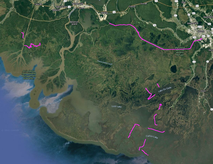
Delta-X: In-situ Water Surface Elevation, MRD, Louisiana, USA, 2021
National Aeronautics and Space Administration —
This dataset contains in situ water level measurements collected at 49 different locations across the Atchafalaya and Terrebonne basins in the Mississippi River Delta... -
Federal
9C Continued 15-GHz Ryle Telescope Survey of VSA Fields Source Catalog
National Aeronautics and Space Administration —
The 9C (9th Cambridge) survey of radio sources with the Ryle Telescope at 15.2 GHz was set up to survey the fields of the cosmic microwave background telescope, the... -
Federal
Murchison Widefield Array 32-T Low-Frequency Source Catalog
National Aeronautics and Space Administration —
The Murchison Widefield Array (MWA) is a new low-frequency, wide-field-of-view radio interferometer under development at the Murchison Radio-astronomy Observatory in... -
Federal
Chandra Deep Field North 2-Megasecond Improved Point Source Catalog
National Aeronautics and Space Administration —
This table contains the improved point-source catalog for the 2-Ms Chandra Deep Field-North (CDF-N) Survey, implementing a number of recent improvements in Chandra... -
Federal
Rosette Molecular Cloud Chandra X-Ray Point Source Catalog
National Aeronautics and Space Administration —
The authors of this study have explored the young stellar populations in the Rosette Molecular Cloud (RMC) region with high spatial resolution X-ray images from the... -
Federal
Early-Type Galaxies Chandra X-Ray Point Source Catalog
National Aeronautics and Space Administration —
This table contains the results of a Chandra survey of low-mass X-ray binaries (LMXBs) in 24 early-type galaxies. Correcting for detection incompleteness, the X-ray...

Official websites use .gov
A
.gov website belongs to an official government
organization in the United States.
Secure .gov websites use HTTPS
A
lock (
) or https:// means you’ve safely connected to
the .gov website. Share sensitive information only on official,
secure websites.