
-
Federal
NGC 2244/Rosette Nebula Chandra X-Ray Point Source Catalog
National Aeronautics and Space Administration —
This table contains the point source catalog based on the first high spatial resolution X-ray study of NGC 2244, the 2 Myr old stellar cluster in the Rosette Nebula,... -
Federal
First ISCCP Regional Experiment (FIRE) Cirrus 1 Surface Radiation Budget (SRB) Longwave Radiation Data
National Aeronautics and Space Administration —
These data contain down-welled global longwave hemispherical radiation taken during the Wisconsin FIRE/SRB experiment. The data set consists of measurements taken... -
Federal
EUtrophic, MEsotrophic and oLIgotrophic (EUMELI) regimes program
National Aeronautics and Space Administration —
Measurements from the EUMELI program, a component of FRANCE-JGOFS (Joint Global Ocean Flux Study), to study ocean fluxes in eutrophic, mesotrophic and oligotrophic... -
Federal
Global Space-based Stratospheric Aerosol Climatology Version 2.21
National Aeronautics and Space Administration —
The Global Space-based Stratospheric Aerosol Climatology, or GloSSAC, is a 44-year climatology of stratospheric aerosol properties focused on extinction coefficient... -
Federal
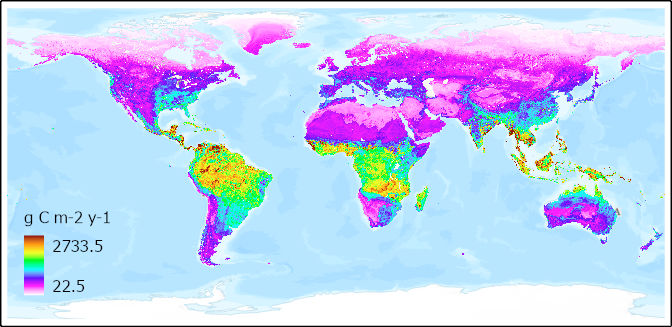
Global Gridded 1-km Soil and Soil Heterotrophic Respiration Derived from SRDB v5
National Aeronautics and Space Administration —
This dataset provides global gridded estimates of annual soil respiration (Rs) and soil heterotrophic respiration (Rh) and associated uncertainties at 1 km... -
Federal
2dF QSO Redshift (2QZ) Survey
National Aeronautics and Space Administration —
The final catalog of the 2dF QSO Redshift Survey (2QZ) is based on Anglo-Australian Telescope 2dF spectroscopic observations of 44,576 color-selected (u, bJ, r)... -
Federal
GOES-R PLT Surface Radiance Ivanpah V1
National Aeronautics and Space Administration —
The GOES-R PLT Field Campaign Ivanpah dataset consists of surface reflectance and total optical depth data measured at Ivanpah Playa, Nevada during the GOES-R Post... -
Federal
Global Navigation Satellite System (GNSS) IGS Ionosphere Vertical Total Electron Content (VTEC) Analysis Center (AC) Rapid Product from NASA CDDIS
National Aeronautics and Space Administration —
This derived product set consists of Global Navigation Satellite System Rapid Ionosphere Vertical Total Electron Content (VTEC) product (daily files) from the NASA... -
Federal
GHRSST Level 3U NOAA ACSPO SST v2.80 from VIIRS on NOAA-21 Satellite
National Aeronautics and Space Administration —
The N21-VIIRS-L3U-ACSPO-v2.80 dataset produced by the NOAA ACSPO system derives the Subskin Sea Surface Temperature (SST) from the Visible Infrared Imaging Radiometer... -
Federal
Uhuru Fourth (4U) Catalog
National Aeronautics and Space Administration —
The Fourth Uhuru (4U) Catalog lists 339 X-ray sources that were observed with the Uhuru (SAS A) X-ray observatory. It contains positional information in the form of... -
Federal
COSMOS Photometric Redshift Catalog
National Aeronautics and Space Administration —
COSMOS is an astronomical survey designed to probe the formation and evolution of galaxies as a function of cosmic time (redshift) and large scale structural... -
Federal
Fermi LAT Second Catalog of Gamma-Ray Pulsars (2PC)
National Aeronautics and Space Administration —
This catalog summarizes 0.1 GeV gamma-ray pulsar detections using data acquired by the Large Area Telescope (LAT) on the Fermi satellite. These pulsars are neutron... -
Federal
GHRSST NOAA/STAR Metop-B AVHRR FRAC ACSPO v2.80 1km L2P Dataset (GDS v2)
National Aeronautics and Space Administration —
The MetOp First Generation (FG) is a European multi-satellite program jointly established by ESA and EUMETSAT, comprising three satellites, MetOp-A, -B and -C. The... -
Federal
Sloan Digital Sky Survey DR7 White Dwarf Catalog
National Aeronautics and Space Administration —
This table contains a new catalog of spectroscopically confirmed white dwarf stars from the Sloan Digital Sky Survey (SDSS) Data Release 7 (DR7) spectroscopic... -
Federal
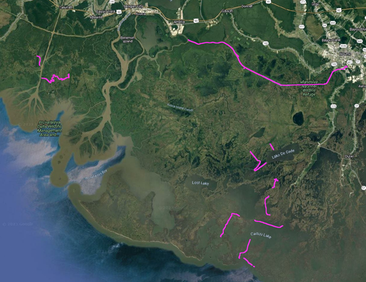
Delta-X: In-situ Water Surface Elevation, MRD, Louisiana, USA, 2021
National Aeronautics and Space Administration —
This dataset contains in situ water level measurements collected at 49 different locations across the Atchafalaya and Terrebonne basins in the Mississippi River Delta... -
Federal
Rosette Molecular Cloud Chandra X-Ray Point Source Catalog
National Aeronautics and Space Administration —
The authors of this study have explored the young stellar populations in the Rosette Molecular Cloud (RMC) region with high spatial resolution X-ray images from the... -
Federal
Orion Flanking Fields Chandra X-Ray Point Source Catalog
National Aeronautics and Space Administration —
This table contains the results of Chandra observations of two flanking fields (FFs) in Orion outside the Orion Nebula Cluster (ONC), in the form of a catalog of 417... -
Federal
ROSAT Hard-Spectrum X-Ray Source Catalog
National Aeronautics and Space Administration —
This table contains a catalog of 147 serendipitous X-ray sources selected to have hard spectra (spectral indices Alpha < 0.5) from a survey of 188 ROSAT fields.... -
Federal
SAGE IRAC Single Frame + Mosaic Photometry Archive
National Aeronautics and Space Administration —
The Spitzer Space Telescope Survey of the Large Magellanic Cloud Legacy Project Surveying the Agents of a Galaxy's Evolution (SAGE) traces the life cycle of... -
Federal
Delta-X: Real-Time Kinematic Elevation Measurements for Coastal Wetlands, LA, 2021
National Aeronautics and Space Administration —
This dataset provides real-time kinematic (RTK) GPS elevation measurements, along with horizontal and vertical precision errors, obtained along transects near...

Official websites use .gov
A
.gov website belongs to an official government
organization in the United States.
Secure .gov websites use HTTPS
A
lock (
) or https:// means you’ve safely connected to
the .gov website. Share sensitive information only on official,
secure websites.