
-
Federal
Bathymetry (Alaska and surrounding waters)
National Oceanic and Atmospheric Administration, Department of Commerce —
A Raster having 20 m resolution with decimal values was assembled from 18.6 billion bathymetric soundings that were obtained from the National Center for... -
Federal
2024 IN DNR Lidar DEM: Indiana Coastline
National Oceanic and Atmospheric Administration, Department of Commerce —
Original Product: These are Digital Elevation Model (DEM) data as part of the required deliverables for the lidar project. Class 2 (Ground) lidar points in... -
Federal
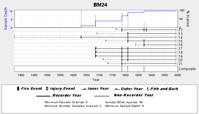
NOAA/WDS Paleoclimatology - Veblen fire data from BM24 - IMPD USBM-024
National Oceanic and Atmospheric Administration, Department of Commerce —
This archived Paleoclimatology Study is available from the NOAA National Centers for Environmental Information (NCEI), under the World Data Service (WDS) for... -
Federal
Trajectory profile data from glider ru34, including pH, Total Alkalinity, and Aragonite Saturation State, deployed by Rutgers, the State University of New Jersey in the Mid-Atlantic Bight from 2023-09-20 to 2023-10-19 (NCEI Accession 0306334)
National Oceanic and Atmospheric Administration, Department of Commerce —
This dataset contains the trajectory profile data from glider ru34 from one seasonal deployment (2023-09-20 to 2023-10-19). This deployment (glider trajectory... -
Federal
NCCOS Mapping: Merged Bathymetry Data in the Channel Islands National Marine Sanctuary for Benthic Habitat Mapping from 1998 to 2022 (NCEI Accession 0304093)
National Oceanic and Atmospheric Administration, Department of Commerce —
We created merged bathymetry surfaces segmented in GeoTIFF format by resolution and depth within the Channel Islands National Marine Sanctuary (CINMS) from more than... -
Federal
Coastal Bend Texas Benthic Habitat Mapping Patchy Shapefile Map - San Antonio Bay and Espiritu Santo Bay
National Oceanic and Atmospheric Administration, Department of Commerce —
The NOAA Office for Coastal Management (OCM) requested the creation of benthic habitat data along the southern Texas coast to support the Texas Seagrass Monitoring... -
Federal
NOAA/WDS Paleoclimatology - Brown fire data from Cherry Canyon - IMPD USCHR001
National Oceanic and Atmospheric Administration, Department of Commerce —
This archived Paleoclimatology Study is available from the NOAA National Centers for Environmental Information (NCEI), under the World Data Service (WDS) for... -
Federal
NOAA/WDS Paleoclimatology - Brown fire data from O'Neill Pass - IMPD USONP001
National Oceanic and Atmospheric Administration, Department of Commerce —
This archived Paleoclimatology Study is available from the NOAA National Centers for Environmental Information (NCEI), under the World Data Service (WDS) for... -
Federal
NOAA/WDS Paleoclimatology - Bigio fire data from Klyuchi village, Siberia - IMPD RUKLU001
National Oceanic and Atmospheric Administration, Department of Commerce —
This archived Paleoclimatology Study is available from the NOAA National Centers for Environmental Information (NCEI), under the World Data Service (WDS) for... -
Federal
NOAA/WDS Paleoclimatology - Everett fire data from Frosty Aspect Polygon 5 - IMPD USFRS005
National Oceanic and Atmospheric Administration, Department of Commerce —
This archived Paleoclimatology Study is available from the NOAA National Centers for Environmental Information (NCEI), under the World Data Service (WDS) for... -
Federal
NOAA/WDS Paleoclimatology - Heyerdahl fire data from Cove Mountain - IMPD USCOV001
National Oceanic and Atmospheric Administration, Department of Commerce —
This archived Paleoclimatology Study is available from the NOAA National Centers for Environmental Information (NCEI), under the World Data Service (WDS) for... -
Federal
NOAA/WDS Paleoclimatology - Heyerdahl fire data from Abajo Mountain - IMPD USABM001
National Oceanic and Atmospheric Administration, Department of Commerce —
This archived Paleoclimatology Study is available from the NOAA National Centers for Environmental Information (NCEI), under the World Data Service (WDS) for... -
Federal
NOAA/WDS Paleoclimatology - Margolis fire data from Los Griegos Plot 1, northern New Mexico - IMPD USLGR001
National Oceanic and Atmospheric Administration, Department of Commerce —
This archived Paleoclimatology Study is available from the NOAA National Centers for Environmental Information (NCEI), under the World Data Service (WDS) for... -
Federal
NOAA/WDS Paleoclimatology - Brown fire data from Manitou Demo Plot - IMPD USMDP001
National Oceanic and Atmospheric Administration, Department of Commerce —
This archived Paleoclimatology Study is available from the NOAA National Centers for Environmental Information (NCEI), under the World Data Service (WDS) for... -
Federal
NOAA/WDS Paleoclimatology - Brown fire data from Archuleta Mesa Plot B2 - IMPD USACH014
National Oceanic and Atmospheric Administration, Department of Commerce —
This archived Paleoclimatology Study is available from the NOAA National Centers for Environmental Information (NCEI), under the World Data Service (WDS) for... -
Federal
Fall 2010 SAV Classification
National Oceanic and Atmospheric Administration, Department of Commerce —
The sub-aquatic vegitation map for was produced for the SAV Technical Working Group under a cooperative workplan with BP. The SAV map was derived from 0.3 meter... -
Federal
NOAA ESRI Geotiff- 1m Bathymetry of St. Croix (Buck Island), US Virgin Islands, 2004, UTM 20 WGS84
National Oceanic and Atmospheric Administration, Department of Commerce —
This dataset contains an ESRI Geotiff with 1 meter cell size representing the bathymetry of the north shore of Buck Island St. Croix, US Virgin Islands.NOAA's... -
Federal
Using Advanced Mapping to Measure Changes in Mangrove and Seagrass Habitat over Time - NERRS/NSC(NERRS Science Collaborative)
National Oceanic and Atmospheric Administration, Department of Commerce —
This project evaluated ecosystem damage and recovery by developing a time series of habitat maps for the Rookery Bay National Estuarine Research Reserve. Habitat maps... -
Federal
Limits of Resilience: Uncertain Recovery in Mangrove Ecosystems Following Repeated Hurricane Disturbance - NERRS/NSC(NERRS Science Collaborative)
National Oceanic and Atmospheric Administration, Department of Commerce —
Building on the momentum of an earlier collaborative project, this team and their users reunited to assess how mangrove recovery and resilience is impacted by... -
Federal
Mangrove Coast Collaborative / Colaboracion en Mangles Costeros: Understanding Links between Degradation, Recovery, and Community Benefits - NERRS/NSC(NERRS Science Collaborative)
National Oceanic and Atmospheric Administration, Department of Commerce —
Shared impacts and needs following Hurricanes Irma and Maria brought together two reserves to assess mangrove recovery, leading to more holistic decision-making...

Official websites use .gov
A
.gov website belongs to an official government
organization in the United States.
Secure .gov websites use HTTPS
A
lock (
) or https:// means you’ve safely connected to
the .gov website. Share sensitive information only on official,
secure websites.