
-
Federal
H13384: NOS Hydrographic Survey , 2021-03-10
National Oceanic and Atmospheric Administration, Department of Commerce —
The National Oceanic and Atmospheric Administration (NOAA) has the statutory mandate to collect hydrographic data in support of nautical chart compilation for safe... -
Federal
H13216: NOS Hydrographic Survey , 2019-09-28
National Oceanic and Atmospheric Administration, Department of Commerce —
The National Oceanic and Atmospheric Administration (NOAA) has the statutory mandate to collect hydrographic data in support of nautical chart compilation for safe... -
Federal
H13682: NOS Hydrographic Survey , 2022-09-21
National Oceanic and Atmospheric Administration, Department of Commerce —
The National Oceanic and Atmospheric Administration (NOAA) has the statutory mandate to collect hydrographic data in support of nautical chart compilation for safe... -
Federal
North Carolina Seagrass Submersed Rooted Vasculars 1990 Substrate
National Oceanic and Atmospheric Administration, Department of Commerce —
A GIS data set of polygon data interpreted from aerial photography taken by NOAA/NOS Photogrammetry Branch depicting areas of Aquatic Beds of Rooted Vascular Plants... -
Federal
H13214: NOS Hydrographic Survey , 2019-09-25
National Oceanic and Atmospheric Administration, Department of Commerce —
The National Oceanic and Atmospheric Administration (NOAA) has the statutory mandate to collect hydrographic data in support of nautical chart compilation for safe... -
Federal
Caernarvon 2001
National Oceanic and Atmospheric Administration, Department of Commerce —
Sampled marshes and ponds along two transects within the intermediate and brackish marsh zones of Breton Sound, Louisiana, from May 7-11, 2001. Sampling followed... -
Federal
Spring Bottom Trawl Survey
National Oceanic and Atmospheric Administration, Department of Commerce —
The standardized NEFSC Spring Bottom Trawl Survey was initiated in 1968 and covered an area from Cape Hatteras, NC, to Nova Scotia, Canada, at depths >27m.... -
Federal
Five-minute grid of marine bird density off central California - Davidson Current seasons, 1980-2001 (CDAS data set Da0_dens.shp)
National Oceanic and Atmospheric Administration, Department of Commerce —
Da0_dens is a polygon shapefile representing 5 minute x 5 minute latitude x longitude cells that contain the overall, combined densities (birds/sq km), of 76 species... -
Federal
Winter Bottom Trawl Survey
National Oceanic and Atmospheric Administration, Department of Commerce —
The standardized NEFSC Winter Bottom Trawl Survey was initiated in 1992 and covered offshore areas from the Mid-Atlantic to Georges Bank. Inshore strata were covered... -
Federal
Fall Bottom Trawl Survey
National Oceanic and Atmospheric Administration, Department of Commerce —
The standardized NEFSC Fall Bottom Trawl Survey was initiated in 1963 and covered an area from Hudson Canyon, NY to Nova Scotia, Canada. Throughout the years,... -
Federal
H13929: NOS Hydrographic Survey , 2024-09-27
National Oceanic and Atmospheric Administration, Department of Commerce —
The National Oceanic and Atmospheric Administration (NOAA) has the statutory mandate to collect hydrographic data in support of nautical chart compilation for safe... -
Federal
H13510: NOS Hydrographic Survey , 2021-09-06
National Oceanic and Atmospheric Administration, Department of Commerce —
The National Oceanic and Atmospheric Administration (NOAA) has the statutory mandate to collect hydrographic data in support of nautical chart compilation for safe... -
Federal
Shallow benthic habitats of San Francisco Bay, California CMECS geoform component
National Oceanic and Atmospheric Administration, Department of Commerce —
This dataset has been developed for the National Oceanic and Atmospheric Administration's (NOAA) Office for Coastal Management (OCM) as a collaborative and... -
Federal
Shallow benthic habitats of San Francisco Bay, California CMECS substrate component
National Oceanic and Atmospheric Administration, Department of Commerce —
This dataset has been developed for the National Oceanic and Atmospheric Administration's (NOAA) Office for Coastal Management (OCM) as a collaborative and... -
Federal
AFSC/NMML/CCEP: Raw telemetry data for California sea lions and northern fur seals in waters off California, Oregon, and Washington
National Oceanic and Atmospheric Administration, Department of Commerce —
The purpose of this project was to obtain data that are pertinent to assessing aspects of the distribution and foraging ecology of pinnipeds inhabiting the California... -
Federal
H13373: NOS Hydrographic Survey , 2020-09-08
National Oceanic and Atmospheric Administration, Department of Commerce —
The National Oceanic and Atmospheric Administration (NOAA) has the statutory mandate to collect hydrographic data in support of nautical chart compilation for safe... -
Federal
Benthic Habitat Mapping - Indian River Lagoon, Florida Submerged Aquatic Vegetation (SAV) Data 1996 Biotic
National Oceanic and Atmospheric Administration, Department of Commerce —
The NOAA Office for Coastal Management's Coastal Change Analysis Program, in cooperation with the St. Johns River and South Florida Water Management Districts, used... -
Federal
H13725: NOS Hydrographic Survey , 2023-09-19
National Oceanic and Atmospheric Administration, Department of Commerce —
The National Oceanic and Atmospheric Administration (NOAA) has the statutory mandate to collect hydrographic data in support of nautical chart compilation for safe... -
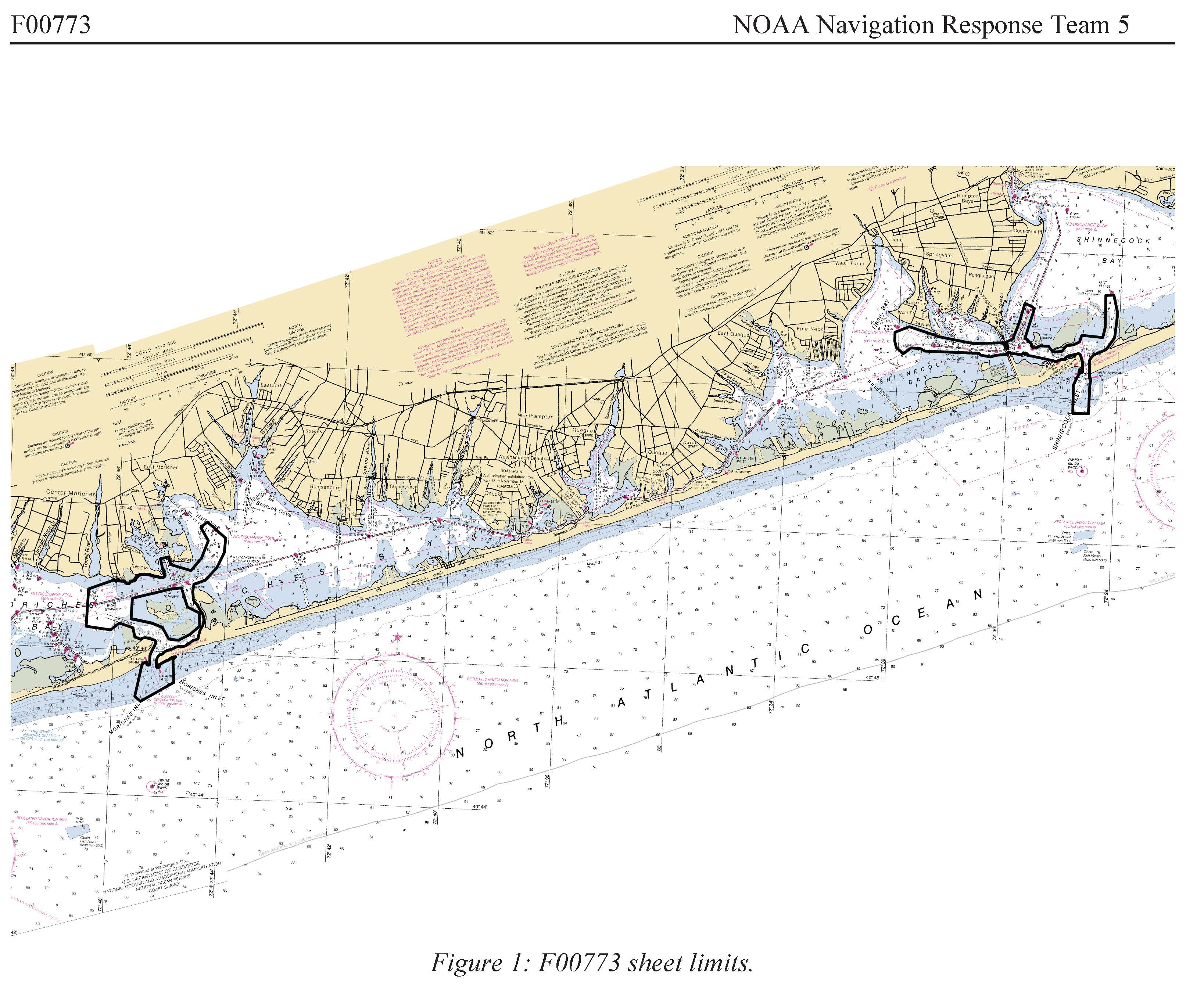
Federal
F00773: NOS Hydrographic Survey , 2019-06-07
National Oceanic and Atmospheric Administration, Department of Commerce —
The National Oceanic and Atmospheric Administration (NOAA) has the statutory mandate to collect hydrographic data in support of nautical chart compilation for safe...

Official websites use .gov
A
.gov website belongs to an official government
organization in the United States.
Secure .gov websites use HTTPS
A
lock (
) or https:// means you’ve safely connected to
the .gov website. Share sensitive information only on official,
secure websites.