
-
Federal
Military Special Use Airspace
National Oceanic and Atmospheric Administration, Department of Commerce —
Military Special Use Airspace is airspace of defined dimensions identified by an area on the surface of the earth wherein activities must be confined because of their... -
Federal
Volcanic Rocks and Features
National Oceanic and Atmospheric Administration, Department of Commerce —
Volcanoes have contributed significantly to the formation of the surface of our planet. Volcanism produced the crust we live on and most of the air we breathe. The... -
Federal
Global surface ocean pH, acidity, and Revelle Factor on a 1x1 degree global grid from 1770 to 2100 (NCEI Accession 0206289)
National Oceanic and Atmospheric Administration, Department of Commerce —
This dataset contains spatial distribution of surface ocean pH (total hydrogen scale), acidity (or hydrogen ion activity, unit: nmol/kg, or 10^-9 mol/kg) and Revelle... -
Federal
H06193: NOS Hydrographic Survey , 1937-12-31
National Oceanic and Atmospheric Administration, Department of Commerce —
The National Oceanic and Atmospheric Administration (NOAA) has the statutory mandate to collect hydrographic data in support of nautical chart compilation for safe... -
Federal
H13331: NOS Hydrographic Survey , 2019-10-17
National Oceanic and Atmospheric Administration, Department of Commerce —
The National Oceanic and Atmospheric Administration (NOAA) has the statutory mandate to collect hydrographic data in support of nautical chart compilation for safe... -
Federal
H12572: NOS Hydrographic Survey , Delaware Bay and Approaches, 2013-09-16
National Oceanic and Atmospheric Administration, Department of Commerce —
The National Oceanic and Atmospheric Administration (NOAA) has the statutory mandate to collect hydrographic data in support of nautical chart compilation for safe... -
Federal
F00646: NOS Hydrographic Survey , 2014-10-22
National Oceanic and Atmospheric Administration, Department of Commerce —
The National Oceanic and Atmospheric Administration (NOAA) has the statutory mandate to collect hydrographic data in support of nautical chart compilation for safe... -
Federal
Bathymetry 1m GRID of St. Thomas, US Virgin Islands, 2004, UTM 20 WGS84
National Oceanic and Atmospheric Administration, Department of Commerce —
This dataset contains an ESRI Grid with 1 meter cell size representing the bathymetry of the south shore of St. Thomas, US Virgin Islands. NOAA's NOS/NCCOS/CCMA... -
Federal
H07723: NOS Hydrographic Survey , 1950-12-31
National Oceanic and Atmospheric Administration, Department of Commerce —
The National Oceanic and Atmospheric Administration (NOAA) has the statutory mandate to collect hydrographic data in support of nautical chart compilation for safe... -
Federal
"LATEX CTD - d93f124.nc - 29.17N, 94.8W - 1993-08-02"
National Oceanic and Atmospheric Administration, Department of Commerce —
The Louisiana-Texas Shelf Physical Oceanography Program (LATEX) was sponsored by the Minerals Management Service (MMS) of the U.S. Department of the Interior. Of its... -
Federal
Temperature, salinity and currents data from CTD, ADCP and other instruments on R/V F.G. Walton Smith in the Florida and Loop Currents, 2007-05 to 2008-07 (NCEI Accession 0066847)
National Oceanic and Atmospheric Administration, Department of Commerce —
Oceanographic data were collected from a variety of sources during three cruises aboard the R/V Walton Smith (WS0714, cruise 1: May 29-June 14, 2007; WS0720, cruise... -
Federal
Long-Term Monitoring at the East and West Flower Garden Banks National Marine Sanctuary in the Gulf of Mexico, 2002-2006 (NCEI Accession 0012632)
National Oceanic and Atmospheric Administration, Department of Commerce —
The Long-Term Monitoring at the East and West Flower Garden Banks National Marine Sanctuary 2002-2006 data include biological and oceanographic measurements collected... -
Federal
Physical and meteorological data from the Tropical Atmosphere Ocean (TAO) array in the tropical Pacific Ocean
National Oceanic and Atmospheric Administration, Department of Commerce —
The Tropical Atmosphere Ocean (TAO) Array of 55 moored buoys spans the tropical Pacific from longitudes 165°E to 95°W between latitudes of approximately 8°S and... -
Federal
CTD, water quality, and pigment data collected from R/V Bellows cruise BE-1317 in the Gulf of Mexico from 2013-04-06 to 2013-04-08 (NCEI Accession 0160919)
National Oceanic and Atmospheric Administration, Department of Commerce —
This dataset reports conductivity, temperature, and depth data collected during R/V Bellows cruise BE-1317 of the offshore shelf of the Florida Panhandle Bight at the... -
Federal
Coral monitoring and growth change data from the Flower Garden Banks, Gulf of Mexico, 1998-1999 (NCEI Accession 0000736)
National Oceanic and Atmospheric Administration, Department of Commerce —
-
Federal
L01081: NOS Hydrographic Survey , 1903-12-31
National Oceanic and Atmospheric Administration, Department of Commerce —
The National Oceanic and Atmospheric Administration (NOAA) has the statutory mandate to collect hydrographic data in support of nautical chart compilation for safe... -
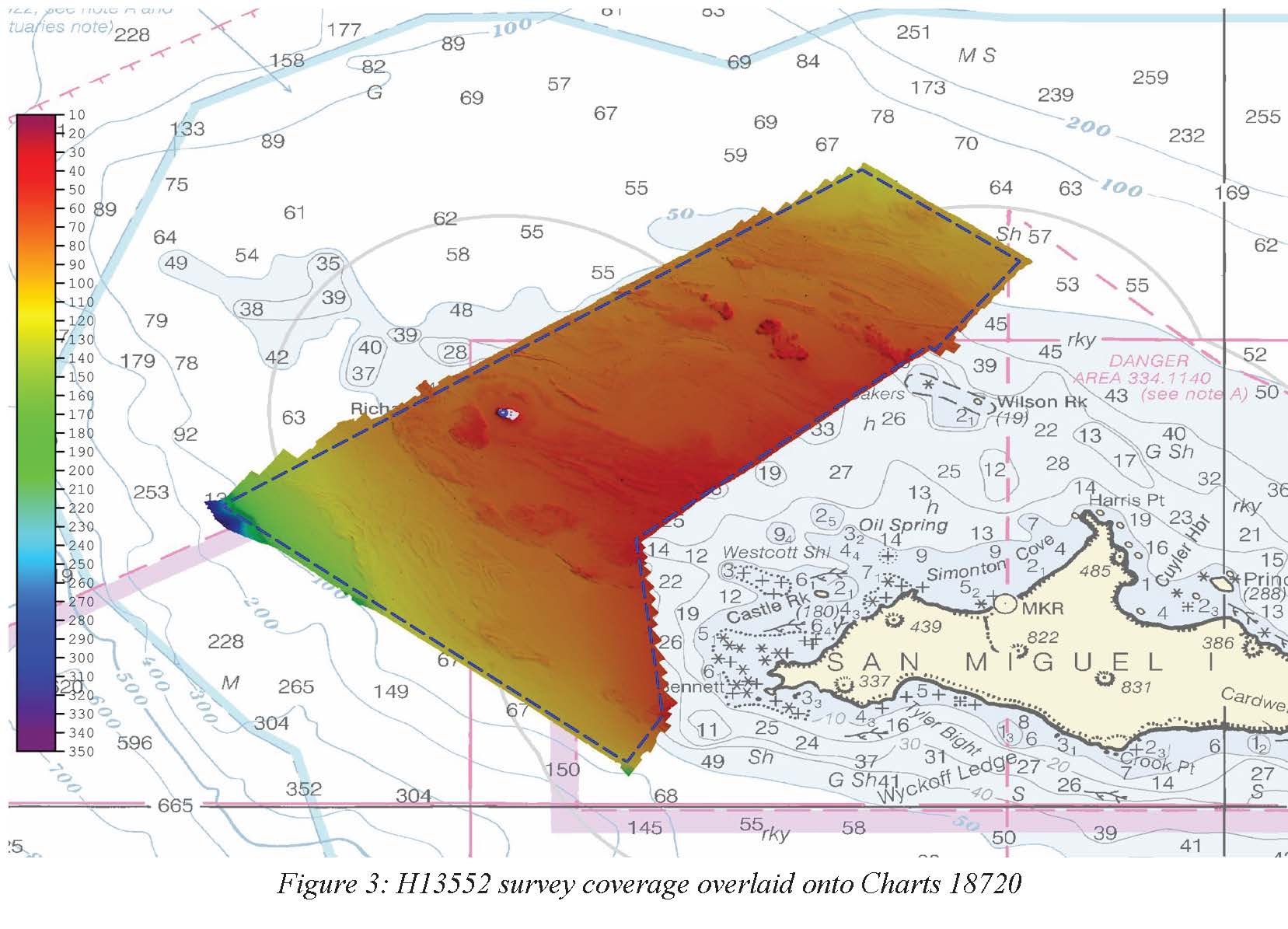
Federal
H13552: NOS Hydrographic Survey , 2021-10-07
National Oceanic and Atmospheric Administration, Department of Commerce —
The National Oceanic and Atmospheric Administration (NOAA) has the statutory mandate to collect hydrographic data in support of nautical chart compilation for safe... -
Federal
NOAA/WDS Paleoclimatology - Wilson - Gray Mountain (White Horse) - PCGL - ITRDB CANA598
National Oceanic and Atmospheric Administration, Department of Commerce —
This archived Paleoclimatology Study is available from the NOAA National Centers for Environmental Information (NCEI), under the World Data Service (WDS) for... -
Federal
B00169: NOS Hydrographic Survey , 1989-06-02
National Oceanic and Atmospheric Administration, Department of Commerce —
The National Oceanic and Atmospheric Administration (NOAA) has the statutory mandate to collect hydrographic data in support of nautical chart compilation for safe...

Official websites use .gov
A
.gov website belongs to an official government
organization in the United States.
Secure .gov websites use HTTPS
A
lock (
) or https:// means you’ve safely connected to
the .gov website. Share sensitive information only on official,
secure websites.