
-
Federal
H13441: NOS Hydrographic Survey , 2021-09-18
National Oceanic and Atmospheric Administration, Department of Commerce —
The National Oceanic and Atmospheric Administration (NOAA) has the statutory mandate to collect hydrographic data in support of nautical chart compilation for safe... -
Federal
H13318: NOS Hydrographic Survey , 2020-03-11
National Oceanic and Atmospheric Administration, Department of Commerce —
The National Oceanic and Atmospheric Administration (NOAA) has the statutory mandate to collect hydrographic data in support of nautical chart compilation for safe... -
Federal
H13304: NOS Hydrographic Survey , 2020-10-22
National Oceanic and Atmospheric Administration, Department of Commerce —
The National Oceanic and Atmospheric Administration (NOAA) has the statutory mandate to collect hydrographic data in support of nautical chart compilation for safe... -
Federal
W00684: NOS Hydrographic Survey , External Source Data 2023, 2022-11-17
National Oceanic and Atmospheric Administration, Department of Commerce —
The National Oceanic and Atmospheric Administration (NOAA) has the statutory mandate to collect hydrographic data in support of nautical chart compilation for safe... -
Federal
H13432: NOS Hydrographic Survey , 2021-06-23
National Oceanic and Atmospheric Administration, Department of Commerce —
The National Oceanic and Atmospheric Administration (NOAA) has the statutory mandate to collect hydrographic data in support of nautical chart compilation for safe... -
Federal
H13285: NOS Hydrographic Survey , 2019-11-26
National Oceanic and Atmospheric Administration, Department of Commerce —
The National Oceanic and Atmospheric Administration (NOAA) has the statutory mandate to collect hydrographic data in support of nautical chart compilation for safe... -
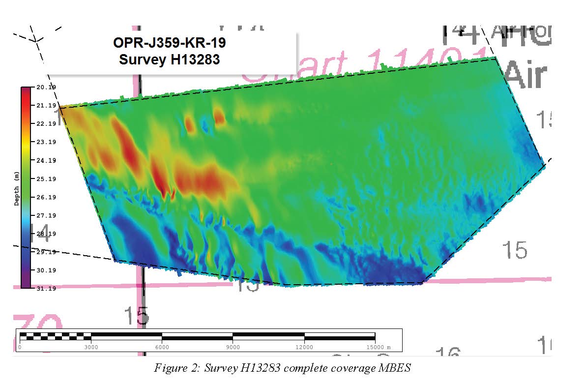
Federal
H13283: NOS Hydrographic Survey , 2019-11-26
National Oceanic and Atmospheric Administration, Department of Commerce —
The National Oceanic and Atmospheric Administration (NOAA) has the statutory mandate to collect hydrographic data in support of nautical chart compilation for safe... -
Federal
H13220: NOS Hydrographic Survey , 2019-09-29
National Oceanic and Atmospheric Administration, Department of Commerce —
The National Oceanic and Atmospheric Administration (NOAA) has the statutory mandate to collect hydrographic data in support of nautical chart compilation for safe... -
Federal
H13178: NOS Hydrographic Survey , 2019-07-24
National Oceanic and Atmospheric Administration, Department of Commerce —
The National Oceanic and Atmospheric Administration (NOAA) has the statutory mandate to collect hydrographic data in support of nautical chart compilation for safe... -
Federal
F00899: NOS Hydrographic Survey , Baltimore, MD, 2024-05-21
National Oceanic and Atmospheric Administration, Department of Commerce —
The National Oceanic and Atmospheric Administration (NOAA) has the statutory mandate to collect hydrographic data in support of nautical chart compilation for safe... -
Federal
September 1985 Mexico City, Mexico Images
National Oceanic and Atmospheric Administration, Department of Commerce —
The magnitude 8.1 earthquake occurred off the Pacific coast of Mexico. The damage was concentrated in a 25 square km area of Mexico City, 350 km from the epicenter.... -
Federal
MAPCO2 Buoy: Maihi Bay, Hawaii Island, Hawaii
National Oceanic and Atmospheric Administration, Department of Commerce —
This buoy is located in Maihi Bay approximately 200 meters offshore of the west coast of Hawaii Island just south of Kahaluu-Keauhou in the State of Hawaii. It is... -
Federal
2011 NOAA Ortho-rectified Mosaic of Casco Bay, Maine
National Oceanic and Atmospheric Administration, Department of Commerce —
This data set contains ortho-rectified mosaic tiles, created as a product from the NOAA Integrated Ocean and Coastal Mapping (IOCM) initiative. The source imagery was... -
Federal
2017 NOAA NGS Ortho-rectified Near-Infrared Mosaic of Green Bay, Wisconsin
National Oceanic and Atmospheric Administration, Department of Commerce —
This data set contains ortho-rectified mosaic tiles, created as a product from the NOAA Integrated Ocean and Coastal Mapping (IOCM) initiative. The source imagery was... -
Federal
2023 NOAA NGS MLLW Ortho-rectified 4-band Mosaic of Mississippi Sound, Mississippi
National Oceanic and Atmospheric Administration, Department of Commerce —
This data set contains 4-band ortho-rectified mosaic tiles, created as a product from the NOAA Integrated Ocean and Coastal Mapping (IOCM) initiative. They are 8 bit... -
Federal
2023 NOAA NGS Ortho-rectified 4-band Mosaic of Mobile, AL
National Oceanic and Atmospheric Administration, Department of Commerce —
This data set contains 4-band ortho-rectified mosaic tiles, created as a product from the NOAA Integrated Ocean and Coastal Mapping (IOCM) initiative. They are 8 bit... -
Federal
2021 NOAA NGS Ortho-rectified 4-band Mosaic of Southern Florida Bay, Florida
National Oceanic and Atmospheric Administration, Department of Commerce —
This data set contains ortho-rectified mosaic tiles, created as a product from the NOAA Integrated Ocean and Coastal Mapping (IOCM) initiative. The source imagery was... -
Federal
2023 NOAA NGS Ortho-rectified 4-band Mosaic of Dutch Harbor, AK
National Oceanic and Atmospheric Administration, Department of Commerce —
This data set contains 4-band ortho-rectified mosaic tiles, created as a product from the NOAA Integrated Ocean and Coastal Mapping (IOCM) initiative. The source... -
Federal
2022 NOAA NGS Ortho-rectified 4-band Mosaic of Rockland, ME
National Oceanic and Atmospheric Administration, Department of Commerce —
This data set contains 4-band ortho-rectified mosaic tiles, created as a product from the NOAA Integrated Ocean and Coastal Mapping (IOCM) initiative. The source... -
Federal
2023 NOAA NGS Ortho-rectified 4-band Mosaic of Pensacola, FL
National Oceanic and Atmospheric Administration, Department of Commerce —
This data set contains 4-band ortho-rectified mosaic tiles, created as a product from the NOAA Integrated Ocean and Coastal Mapping (IOCM) initiative. They are 8 bit...

Official websites use .gov
A
.gov website belongs to an official government
organization in the United States.
Secure .gov websites use HTTPS
A
lock (
) or https:// means you’ve safely connected to
the .gov website. Share sensitive information only on official,
secure websites.