
-
Federal
NACP North American Forest Dynamics Project: Forest Disturbance and Regrowth Data recent views
National Aeronautics and Space Administration —
This data set provides the results of time-series analyses of Landsat imagery for 55 selected forested sites across the conterminous U.S.A. The output is a pair of... -
Federal
Forest Inventory and Biophysical Measurements, Brazilian Amazon, 2009-2018 recent views
National Aeronautics and Space Administration —
This dataset provides the complete catalog of forest inventory and biophysical measurements collected over selected forest research sites across the Amazon rainforest... -
Federal
Arctic Vegetation Plots at Atqasuk, Alaska, 1975, 2000, and 2010 recent views
National Aeronautics and Space Administration —
This data set provides vegetation species abundance data collected in 1975 from 60 sites on the Arctic Coastal Plain near Atqasuk, Alaska, as well as environmental... -
Federal
NACP Site: Terrestrial Biosphere Model Output Data in Original Format recent views
National Aeronautics and Space Administration —
This data set contains the original model output data submissions from the 24 terrestrial biosphere models (TBM) that participated in the North American Carbon... -
Federal
NACP Site: Terrestrial Biosphere Model and Aggregated Flux Data in Standard Format recent views
National Aeronautics and Space Administration —
This data set provides standardized output variables for gross primary productivity (GPP), net ecosystem exchange (NEE), leaf area index (LAI), ecosystem respiration... -
Federal
Tree Mortality from Fires and Bark Beetles at 1-km Resolution, Western USA, 2003-2012 recent views
National Aeronautics and Space Administration —
This dataset provides annual estimates of tree mortality due to fires and bark beetles from 2003 to 2012 on forestland in the continental western United States. Tree... -
Federal
Fire Intensity and Burn Severity Metrics for Circumpolar Boreal Forests, 2001-2013 NGDA recent views
National Aeronautics and Space Administration —
This data set provides products characterizing immediate and longer-term ecosystem changes from fires in the circumpolar boreal forests of Northern Eurasia and North... -
Federal
BlueFlux: Dissolved Carbon and Greenhouse Gases recent views
National Aeronautics and Space Administration —
This dataset provides dissolved carbon (dissolved inorganic carbon and dissolved organic carbon), greenhouse gases, dissolved organic matter optical, and hydrological... -
Federal
PalEON: Terrestrial Ecosystem Model Drivers for the Northeastern U.S., 0850-2010 recent views
National Aeronautics and Space Administration —
This dataset from the PalEON Ecosystem Model Intercomparison Project (PEMIP) provides harmonized regional environmental and meteorological drivers at a resolution of... -
Federal
ABoVE: Photochemical Reflectance and Tree Growth, Brooks Range, Alaska, 2018-2019 recent views
National Aeronautics and Space Administration —
This dataset provides simultaneous in-situ measurements of the photochemical reflectance index (PRI) and radial tree growth of selected white spruce trees (Picea... -
Federal
Delta-X: Real-Time Kinematic Elevation Measurements for Coastal Wetlands, LA, 2021 recent views
National Aeronautics and Space Administration —
This dataset provides real-time kinematic (RTK) GPS elevation measurements, along with horizontal and vertical precision errors, obtained along transects near... -
Federal
ABoVE: Distribution Maps of Wildland Fire Fuel Components across Alaskan Tundra, 2015 recent views
National Aeronautics and Space Administration —
This dataset provides maps of the distribution of three major wildland fire fuel types at 30 m spatial resolution covering the Alaskan arctic tundra, circa 2015. The... -
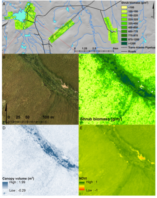
Federal
High-Resolution Shrub Biomass and Uncertainty Maps, Toolik Lake Area, Alaska, 2013 recent views
National Aeronautics and Space Administration —
This dataset contains estimates for aboveground shrub biomass and uncertainty at high spatial resolution (0.80-m) across three research areas near Toolik Lake,... -
Federal
Gross Primary Production Maps of Tidal Wetlands across Conterminous USA, 2000-2019 NGDA recent views
National Aeronautics and Space Administration —
This dataset provides mapped tidal wetland gross primary production (GPP) estimates (g C/m2/day) derived from multiple wetland types at 250-m resolution across the... -
Federal
NAFD-ATT Forest Canopy Cover Loss from Landsat, CONUS, 1986-2010 recent views
National Aeronautics and Space Administration —
Characterizing the cause of forest canopy changes through time is fundamental to understanding current and future forest functions. A better understanding of forest... -
Federal
Delta-X: AirSWOT L2 Geocoded Water Surface Elevation, MRD, Louisiana, 2021, Version 2 recent views
National Aeronautics and Space Administration —
This dataset contains Level 2 (L2) AirSWOT geocoded products, including estimated water surface elevation. The AirSWOT instrument is a Ka-band interferometer and for... -
Federal
ABoVE: Needle-Level Chlorophyll Fluorescence, Alaska and Idaho, USA, 2017 and 2019 recent views
National Aeronautics and Space Administration —
This dataset provides the results of in situ measurements of needle-level chlorophyll fluorescence (ChlF) obtained from a pulse amplitude modulated (PAM) fluorometer... -
Federal
ABoVE: Thaw Depth at Selected Unburned and Burned Sites Across Alaska recent views
National Aeronautics and Space Administration —
This dataset provides thaw depth measurements made at seven locations across Alaska, during August 2016, June and September 2017, and July-August 2018. Three of the... -
Federal
Net Radiation and Albedo from MODIS for Xingu River Basin, Brazil, 2000-2012 NGDA recent views
National Aeronautics and Space Administration —
This dataset provides daily average land surface net radiation (Rnet) as an 8-day time series at approximately 0.5 km resolution for the upper Xingu River Basin in... -
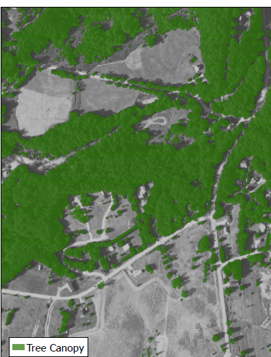
Federal
CMS: Tree Canopy Cover at 0.5-meter resolution, Vermont, 2016 recent views
National Aeronautics and Space Administration —
This dataset contains estimates of tree canopy cover presence at high resolution (0.5m) across the state of Vermont for 2016 in Cloud-Optimized GeoTIFF (*.tif)...

Official websites use .gov
A
.gov website belongs to an official government
organization in the United States.
Secure .gov websites use HTTPS
A
lock (
) or https:// means you’ve safely connected to
the .gov website. Share sensitive information only on official,
secure websites.