
-
Federal
Sources of Methane Emissions (Vista-CA), State of California, USA recent views
National Aeronautics and Space Administration —
This dataset provides spatial data products with identified and organized locations of potential methane (CH4) emitting facilities and infrastructure spanning the... -
Federal
GRIP HURRICANE IMAGING RADIOMETER (HIRAD) V1 recent views
National Aeronautics and Space Administration —
The GRIP Hurricane Imaging Radiometer (HIRAD) V1 dataset contains measurements of brightness temperature taken at 4, 5, 6 and 6.6 GHz, as well as MERRA 2 m wind speed... -
Federal
NARSTO EPA Supersite (SS) Houston, Texas Air Quality Study 2000 (TexAQS2000) Department of Energy (DOE) G-1 Air Chemistry, Aerosol, and Met Data recent views
National Aeronautics and Space Administration —
NARSTO_EPA_SS_HOUSTON_TEXAQS2000_DOE_G-1_DATA is North American Research Strategy for Tropospheric Ozone (NARSTO) Environmental Protection Agency (EPA) Supersite (SS)... -
Federal
NARSTO EPA Supersite (SS) Atlanta 1999 Air Chemistry, Particulate Matter (PM), and Meteorological Data recent views
National Aeronautics and Space Administration —
The NARSTO_EPA_SS_ATLANTA_1999_CHEM_PM_MET_DATA is the North American Research Strategy for Tropospheric Ozone (NARSTO) Environmental Protection Agency (EPA)... -
Federal
ABoVE: Dall Sheep Lamb Recruitment and Climate Data, Alaska and NW Canada, 2000-2015 NGDA recent views
National Aeronautics and Space Administration —
This dataset contains estimated annual average Dall sheep (Ovis dalli dalli) lamb-to-ewe ratios for each year from 2000-2015 across the full species range in Alaska... -
Federal
NARSTO EPA Supersite (SS) Atlanta 1999 Rapid Single-Particle Mass Spectrometer (SPMS) Data. recent views
National Aeronautics and Space Administration —
NARSTO_EPA_SS_ATLANTA_RAPID_SPMS_DATA is the North American Research Strategy for Tropospheric Ozone (NARSTO) Environmental Protection Agency (EPA) Supersite (SS)... -
Federal
ABoVE: Directory of Field Sites Associated with 2017 ABoVE Airborne Campaign recent views
National Aeronautics and Space Administration —
This dataset provides a listing of the ~6,700 field sites used in planning the ABoVE Airborne Campaign (AAC) for 2017. The sites included point, polygon, and line... -
Federal
NACP Greenhouse Gases Multi-Source Data Compilation, 2000-2009 recent views
National Aeronautics and Space Administration —
This data set is a collection of measurements of carbon dioxide (CO2) and non-CO2 greenhouse gases made across North America by nine independent atmospheric... -
Federal
CERES and MISR Along-Track Footprint Radiances, Fluxes, and Clouds Terra-FM1 NGDA recent views
National Aeronautics and Space Administration —
CERES-MISR-MODIS_SSF-SSFM_Terra-FM1_1 is the Clouds and the Earth's Radiant Energy System (CERES) and Multi-angle Imaging SpectroRadiometer (MISR) Along-Track... -
Federal
CERES and MISR Along-Track Footprint Radiances, Fluxes, and Clouds Terra-FM2 NGDA recent views
National Aeronautics and Space Administration —
CERES-MISR-MODIS_SSF-SSFM_Terra-FM2_1 is the is the Clouds and the Earth's Radiant Energy System (CERES) and Multi-angle Imaging SpectroRadiometer (MISR) Along-Track... -
Federal
FLUXNET Research Network Site Characteristics, Investigators, and Bibliography, 2016 recent views
National Aeronautics and Space Administration —
FLUXNET is a global network of micrometeorological tower sites that use eddy covariance methods to measure the exchanges of carbon dioxide, water vapor, and energy... -
Federal
NARSTO EPA Supersite (SS) Los Angeles Size-Fractionated Particulate Matter (PM) Composition - micro-orifice uniform deposit impactors (MOUDI) Data recent views
National Aeronautics and Space Administration —
The NARSTO_EPA_SS_LOS_ANGELES_MOUDI_DATA is the North American Research Strategy for Tropospheric Ozone (NARSTO) Environmental Protection Agency (EPA) Supersite (SS)... -
Federal
MISR Level 3 Cloud Fraction by Altitude Product covering a month V001 recent views
National Aeronautics and Space Administration —
MIL3MCFA_1 is the Multi-angle Imaging SpectroRadiometer (MISR) Level 3 Cloud Fraction by Altitude Product covering a month version 1. It provides the frequency of... -
Federal
MISR Level 3 Global Joint Aerosol monthly product V002 recent views
National Aeronautics and Space Administration —
MIL3MJTA_2 is the Multi-angle Imaging SpectroRadiometer (MISR) Level 3 Global Joint Aerosol monthly product version 2 data product. It contains global statistical... -
Federal
MISR Level 3 Component Global Aerosol Product covering a day V004 recent views
National Aeronautics and Space Administration —
MIL3DAE_4 is the Multi-angle Imaging SpectroRadiometer (MISR) Level 3 Component Global Aerosol Product covering a day version 4. It contains a statistical summary of... -
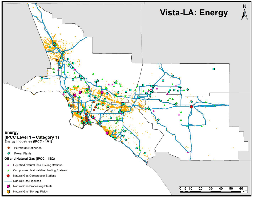
Federal
Sources of Methane Emissions (Vista-LA), South Coast Air Basin, California, USA recent views
National Aeronautics and Space Administration —
This data set provides spatial data products with identified and classified locations of potential methane (CH4) emitting facilities and infrastructure in the South... -
Federal
MISR Level 3 Cloud Motion Vector yearly Product in netCDF format V002 recent views
National Aeronautics and Space Administration —
MI3YCMVN_2 is the Multi-angle Imaging SpectroRadiometer (MISR) Level 3 Cloud Motion Vector yearly Product in netCDF format version 2. It contains retrievals of cloud... -
Federal
ABoVE: SAR-based Methane Ebullition Flux from Lakes, Five Regions, Alaska, 2007-2010 recent views
National Aeronautics and Space Administration —
This dataset provides Synthetic Aperture Radar (SAR) estimates of lake-source methane ebullition flux in mg CH4/m2/d for thousands of lakes in five regions across... -
Federal
Airborne Multi-angle Imaging SpectroRadiometer (AirMISR) Data from the Howland 2003 Campaign recent views
National Aeronautics and Space Administration —
The AIRMISR_HOWLAND_2003 data were acquired during a field mission which overflew Howland Forest, Maine on August 28, 2003. The Jet Propulsion Laboratory (JPL) in... -
Federal
MISR Level 3 Component Global Aerosol Regional public Product covering a month V002 recent views
National Aeronautics and Space Administration —
MI3MAER_2 is the Multi-angle Imaging SpectroRadiometer (MISR) Level 3 Component Global Aerosol Regional public Product covering a month version 2. It contains a...

Official websites use .gov
A
.gov website belongs to an official government
organization in the United States.
Secure .gov websites use HTTPS
A
lock (
) or https:// means you’ve safely connected to
the .gov website. Share sensitive information only on official,
secure websites.