
-
Federal
National Agriculture Imagery Program (NAIP) 42 recent views
National Aeronautics and Space Administration —
The National Agriculture Imagery Program (NAIP) acquires aerial imagery during the agricultural growing seasons in the continental U.S. A primary goal of the NAIP... -
Federal
Global Hyperspectral Imaging Spectral-library of Agricultural crops for Conterminous United States V001 36 recent views
National Aeronautics and Space Administration —
The Global Hyperspectral Imaging Spectral-library of Agricultural crops (GHISA) is a comprehensive compilation, collation, harmonization, and standardization of... -
Federal
Ocean Surface Current Analyses Real-time (OSCAR) Surface Currents - Final 0.25 Degree (Version 2.0) 33 recent views
National Aeronautics and Space Administration —
Ocean Surface Current Analyses Real-time (OSCAR) is a global surface current database and NASA funded research project. OSCAR ocean mixed layer velocities are... -
Federal
NASA Enterprise Data Inventory (EDI) 19 recent views
National Aeronautics and Space Administration —
EDI Redaction letter -
Federal
NACP North American Forest Dynamics Project: Forest Disturbance and Regrowth Data 17 recent views
National Aeronautics and Space Administration —
This data set provides the results of time-series analyses of Landsat imagery for 55 selected forested sites across the conterminous U.S.A. The output is a pair of... -
Federal
CALIPSO Lidar Level 2 Cloud Profile, V4-20 13 recent views
National Aeronautics and Space Administration —
CAL_LID_L2_05kmCPro-Standard-V4-20 is the Cloud-Aerosol Lidar and Infrared Pathfinder Satellite Observations (CALIPSO) Lidar Level 2 Cloud Profile, Version 4-20 data... -
Federal
GPM IMERG Final Precipitation L3 1 day 0.1 degree x 0.1 degree V06 (GPM_3IMERGDF) at GES DISC 12 recent views
National Aeronautics and Space Administration —
The Integrated Multi-satellitE Retrievals for GPM (IMERG) is the unified U.S. algorithm that provides the multi-satellite precipitation product for the U.S. GPM team.... -
Federal
Aviation Safety Reporting System: Maintenance Reports 12 recent views
National Aeronautics and Space Administration —
A sampling of reports from aircraft maintenance personnel. -
Federal
GPM IMERG Final Precipitation L3 Half Hourly 0.1 degree x 0.1 degree V07 (GPM_3IMERGHH) at GES DISC 11 recent views
National Aeronautics and Space Administration —
Version 07 is the current version of the data set. Older versions will no longer be available and have been superseded by Version 07. The Integrated Multi-satellitE... -
Federal
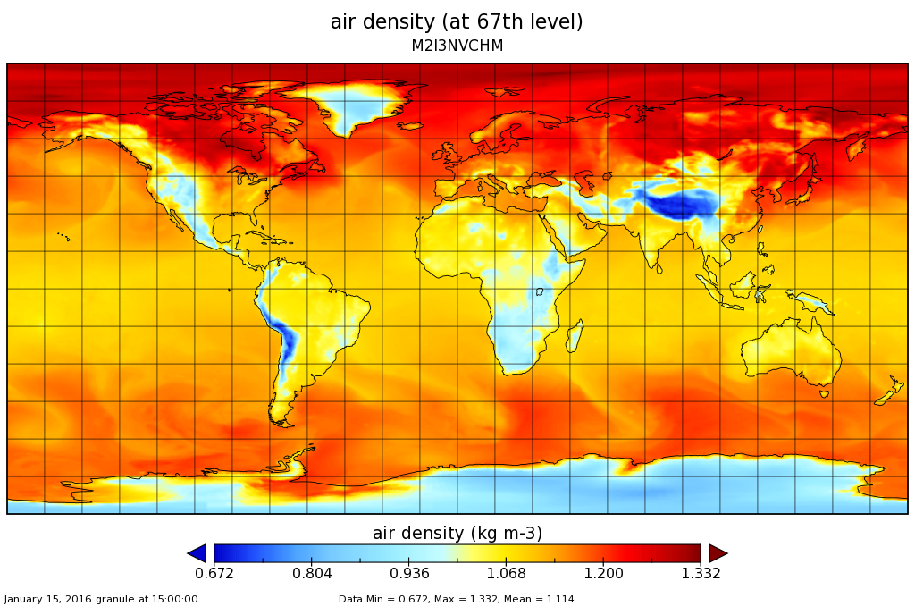
MERRA-2 inst3_3d_chm_Nv: 3d,3-Hourly,Instantaneous,Model-Level,Assimilation,Carbon Monoxide and Ozone Mixing Ratio 0.625 x 0.5 degree V5.12.4 (M2I3NVCHM) at GES DISC 10 recent views
National Aeronautics and Space Administration —
M2I3NVCHM (or inst3_3d_chm_Nv) is an instantaneous 3-dimensional 3-hourly data collection in Modern-Era Retrospective analysis for Research and Applications version 2... -
Federal
TRMM (TMPA) Rainfall Estimate L3 3 hour 0.25 degree x 0.25 degree V7 (TRMM_3B42) at GES DISC 10 recent views
National Aeronautics and Space Administration —
TMPA (3B42) dataset have been discontinued as of Dec. 31, 2019, and users are strongly encouraged to shift to the successor IMERG dataset (doi:... -
Federal
TES/Aura L1B Spectra Nadir V006 10 recent views
National Aeronautics and Space Administration —
TL1BN_6 is the Tropospheric Emission Spectrometer (TES)/Aura L1B Spectra Nadir Version 6 data product. TES was an instrument aboard NASA's Aura satellite and was... -
Federal
MODIS/Terra Temperature and Water Vapor Profiles 5-Min L2 Swath 5km NGDA 10 recent views
National Aeronautics and Space Administration —
The MODIS/Terra Temperature and Water Vapor Profiles 5-Min L2 Swath 5km (MOD07_L2) product consists of a numbers of parameters related to atmospheric stability,... -
Federal
ECCO Ocean Temperature and Salinity - Daily Mean 0.5 Degree (Version 4 Release 4)
National Aeronautics and Space Administration —
This dataset contains daily-averaged ocean potential temperature and salinity interpolated to a regular 0.5-degree grid from the ECCO Version 4 revision 4 (V4r4)... -
Federal
Classification
National Aeronautics and Space Administration —
A supervised learning task involves constructing a mapping from an input data space (normally described by several features) to an output space. A set of training... -
Federal
Decadal Land Use and Land Cover Classifications across India, 1985, 1995, 2005
National Aeronautics and Space Administration —
This data set provides land use and land cover (LULC) classification products at 100-m resolution for India at decadal intervals for 1985, 1995 and 2005. The data... -
Federal
GPM IMERG Late Precipitation L3 Half Hourly 0.1 degree x 0.1 degree V06 (GPM_3IMERGHHL) at GES DISC
National Aeronautics and Space Administration —
The Integrated Multi-satellitE Retrievals for GPM (IMERG) is the unified U.S. algorithm that provides the multi-satellite precipitation product for the U.S. GPM team.... -
Federal
MODIS/Terra Gap-Filled, Smoothed NDVI 8-Day L4 500m SIN Grid NGDA
National Aeronautics and Space Administration —
The MODIS/Terra Gap-Filled, Smoothed NDVI 8-Day L4 500m SIN Grid product, with short-name MOD09A1G_NDVI is calculated from MODIS surface reflectance products (MOD09),... -
Federal
Global Fire Emissions Database, Version 4.1 (GFEDv4) NGDA
National Aeronautics and Space Administration —
This dataset provides global estimates of monthly burned area, monthly emissions and fractional contributions of different fire types, daily or 3-hourly fields to... -
Federal
CYGNSS Level 1 Science Data Record Version 3.2
National Aeronautics and Space Administration —
This CYGNSS Level 1 (L1) science data record dataset contains the version 3.2 geo-located Delay Doppler Maps (DDMs) calibrated into Power Received (Watts) and...

Official websites use .gov
A
.gov website belongs to an official government
organization in the United States.
Secure .gov websites use HTTPS
A
lock (
) or https:// means you’ve safely connected to
the .gov website. Share sensitive information only on official,
secure websites.