
-
Federal
Global Flood Hazard Frequency and Distribution
National Aeronautics and Space Administration —
The Global Flood Hazard Frequency and Distribution is a 2.5 minute grid derived from a global listing of extreme flood events between 1985 and 2003 (poor or missing... -
Federal
GPM Ground Validation Global Flood Monitoring System (GFMS) Flood Maps IFloodS V1
National Aeronautics and Space Administration —
The GPM Ground Validation Global Flood Monitoring System (GFMS) Flood Maps IFloodS dataset contains global flood estimates on a 0.25 degree spatial resolution every 3... -
Federal
SWOT Level 2 Water Mask Pixel Cloud Data Product, Version D
National Aeronautics and Space Administration —
The SWOT Level 2 Water Mask Pixel Cloud Product (SWOT_L2_HR_PIXC_D) provides high-resolution, geolocated observations of terrestrial surface water pixels detected by... -
Federal
GPM GROUND VALIDATION NEXRAD LEVEL II KDVN IFLOODS V1
National Aeronautics and Space Administration —
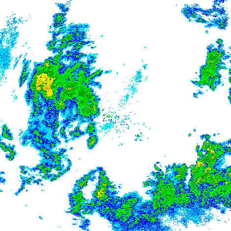
The GPM Ground Validation Next Generation Weather Radar (NEXRAD) Level II IFloodS datasets were collected from four sites (see Table 1) from March 29, 2013 to June... -
Federal
Land Use and Cover Maps from Landsat, Mawas, Central Kalimantan, Indonesia, 1994-2019
National Aeronautics and Space Administration —
This dataset contains annual land use/cover (LUC) maps at 30 m resolution across Mawas, Central Kalimantan, Indonesia. There are six files, each representing a five-... -
Federal
LBA-ECO LC-04 THMB Model Simulations for the Amazon and Tocantins Basins: 1939-1998
National Aeronautics and Space Administration —
The model output data provided were generated by the THMB 1.2 (Terrestrial Hydrology Model with Biogeochemistry) model which simulates the flow of water through... -
Federal
GPM Ground Validation Goddard Profiling Algorithm (GPROF) 2014 IFloodS V3
National Aeronautics and Space Administration —
The GPM Ground Validation Goddard Profiling Algorithm (GPROF) 2014 IFloodS dataset consists of precipitation data derived from microwave radiometers and sounders... -
Federal
Groundswell Spatial Population and Migration Projections at One-Eighth Degree According to SSPs and RCPs, 2010-2050
National Aeronautics and Space Administration —
The Groundswell Spatial Population and Migration Projections at One-Eighth Degree According to SSPs and RCPs, 2010-2050, data set provides a baseline population... -
Federal
LBA-ECO LC-07 CO2 and CH4 Flux from Wetlands, Negro River Basin, Brazil: 2004-2006
National Aeronautics and Space Administration —
This data set provides estimates of daily and monthly carbon dioxide (CO2) and methane (CH4) diffusive and ebullitive flux for dry and flooded areas from two study... -
Federal
Global Multihazard Mortality Risks and Distribution
National Aeronautics and Space Administration —
The Global Multihazard Mortality Risks and Distribution is a 2.5 minute grid identifying and characterizing the nature of multihazard risk at the global scale. For... -
Federal
GPM GROUND VALIDATION NASA S-BAND DUAL POLARIMETRIC (NPOL) DOPPLER RADAR IFLOODS V2
National Aeronautics and Space Administration —
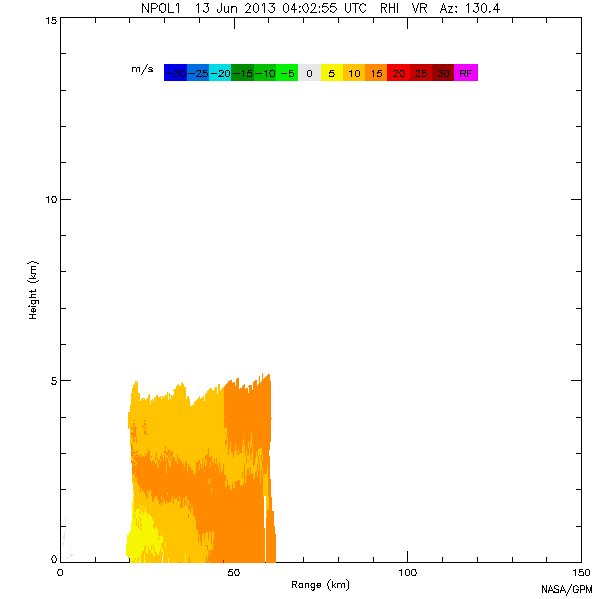
The GPM Ground Validation NASA S-Band Dual Polarimetric (NPOL) Doppler Radar IFloodS dataset was collected from April 30 to June 16, 2013 near Traer, Iowa as part of... -
Federal
GPM Ground Validation USGS Stream Flow IFloodS V1
National Aeronautics and Space Administration —
The GPM Ground Validation USGS Stream Flow IFloodS dataset was obtained from USGS during the Iowa Flood Studies (IFloodS) field campaign that extended from March 30,... -
Federal
Global Multihazard Total Economic Loss Risk Deciles
National Aeronautics and Space Administration —
The Global Multihazard Total Economic Loss Risk Deciles is a 2.5 minute grid of global multihazard total economic loss risks. First, for each of the considered... -
Federal
GPM Ground Validation NEXRAD Level III KDVN IFloodS
National Aeronautics and Space Administration —
The GPM Ground Validation NEXRAD Level III KDVN IFloodS dataset contain precipitation products derived from selected NEXt Generation Weather RADar system (NEXRAD)... -
Federal
LBA-ECO CD-06 Flux of CO2 from Amazon Mainstem Rivers, Tributaries, and Floodplains
National Aeronautics and Space Administration —
This data set provides estimates of monthly carbon dioxide (CO2) flux from the Amazon mainstem rivers, tributary stream networks, and their associated varzeas... -
Federal
Summary Report of Community-Based Environmental and Species Observations from the Bering Sea Sub-Network, 2008-2009, Version 1
National Aeronautics and Space Administration —
The Bering Sea Sub-Network (BSSN) is comprised of a set of coastal communities representing six indigenous cultures: three in the Russian Federation and three in the... -
Federal
LBA-ECO LC-07 Bathymetric Survey of Floodplain Lake, Lago Curuai, Para, Brazil: 2004
National Aeronautics and Space Administration —
The bathymetry data provided represent a continuous surface of interpolated point measurements of depth values of Lago Curuai, an Amazon River floodplain lake,... -
Federal
High Mountain Asia 30m and 8m Flood Geomorphic Potential V001
National Aeronautics and Space Administration —
This data set contains Flood Geomorphic Potential (FGP) at 30 m resolution for the High Mountain Asia region and 8 m resolution over Nepal. FGP is a digital elevation... -
Federal
GPM Ground Validation NEXRAD Level III KDVN IFloodS V1
National Aeronautics and Space Administration —
The GPM Ground Validation NEXRAD Level III KDVN IFloodS dataset contain precipitation products derived from selected NEXt Generation Weather RADar system (NEXRAD)... -
Federal
GPM GROUND VALIDATION NEXRAD LEVEL II KMPX IFLOODS
National Aeronautics and Space Administration —
The GPM Ground Validation Next Generation Weather Radar (NEXRAD) Level II IFloodS datasets were collected from four sites (see Table 1) from March 29, 2013 to June...

Official websites use .gov
A
.gov website belongs to an official government
organization in the United States.
Secure .gov websites use HTTPS
A
lock (
) or https:// means you’ve safely connected to
the .gov website. Share sensitive information only on official,
secure websites.