
-
Federal
Global Flood Hazard Frequency and Distribution
National Aeronautics and Space Administration —
The Global Flood Hazard Frequency and Distribution is a 2.5 minute grid derived from a global listing of extreme flood events between 1985 and 2003 (poor or missing... -
Federal
Land Use and Cover Maps from Landsat, Mawas, Central Kalimantan, Indonesia, 1994-2019
National Aeronautics and Space Administration —
This dataset contains annual land use/cover (LUC) maps at 30 m resolution across Mawas, Central Kalimantan, Indonesia. There are six files, each representing a five-... -
Federal
Global Multihazard Frequency and Distribution
National Aeronautics and Space Administration —
The Global Multihazard Frequency and Distribution is a 2.5 minute grid presenting a simple multihazard index based solely on summated single-hazard decile values. The... -
Federal
GPM Ground Validation Global Flood Monitoring System (GFMS) Flood Maps IFloodS V1
National Aeronautics and Space Administration —
The GPM Ground Validation Global Flood Monitoring System (GFMS) Flood Maps IFloodS dataset contains global flood estimates on a 0.25 degree spatial resolution every 3... -
Federal
Geocoded Disasters (GDIS) Dataset
National Aeronautics and Space Administration —
The Geocoded Disasters (GDIS) Dataset is a geocoded extension of a selection of natural disasters from the Centre for Research on the Epidemiology of Disasters'... -
Federal
GPM GROUND VALIDATION TWO-DIMENSIONAL VIDEO DISDROMETER (2DVD) IFLOODS V1
National Aeronautics and Space Administration —
The GPM Ground Validation Two-Dimensional Video Disdrometer (2DVD) IFloodS dataset was collected during the GPM Ground Validation Iowa Flood Studies (IFLoodS) field... -
Federal
SWOT Level 2 Water Mask Pixel Cloud Data Product, Version D
National Aeronautics and Space Administration —
The SWOT Level 2 Water Mask Pixel Cloud Product (SWOT_L2_HR_PIXC_D) provides high-resolution, geolocated observations of terrestrial surface water pixels detected by... -
Federal
Burn Scar - Corrected Reflectance (VIIRS / Suomi-NPP)
National Aeronautics and Space Administration —
This visualization represents a "false color" band combination (M11-I2-I1 | Red-Green-Blue) of data collected by the VIIRS instrument on the Suomi-NPP satellite and... -
Federal
Global Flood Proportional Economic Loss Risk Deciles
National Aeronautics and Space Administration —
The Global Flood Proportional Economic Loss Risk Deciles is a 2.5 minute grid of flood hazard economic loss as proportions of Gross Domestic Product (GDP) per... -
Federal
Mirador - Earth Surface and Interior
National Aeronautics and Space Administration —
Earth Science data access made simple. The goal of the Earth Surface and Interior focus area is to assess, mitigate and forecast the natural hazards that affect... -
Federal
GPM GROUND VALIDATION MET ONE RAIN GAUGE PAIRS IFLOODS V2
National Aeronautics and Space Administration —
The GPM Ground Validation Met One Rain Gauge Pairs IFloodS V2 data measures the amount of fallen precipitation collected by a Model 380 tipping bucket rain gauge made... -
Federal
MODIS/Aqua+Terra Global Flood Product L3 NRT 250m 1-day CS GeoTIFF
National Aeronautics and Space Administration —
The MODIS/Aqua+Terra Global Flood Product L3 Near Real Time (NRT) 250m 1-day CS GeoTIFF Product (MCDWD_L3_F1C_NRT) (beta) provides daily maps of flooding globally.... -
Federal
GPM Ground Validation National Mosaic and Multi-Sensor QPE (NMQ) System IFloodS V1
National Aeronautics and Space Administration —
The GPM Ground Validation National Mosaic and Multi-Sensor QPE (NMQ) System IFloodS dataset contains quality control products, real time rain rate estimates, hourly... -
Federal
LBA-ECO LC-04 THMB Model Simulations for the Amazon and Tocantins Basins: 1939-1998
National Aeronautics and Space Administration —
The model output data provided were generated by the THMB 1.2 (Terrestrial Hydrology Model with Biogeochemistry) model which simulates the flow of water through... -
Federal
MODIS/Aqua+Terra Global Flood Product L3 NRT 250m 2-day GeoTIFF
National Aeronautics and Space Administration —
The MODIS/Aqua+Terra Global Flood Product L3 Near Real Time (NRT) 250m 2-day GeoTIFF Product (MCDWD_L3_F2_NRT) (beta) provides maps of flooding globally. The Global... -
Federal
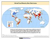
Global Flood Mortality Risks and Distribution
National Aeronautics and Space Administration —
The Global Flood Mortality Risks and Distribution is a 2.5 minute grid of global flood mortality risks. Gridded Population of the World, Version 3 (GPWv3) data... -
Federal
GPM Ground Validation Goddard Profiling Algorithm (GPROF) 2014 IFloodS V3
National Aeronautics and Space Administration —
The GPM Ground Validation Goddard Profiling Algorithm (GPROF) 2014 IFloodS dataset consists of precipitation data derived from microwave radiometers and sounders... -
Federal
Groundswell Spatial Population and Migration Projections at One-Eighth Degree According to SSPs and RCPs, 2010-2050
National Aeronautics and Space Administration —
The Groundswell Spatial Population and Migration Projections at One-Eighth Degree According to SSPs and RCPs, 2010-2050, data set provides a baseline population... -
Federal
LBA-ECO LC-07 CO2 and CH4 Flux from Wetlands, Negro River Basin, Brazil: 2004-2006
National Aeronautics and Space Administration —
This data set provides estimates of daily and monthly carbon dioxide (CO2) and methane (CH4) diffusive and ebullitive flux for dry and flooded areas from two study... -
Federal
Global Multihazard Mortality Risks and Distribution
National Aeronautics and Space Administration —
The Global Multihazard Mortality Risks and Distribution is a 2.5 minute grid identifying and characterizing the nature of multihazard risk at the global scale. For...

Official websites use .gov
A
.gov website belongs to an official government
organization in the United States.
Secure .gov websites use HTTPS
A
lock (
) or https:// means you’ve safely connected to
the .gov website. Share sensitive information only on official,
secure websites.