
-
Federal
Global 1-km Gridded Thickness of Soil, Regolith, and Sedimentary Deposit Layers
National Aeronautics and Space Administration —
This data set provides high-resolution estimates of the thickness of the permeable layers above bedrock (soil, regolith, and sedimentary deposits) within a global... -
Federal
EMIT L2B Estimated Mineral Identification and Band Depth and Uncertainty 60 m V001
National Aeronautics and Space Administration —
The Earth Surface Mineral Dust Source Investigation (EMIT) instrument measures surface mineralogy, targeting the Earth’s arid dust source regions. EMIT is installed... -
Federal
SAFARI 2000 Aerosol Fatty Acid and Stable Isotope Data, Mongu, Dry Season 2000
National Aeronautics and Space Administration —
The Southern African Regional Science Initiative (SAFARI 2000) was conducted in part to investigate the impacts of the large-scale transport and deposition of... -
Federal
SAFARI 2000 C-130 Aerosol and Meteorological Data, Dry Season 2000
National Aeronautics and Space Administration —
The Met Office C-130 research aircraft was based at Windhoek, Namibia between September 5-16, 2000, where it conducted a series of flights over Namibia as part of the... -
Federal
Pre-LBA ABLE-2A and ABLE-2B Expedition Data
National Aeronautics and Space Administration —
The ABLE 2A and 2B (Atmospheric Boundary Layer Experiments) data consists of estimates of the rate of exchange of a wide variety of aerosols and gases between the... -
Federal
CERES and GEO-Enhanced TOA, Within-Atmosphere and Surface Fluxes, Clouds and Aerosols Daily Terra-NPP Edition1A
National Aeronautics and Space Administration —
CER_SYN1deg-Day_Terra-NPP_Edition1A is the Clouds and the Earth's Radiant Energy System (CERES) and geostationary (GEO)-Enhanced Top-of-Atmosphere (TOA) and Surface... -
Federal
BOREAS TGB-10 Oxidant Flux Data over the SSA
National Aeronautics and Space Administration —
The BOREAS TGB-10 team collected several trace gas data sets in their efforts to determine the role of biogenic hydrocarbon emissions with respect to boreal forest... -
Federal
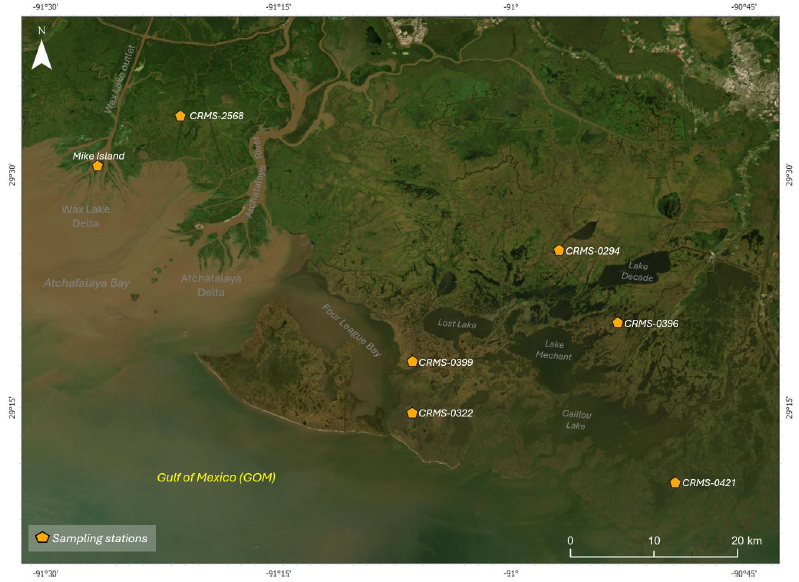
Delta-X: Soil Accretion Rates from Cs-137 Activity and NUMAR Validation, MRD, LA
National Aeronautics and Space Administration —
This dataset holds measurements of Cesium-137 (137Cs) activity sampled from sites in the Atchafalaya and Terrebonne Basins on the southern coast of Louisiana, USA.... -
Federal
NACP MsTMIP: Global and North American Driver Data for Multi-Model Intercomparison
National Aeronautics and Space Administration —
This data set provides environmental data that have been standardized and aggregated for use as input to carbon cycle models at global (0.5-degree resolution) and... -
Federal
VEMAP 2: U.S. Monthly Climate, 1895-1993, Version 2
National Aeronautics and Space Administration —
The Vegetation/Ecosystem Modeling and Analysis Project (VEMAP) Phase 2 has developed a data set of ~100-year gridded monthly and daily time series of climate for the... -
Federal
SAFARI 2000 Tree Cover from AVHRR, 1-km, 1992-1993 (DeFries et al.)
National Aeronautics and Space Administration —
The data set consists of a southern Africa subset of the 1km Global Tree Cover Data Set developed at the Laboratory for Global Remote Sensing Studies (LGRSS) at the... -
Federal
SAFARI 2000 AERONET Ground-based Aerosol Data, Dry Season 2000
National Aeronautics and Space Administration —
AERONET (AErosol RObotic NETwork) is an optical ground-based aerosol monitoring network and data archive system. AERONET measurements of the column-integrated aerosol... -
Federal
Nitrogen Deposition onto the United States and Western Europe
National Aeronautics and Space Administration —
This data set contains data for wet and dry nitrogen-species deposition for the United States and Western Europe. Deposition data were acquired directly from... -
Federal
FLEXPART black carbon aerosol L4 global daily 1 x 1 degrees V1 (BCFLEXPART)
National Aeronautics and Space Administration —
This is a global simulation of black carbon (BC) aerosol concentrations and daily deposition (wet+dry) from the FLEX-ible PARTicle (FLEXPART) Lagrangian particle... -
Federal
FLEXPART dust aerosol L4 global daily 1 x 1 degrees V1 (DUSTFLEXPART)
National Aeronautics and Space Administration —
This is a global simulation of mineral dust aerosol concentrations and daily deposition (wet+dry) from the FLEX-ible PARTicle (FLEXPART) Lagrangian particle... -
Federal
CERES and GEO-Enhanced TOA, Within-Atmosphere and Surface Fluxes, Clouds and Aerosols One-Hourly Terra-NPP Edition1A
National Aeronautics and Space Administration —
CER_SYN1deg-1Hour_Terra-NPP_Edition1A is the Clouds and the Earth's Radiant Energy System (CERES) and geostationary (GEO)-Enhanced Top-of-Atmosphere (TOA) Within-... -
Federal
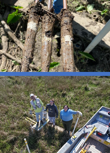
Delta-X: Feldspar Sediment Accretion Measurements, MRD, LA, USA, 2019-2023, Version 4
National Aeronautics and Space Administration —
This dataset provides elevation, hydrogeomorphic zone classification, soil carbon content, bulk density, organic matter content, and sediment accretion measurements... -
Federal
DSCOVR EPIC Level 2 Sulfur dioxide (SO2) Product with EPIC Version 3 Input Version 2
National Aeronautics and Space Administration —
DSCOVR_EPIC_L2_SO2_v03 is the Deep Space Climate Observatory (DSCOVR) Enhanced Polychromatic Imaging Camera (EPIC) Level 2 Sulfur Dioxide (SO2) product with EPIC... -
Federal
CERES and GEO-Enhanced TOA, Within-Atmosphere and Surface Fluxes, Clouds and Aerosols Monthly Terra-Aqua Edition4A
National Aeronautics and Space Administration —
CER_SYN1deg-Month_Terra-Aqua-MODIS_Edition4A is the Clouds and the Earth's Radiant Energy System (CERES) and geostationary (GEO)-Enhanced Top of Atmosphere (TOA),...

Official websites use .gov
A
.gov website belongs to an official government
organization in the United States.
Secure .gov websites use HTTPS
A
lock (
) or https:// means you’ve safely connected to
the .gov website. Share sensitive information only on official,
secure websites.