
-
Federal
ABoVE: Passive Microwave-derived Annual Snowpack Main Melt Onset Date Maps, 1988-2023
National Aeronautics and Space Administration —
This dataset provides the annual date of snowpack seasonal beginning melt (i.e., main melt onset date, MMOD) across northwest Canada, Alaska, US, and parts of far... -
Federal
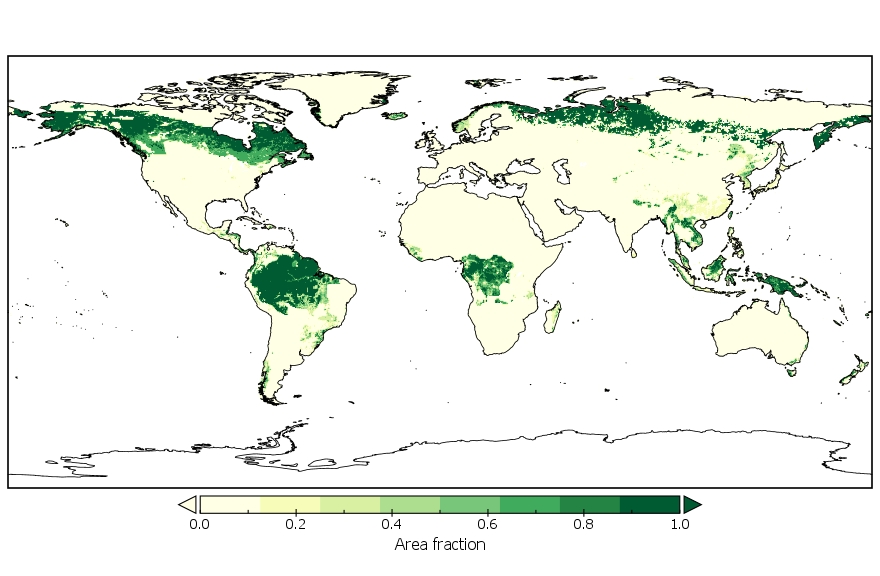
LUH1: Harmonized Global Land Use for Years 1500-2100, V1
National Aeronautics and Space Administration —
These data represent fractional land use and land cover patterns annually for the years 1500 - 2100 for the globe at 0.5-degree (~50-km) spatial resolution. Land use... -
Federal
Tree Canopy Cover for the Circumpolar Taiga-Tundra Ecotone: 2000-2005
National Aeronautics and Space Administration —
This data set provides a map of selected areas with defined tree canopy cover over the circumpolar taiga-tundra ecotone (TTE). Canopy cover was derived from the... -
Federal
NARSTO PAC2001 Langley Site Gaseous, Particle, and Meteorological Data
National Aeronautics and Space Administration —
NARSTO_PAC2001_LANGLEY_GAS_PM_MET_DATA was obtained between August 8 and September 2, 2001 during the Pacific 2001 Air Quality Study (PAC2001).The Langley Ecole... -
Federal
LBA-ECO ND-01 Primary Forests Land Cover Transition Maps, Rondonia, Brazil: 1975-1999
National Aeronautics and Space Administration —
This data set provides classified land cover transition images (maps) derived from Landsat Thematic Mapper (TM) and Multispectral Scanner (MSS) imagery for Ariquemes,... -
Federal
LBA Regional Tree Cover from AVHRR, 1-km, 1992-1993 (DeFries et al.)
National Aeronautics and Space Administration —
The data set consists of a subset for the study area of the Large Scale Biosphere-Atmosphere Experiment in Amazonia (LBA) in South America (i.e., longitude 85 deg to... -
Federal
LUH2-GCB2019: Land-Use Harmonization 2 Update for the Global Carbon Budget, 850-2019
National Aeronautics and Space Administration —
This dataset, referred to as LUH2-GCB2019, includes 0.25-degree gridded, global maps of fractional land-use states, transitions, and management practices for the... -
Federal
SAFARI 2000 Tree Cover from AVHRR, 1-km, 1992-1993 (DeFries et al.)
National Aeronautics and Space Administration —
The data set consists of a southern Africa subset of the 1km Global Tree Cover Data Set developed at the Laboratory for Global Remote Sensing Studies (LGRSS) at the... -
Federal
PROVE Surface albedo of Jornada Experimental Range, New Mexico, 1997
National Aeronautics and Space Administration —
The objective of this study was to determine the spatial variations in field measurements of broadband albedo as related to the ground cover and under a range of... -
Federal
Fluxnet: Archived Website Including Site and Investigator Information
National Aeronautics and Space Administration —
This dataset contains an archived copy of the fluxnet.ornl.gov website as of September 2017. This archived website is provided for informational purposes only. The... -
Federal
LBA-ECO LC-09 Land Cover Transitions Maps for Study Sites in Para, Brazil: 1970-2001
National Aeronautics and Space Administration —
This data set includes classified land cover transition maps at 30-m resolution derived from Landsat TM, MSS, ETM+ imagery and aerial photos of Altamira, Santarem,... -
Federal
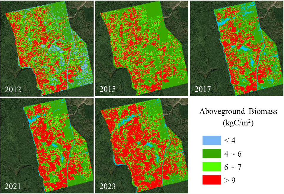
LBA-ECO LC-15 Amazon Basin Aboveground Live Biomass Distribution Map: 1990-2000
National Aeronautics and Space Administration —
The amount and spatial distribution of forest biomass in the Amazon basin is a major source of uncertainty in estimating the flux of carbon released from land-cover... -
Federal
LBA-ECO LC-19 Soil and Vegetation Data for Cerrado and Forested Sites, Brazil: 2002
National Aeronautics and Space Administration —
This data set provides measurements for soil physical and chemical properties, rooting depth and weight, leaf area index (LAI), plant area index (PAI), biomass,... -
Federal
LUH2-ISIMIP2b Harmonized Global Land Use for the Years 2015-2100
National Aeronautics and Space Administration —
This dataset provides 0.25-degree gridded, global, annual estimates of fractional land use and land cover patterns for the period 2015-2100, designed to support the... -
Federal
NARSTO SOS99NASH Wind Profiler Data
National Aeronautics and Space Administration —
The NARSTO_SOS99NASH_WIND_PROFILER_DATA were obtained between May 19 and August 4, 1999. Wind components (u and v) were collected from five 915-MHz radar wind... -
Federal
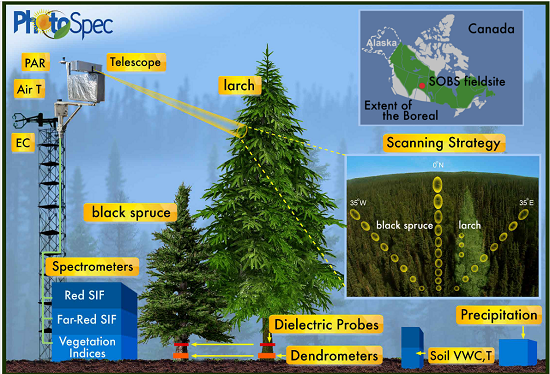
Tower-based PhotoSpec Products for the 2019 and 2020 Spring Transition Season, SK, CA
National Aeronautics and Space Administration —
This dataset includes daily averaged solar-induced chlorophyll fluorescence (SIF) in the red (680-686 nm) and far-red (745-758 nm) wavelength ranges, relative SIF... -
Federal
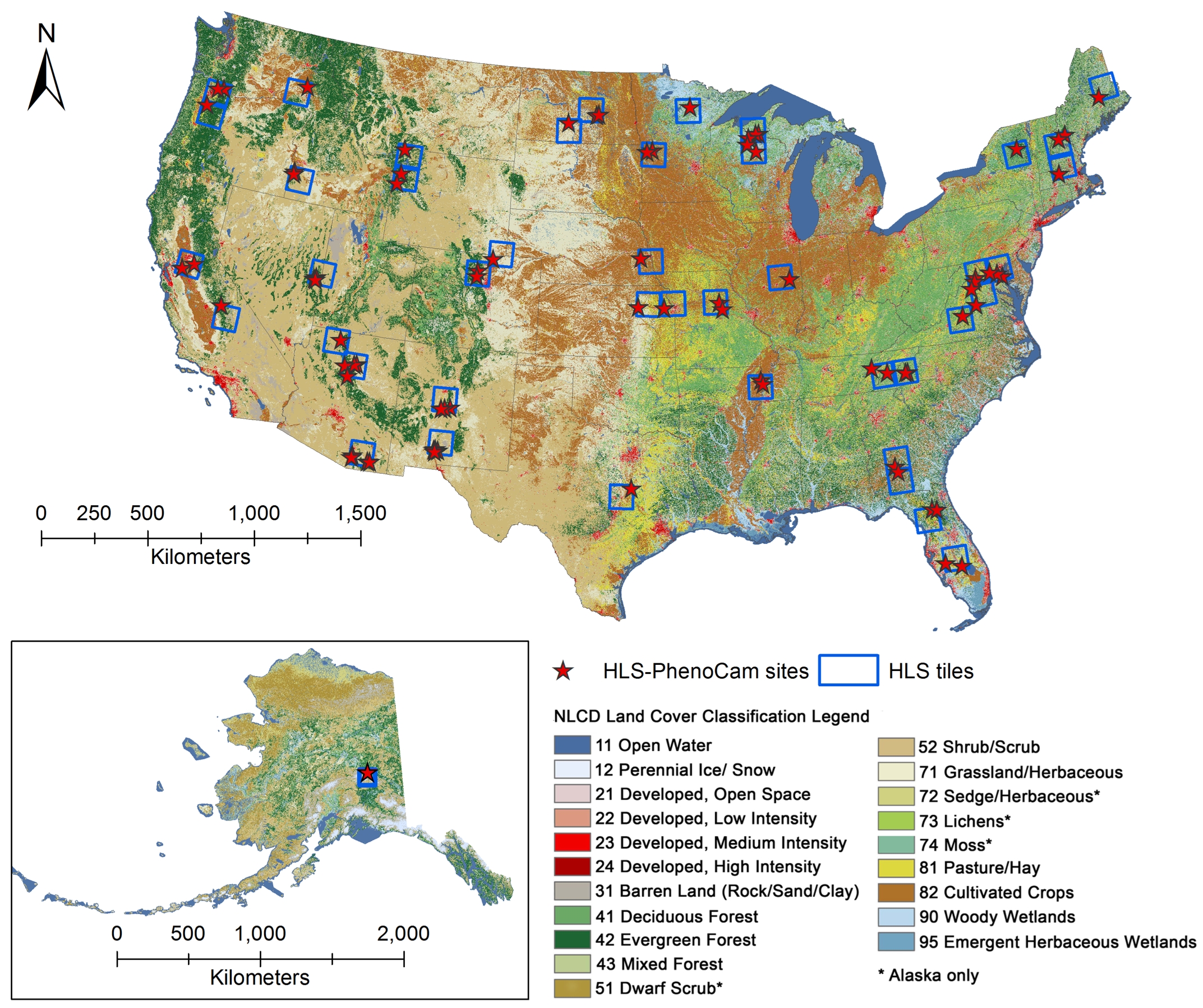
Phenology derived from Satellite Data and PhenoCam across CONUS and Alaska, 2019-2020
National Aeronautics and Space Administration —
This dataset provides a reference of land surface phenology (LSP) at 30-m pixels for 78 regions of 10 x 10 km2 across a wide range of ecological and climatic regions...

Official websites use .gov
A
.gov website belongs to an official government
organization in the United States.
Secure .gov websites use HTTPS
A
lock (
) or https:// means you’ve safely connected to
the .gov website. Share sensitive information only on official,
secure websites.