
-
Federal
LUH1: Harmonized Global Land Use for Years 1500-2100, V1
National Aeronautics and Space Administration —
These data represent fractional land use and land cover patterns annually for the years 1500 - 2100 for the globe at 0.5-degree (~50-km) spatial resolution. Land use... -
Federal
LBA-ECO LC-09 Land Cover Transitions Maps for Study Sites in Para, Brazil: 1970-2001
National Aeronautics and Space Administration —
This data set includes classified land cover transition maps at 30-m resolution derived from Landsat TM, MSS, ETM+ imagery and aerial photos of Altamira, Santarem,... -
Federal
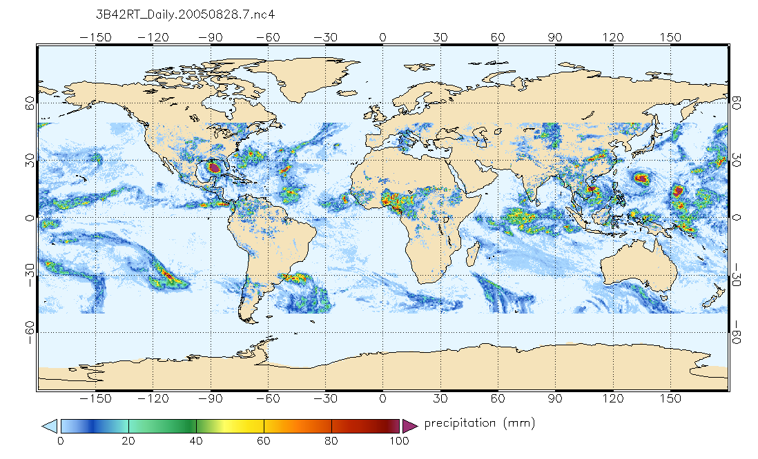
TRMM (TMPA-RT) Near Real-Time Precipitation L3 1 day 0.25 degree x 0.25 degree V7 (TRMM_3B42RT_Daily) at GES DISC
National Aeronautics and Space Administration —
TMPA (3B42RT_Daily) dataset have been discontinued as of Dec. 31, 2019, and users are strongly encouraged to shift to the successor IMERG dataset (doi:... -
Federal
LBA Regional Tree Cover from AVHRR, 1-km, 1992-1993 (DeFries et al.)
National Aeronautics and Space Administration —
The data set consists of a subset for the study area of the Large Scale Biosphere-Atmosphere Experiment in Amazonia (LBA) in South America (i.e., longitude 85 deg to... -
Federal
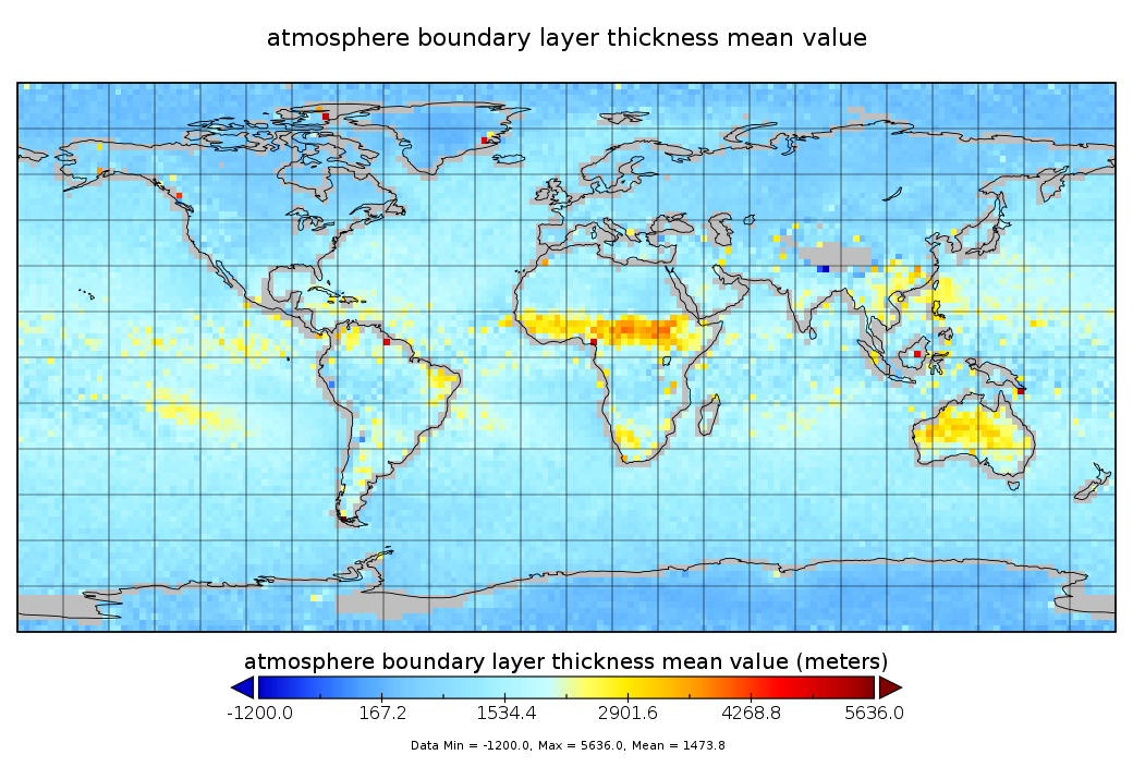
GPS Radio Occultation Boundary Layer Depth Seasonal L3 V2 (GPSROZPBLS) at GES DISC
National Aeronautics and Space Administration —
This dataset provides a seasonal average climatology of global planetary boundary layer (PBL) height derived from COSMIC/FORMOSAT-3, TerraSAR-X, KOMPSAT-5, and PAZ... -
Federal
BOREAS RSS-14 GOES-7 Level-1a Visible, Infrared, and Water Vapor Images
National Aeronautics and Space Administration —
The level-1a BOREAS GOES-7 image data was collected by Remote Sensing Science Team 14 (RSS-14) personnel at the Florida State University and processed to level-1a... -
Federal
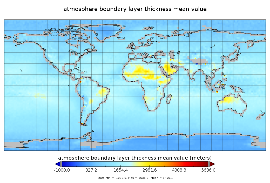
GPS Radio Occultation Boundary Layer Depth Annual L3 V2 (GPSROZPBLA) at GES DISC
National Aeronautics and Space Administration —
This dataset provides an annual average climatology of planetary boundary layer (PBL) height derived from COSMIC/FORMOSAT-3, TerraSAR-X, KOMPSAT-5, and PAZ Global... -
Federal
TRMM (TMPA-RT) Near Real-Time Microwave precipitation estimate L3 3 hour 0.25 degree x 0.25 degree V7 (TRMM_3B40RT) at GES DISC
National Aeronautics and Space Administration —
TMPA (3B40RT) dataset have been discontinued as of Dec. 31, 2019, and users are strongly encouraged to shift to the successor IMERG datasets (doi:... -
Federal
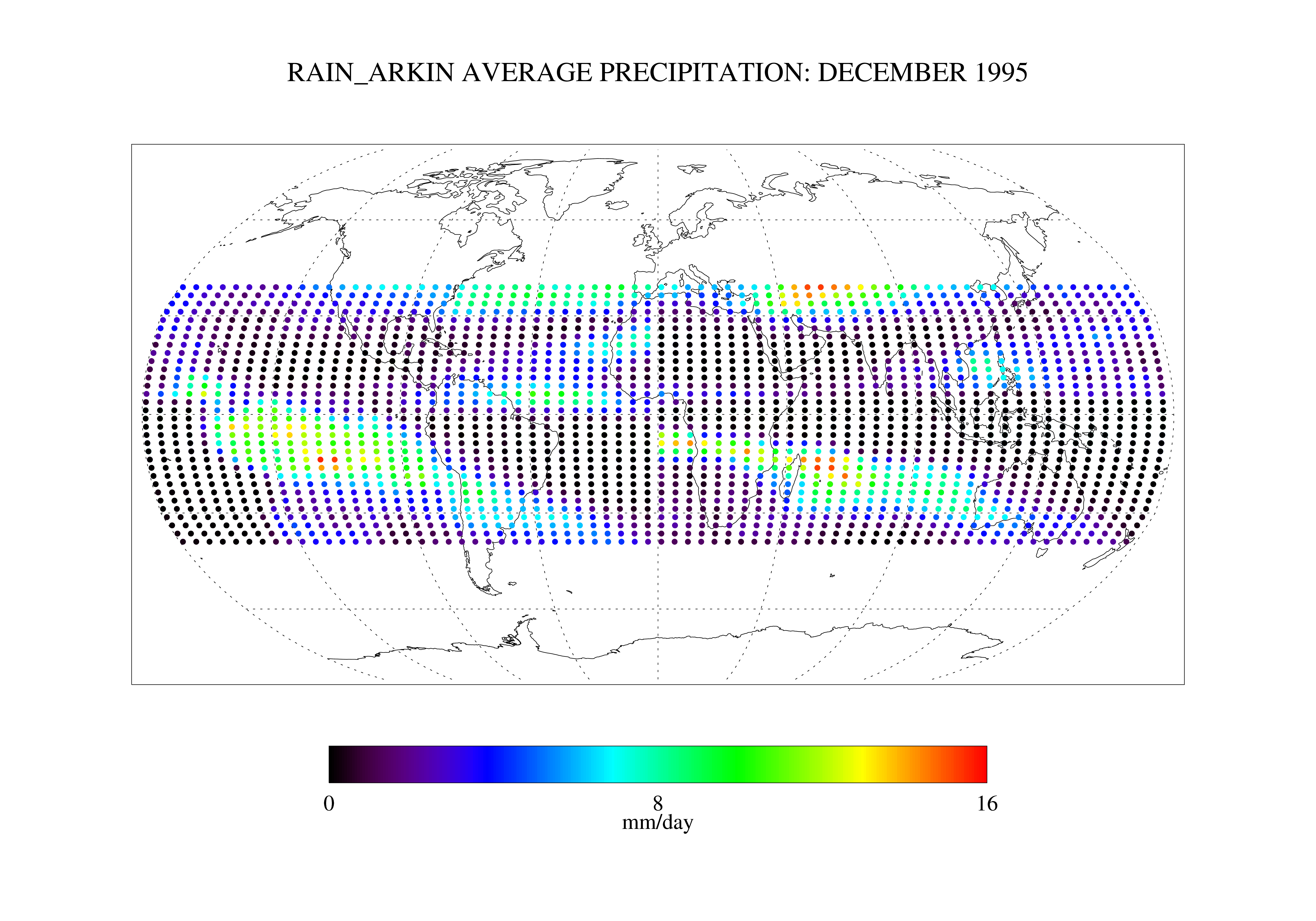
Arkin and Janowiak GPI: IR -Based Monthly Rainfall for the GPCP 2.5 x 2.5 degree V1 (RAIN_ARKIN) at GES DISC
National Aeronautics and Space Administration —
These data are transitioned to a state of permanent preservation. They are available upon request. More advanced datasets have been developed since. One recommended... -
Federal
GPM DPR Ka-band Received Power L1B 1.5 hours 5 km V07 (GPM_PRL1KA) at GES DISC
National Aeronautics and Space Administration —
Version 07 is the current version of the data set. Older versions are no longer available and have been superseded by Version 07. This product contains the calibrated... -
Federal
LBA-ECO ND-01 Primary Forests Land Cover Transition Maps, Rondonia, Brazil: 1975-1999
National Aeronautics and Space Administration —
This data set provides classified land cover transition images (maps) derived from Landsat Thematic Mapper (TM) and Multispectral Scanner (MSS) imagery for Ariquemes,... -
Federal
CALIPSO Wide Field Camera Level 1B 1 km Native Science data, Validated Stage 1 V3-02
National Aeronautics and Space Administration —
CAL_WFC_L1_1Km-ValStage1-V3-02 data are Cloud-Aerosol Lidar and Infrared Pathfinder Satellite Observation (CALIPSO) Wide Field Camera (WFC), Level 1B 1 km Native... -
Federal
GPS Radio Occultation Boundary Layer Depth Seasonal L3 V1 (GPSROZPBLS) at GES DISC
National Aeronautics and Space Administration —
This dataset has been superseded by version 2. It provides seasonal averages of a global planetary boundary layer (PBL) height climatology derived from the... -
Federal
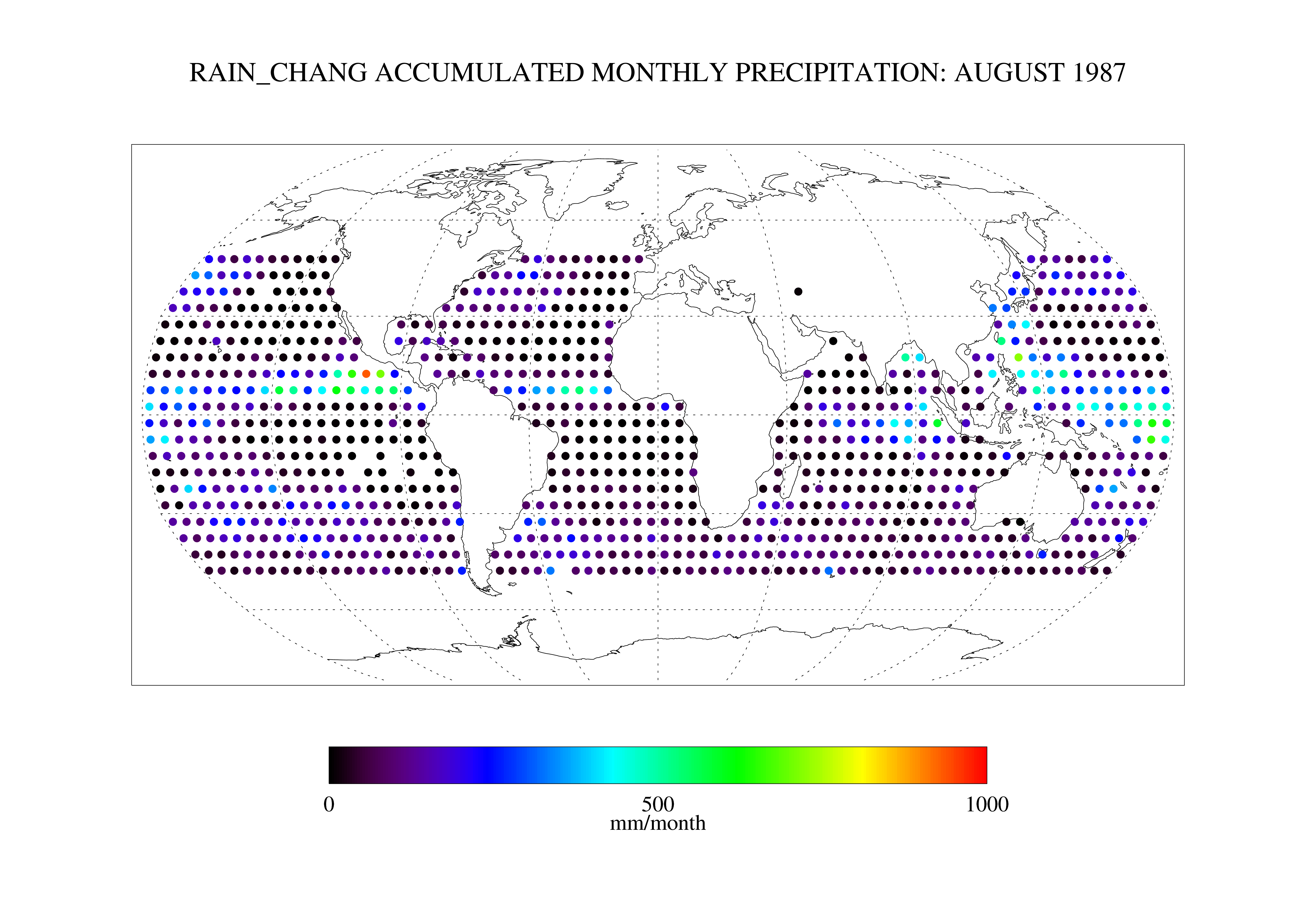
Chang SSM/I Derived Monthly Rain Indices 5 x 5 degree V2.3 (RAIN_CHANG) at GES DISC
National Aeronautics and Space Administration —
These data are transitioned to a state of permanent preservation. They are available upon request. More advanced datasets have been developed since. One recommended... -
Federal
SAFARI 2000 Tree Cover from AVHRR, 1-km, 1992-1993 (DeFries et al.)
National Aeronautics and Space Administration —
The data set consists of a southern Africa subset of the 1km Global Tree Cover Data Set developed at the Laboratory for Global Remote Sensing Studies (LGRSS) at the... -
Federal
PhenoCam Dataset v2.0: Digital Camera Imagery from the PhenoCam Network, 2000-2018
National Aeronautics and Space Administration —
This dataset provides a time series of visible-wavelength digital camera imagery collected through the PhenoCam Network at each of 393 sites predominantly in North... -
Federal
BOREAS RSS-17 1994 ERS-1 Level-3 Freeze/Thaw Backscatter Change Images
National Aeronautics and Space Administration —
The BOREAS RSS-17 team acquired and analyzed imaging radar data from the ESA's ERS-1 over a complete annual cycle at the BOREAS sites in Canada in 1994 to detect... -
Federal
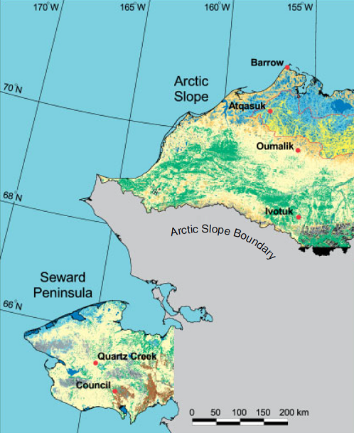
Arctic Vegetation Plots ATLAS Project North Slope and Seward Peninsula, AK, 1998-2000
National Aeronautics and Space Administration —
This data set provides environmental, soil, and vegetation data collected from study sites on the North Slope and Seward Peninsula of Alaska during the Arctic... -
Federal
Fluxnet: Archived Website Including Site and Investigator Information
National Aeronautics and Space Administration —
This dataset contains an archived copy of the fluxnet.ornl.gov website as of September 2017. This archived website is provided for informational purposes only. The...

Official websites use .gov
A
.gov website belongs to an official government
organization in the United States.
Secure .gov websites use HTTPS
A
lock (
) or https:// means you’ve safely connected to
the .gov website. Share sensitive information only on official,
secure websites.