
-
Federal
ASTER Global Digital Elevation Model V003
National Aeronautics and Space Administration —
The Terra Advanced Spaceborne Thermal Emission and Reflection Radiometer (ASTER) Global Digital Elevation Model (GDEM) Version 3 (ASTGTM) provides a global digital... -
Federal
ASTER Digital Elevation Model V004
National Aeronautics and Space Administration —
The Terra Advanced Spaceborne Thermal Emission and Reflection Radiometer (ASTER) Digital Elevation Model (AST14DEM) product is generated using bands 3N (nadir-... -
Federal
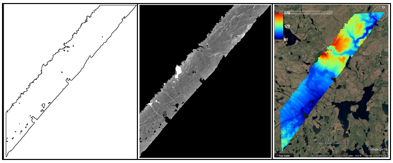
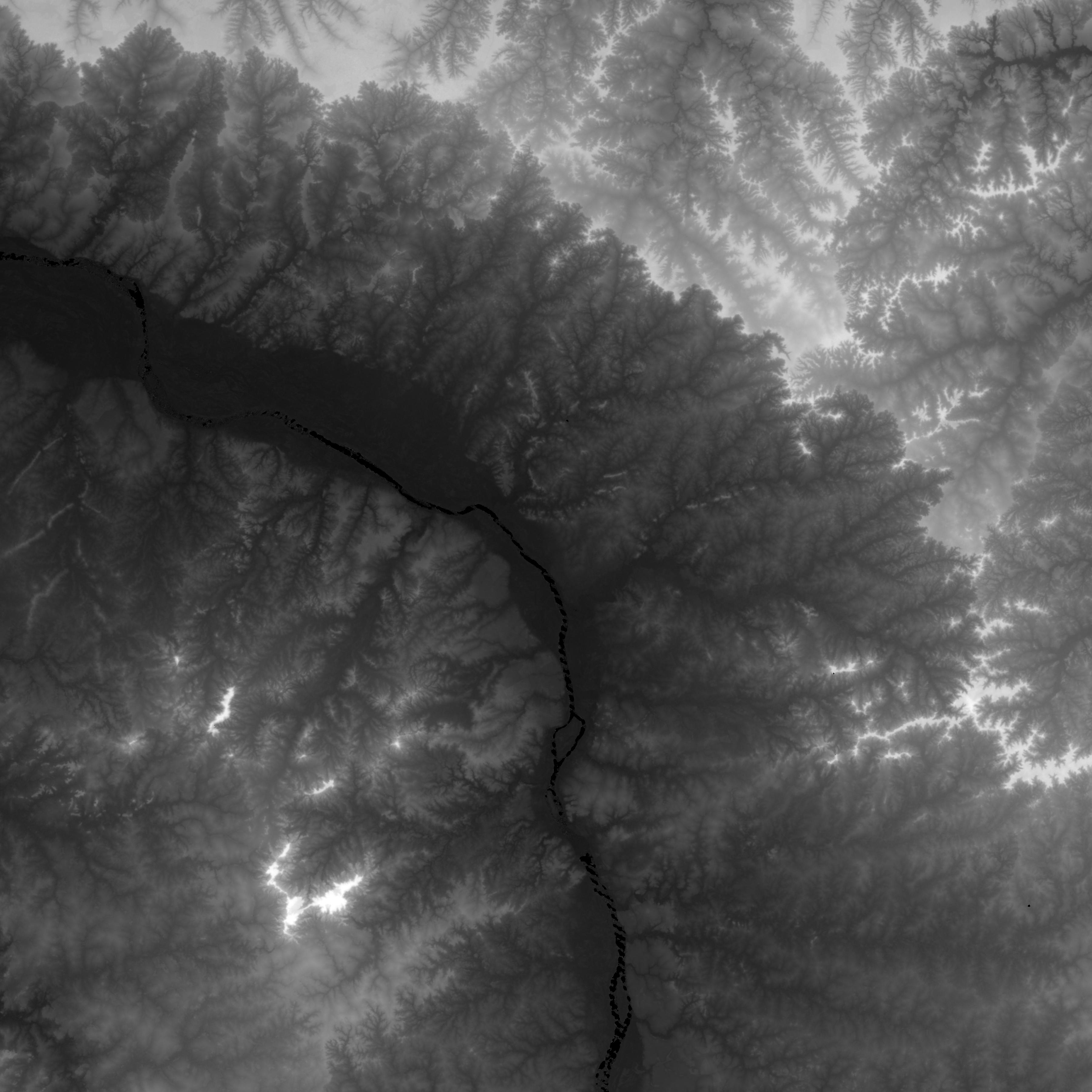
NASA Shuttle Radar Topography Mission Swath Image Data V003
National Aeronautics and Space Administration —
The Land Processes Distributed Active Archive Center (LP DAAC) is responsible for the archive and distribution of NASA Making Earth System Data Records for Use in... -
Federal
ASTER Global Digital Elevation Model NetCDF V003
National Aeronautics and Space Administration —
The Terra Advanced Spaceborne Thermal Emission and Reflection Radiometer (ASTER) Global Digital Elevation Model (GDEM) Version 3 (ASTGTM) provides a global digital... -
Federal
Gazetteer of Planetary Nomenclature: Moon: 1:10 million-scale Shaded Relief and Color-coded Topography: South Pole
National Aeronautics and Space Administration —
These lunar maps display the four different areas of the moon with color-coded topography in low and high resolution approved by the International Astronomical Union... -
Federal
ASTER Digital Elevation Model V003
National Aeronautics and Space Administration —
The Terra Advanced Spaceborne Thermal Emission and Reflection Radiometer (ASTER) Digital Elevation Model (AST14DEM) product is generated using bands 3N (nadir-... -
Federal
ASTER Global Water Bodies Database NetCDF V001
National Aeronautics and Space Administration —
The Terra Advanced Spaceborne Thermal Emission and Reflection Radiometer (ASTER) Global Water Bodies Database (ASTWBD) Version 1 data product provides global coverage... -
Federal
ASTER Global Emissivity Dataset, Monthly, 0.05 deg, HDF5 V041
National Aeronautics and Space Administration —
The Terra Advanced Spaceborne Thermal Emission and Reflection Radiometer (ASTER) Global Emissivity Dataset (GED) is a collection of monthly files (see known issues... -
Federal
ABoVE: AirSWOT Ka-band Radar over Surface Waters of Alaska and Canada, 2017
National Aeronautics and Space Administration —
This dataset provides AirSWOT (Surface Water and Ocean Topography) Ka-band (35.75 GHz) radar data products collected from an airborne platform over parts of Alaska... -
Federal
NASA Shuttle Radar Topography Mission United States 1 arc second number
National Aeronautics and Space Administration —
The SRTMUS1N collection was retired on November 20, 2014, when global SRTM data became available at a resolution of 1 arc second. The data for the United States are... -
Federal
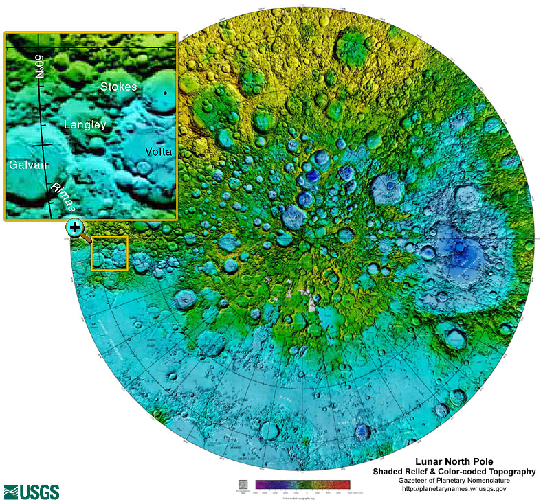
Gazetteer of Planetary Nomenclature: Moon: 1:10 million-scale Shaded Relief and Color-coded Topography: North Pole
National Aeronautics and Space Administration —
These lunar maps display the four different areas of the moon with color-coded topography in low and high resolution approved by the International Astronomical Union... -
Federal
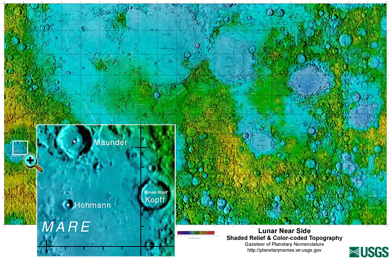
Gazetteer of Planetary Nomenclature: Moon: 1:10 million-scale Shaded Relief and Color-coded Topography: Near Side
National Aeronautics and Space Administration —
These lunar maps display the four different areas of the moon with color-coded topography in low and high resolution approved by the International Astronomical Union... -
Federal
NASADEM SRTM-only Height and Height Precision Mosaic Global 1 arc second V001
National Aeronautics and Space Administration —
The Land Processes Distributed Active Archive Center (LP DAAC) is responsible for the archive and distribution of NASA Making Earth System Data Records for Use in... -
Federal
NASA Shuttle Radar Topography Mission Global 1 arc second Number NetCDF V003
National Aeronautics and Space Administration —
The Land Processes Distributed Active Archive Center (LP DAAC) is responsible for the archive and distribution of the NASA Making Earth System Data Records for Use in... -
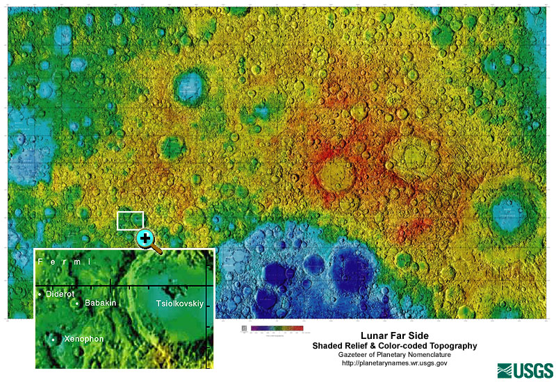
Federal
Gazetteer of Planetary Nomenclature: Moon: 1:10 million-scale Shaded Relief and Color-coded Topography: Far Side
National Aeronautics and Space Administration —
These lunar maps display the four different areas of the moon with color-coded topography in low and high resolution approved by the International Astronomical Union... -
Federal
Gazetteer of Planetary Nomenclature: Mars: Phobos names with images and Deimos
National Aeronautics and Space Administration —
These images display the two moons of Mars: Deimos and Phobos - with HRSC images and shaded relief images with cylindrical and hemispherical views approved by the... -
Federal
LBA-ECO LC-01 Topographic Data for Intensive Study Areas, Northern Ecuadorian Amazon
National Aeronautics and Space Administration —
This data set contains topographic/geomorphological data associated with the four Intensive Study Areas (ISAs) in the Northern Ecuadorian Amazon (northern Oriente)... -
Federal
ASTER Global Water Bodies Database V001
National Aeronautics and Space Administration —
The Terra Advanced Spaceborne Thermal Emission and Reflection Radiometer (ASTER) Global Water Bodies Database (ASTWBD) Version 1 data product provides global coverage... -
Federal
NASA Shuttle Radar Topography Mission Global 3 arc second number V003
National Aeronautics and Space Administration —
The Land Processes Distributed Active Archive Center (LP DAAC) is responsible for the archive and distribution of NASA Making Earth System Data Records for Use in... -
Federal
ASTER Global Emissivity Dataset, Monthly, 0.05 deg, HDF5
National Aeronautics and Space Administration —
The AG5KMMOH Version 4 dataset was decommissioned as of December 14, 2016. Users are encouraged to use Version 4.1 ASTER Global Emissivity Dataset, Monthly, 0.05...

Official websites use .gov
A
.gov website belongs to an official government
organization in the United States.
Secure .gov websites use HTTPS
A
lock (
) or https:// means you’ve safely connected to
the .gov website. Share sensitive information only on official,
secure websites.