
-
Federal
Surface Radiance Data: UNL (FIFE)
National Aeronautics and Space Administration —
The Surface Temperatures, Reflected and Emitted Radiation, and PAR from UNL Data Set contains surface temperatures at different view zenith and azimuth angles, net... -
Federal
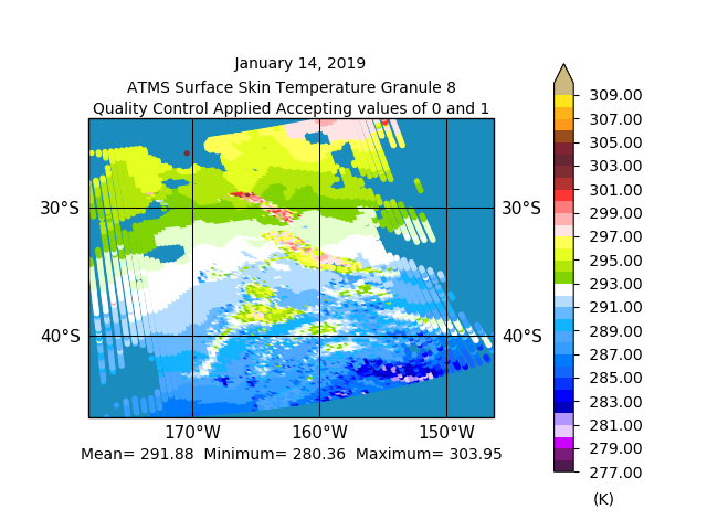
Sounder SIPS: JPSS-1 ATMS Level 2 RAMSES2 Standard: Atmosphere, precipitation and surface geophysical state V3 (SNDRJ1ML2RMS) at GES DISC
National Aeronautics and Space Administration —
This level 2 product is generated by the RAMSES (Retrieval Algorithm for Microwave Sounders in Earth Science II algorithm.The RAMSES II algorithm is a microwave only... -
Federal
ATom: In Situ Atmospheric Water Vapor from the Diode Laser Hygrometer, Version 2
National Aeronautics and Space Administration —
This dataset provides the concentrations of water measured by the Diode Laser Hygrometer (DLH) flown on the NASA DC-8 during the ATom 1-4 campaigns from 2016 - 2018.... -
Federal
MLS/Aura Level 3 Daily Binned Relative Humidity With Respect To Ice (RHI) on Assorted Grids V005 (ML3DBRHI) at GES DISC
National Aeronautics and Space Administration —
ML3DBRHI is the EOS Aura Microwave Limb Sounder (MLS) daily binned on various vertical grids product for relative humidity with respect to ice (RHI) derived from... -
Federal
TROPICS05 L2B Deep Multispectral INtensity (DMIN) of Tropical Cyclones Estimator Algorithm V0.2
National Aeronautics and Space Administration —
The "Time-Resolved Observations of Precipitation structure and storm Intensity with a Constellation of Smallsats" (TROPICS) mission has a goal of providing nearly... -
Federal
TROPICS03 L2B Deep Multispectral INtensity (DMIN) of Tropical cyclones estimator Algorithm V1.0
National Aeronautics and Space Administration —
The "Time-Resolved Observations of Precipitation structure and storm Intensity with a Constellation of Smallsats" (TROPICS) mission has a goal of providing nearly... -
Federal
TROPICS05 L1B Orbital Geolocated Native-Resolution Brightness Temperatures V0.2
National Aeronautics and Space Administration —
The "Time-Resolved Observations of Precipitation structure and storm Intensity with a Constellation of Smallsats" (TROPICS) mission has a goal of providing nearly... -
Federal
SAFARI 2000 Surface Atmospheric Radiative Transfer (SMART), Dry Season 2000
National Aeronautics and Space Administration —
Surface-sensing Measurements for Radiative Transfer (SMART) and Chemical, Optical, and Microphysical Measurements of In-situ Troposphere (COMMIT) consist of a suite... -
Federal
TROPICS01 L2B Deep Multispectral INtensity (DMIN) of Tropical Cyclones Estimator Algorithm V1.0
National Aeronautics and Space Administration —
The "Time-Resolved Observations of Precipitation structure and storm Intensity with a Constellation of Smallsats" (TROPICS) mission has a goal of providing nearly... -
Federal
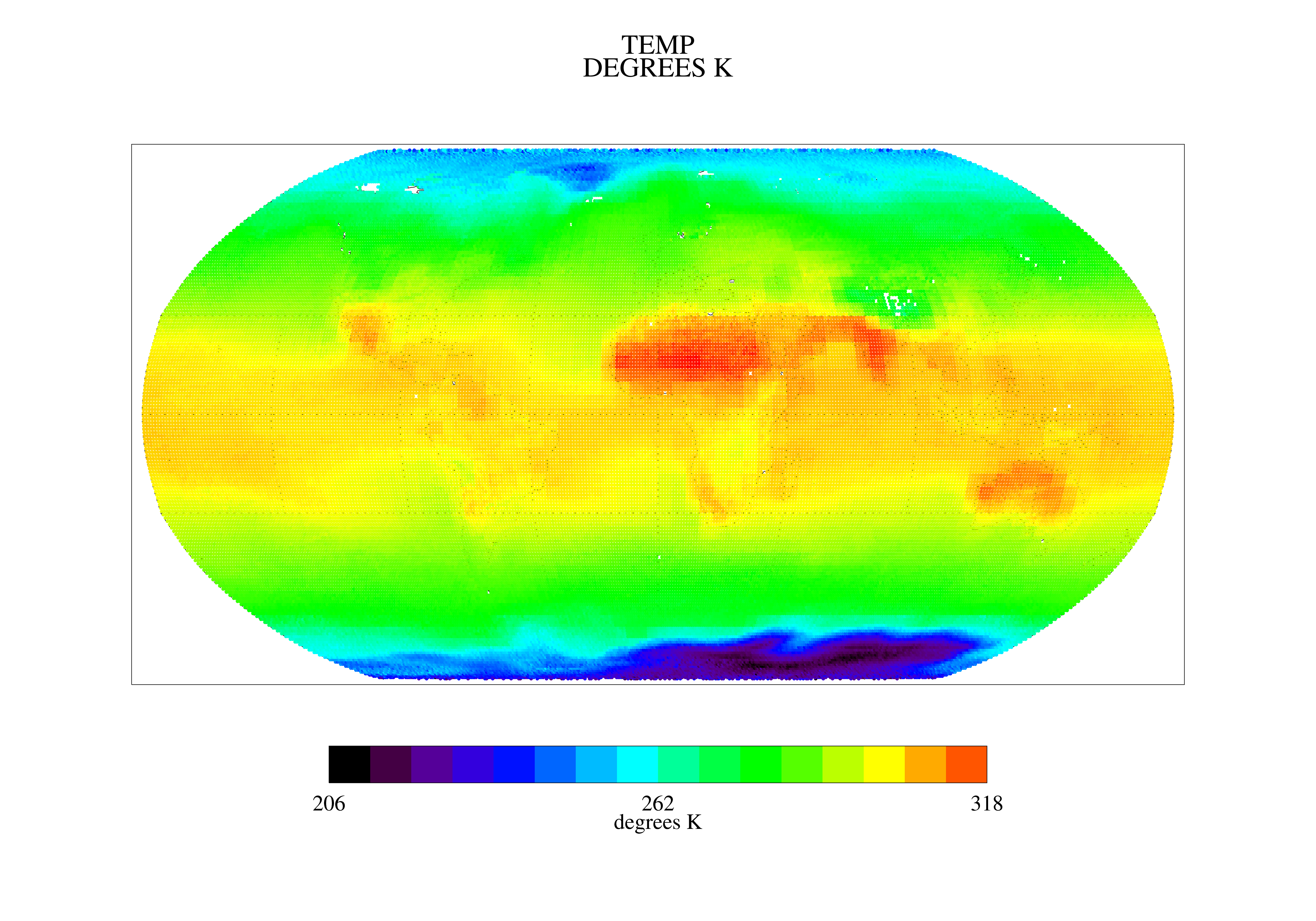
TOVS GLA MONTHLY GRIDS from NOAA-9 V01 (TOVSAMNF) at GES DISC
National Aeronautics and Space Administration —
This dataset (TOVSAMNF) contains the TIROS Operational Vertical Sounder (TOVS) level 3 geophysical parameters derived using data from NOAA-9 and the physical... -
Federal
TROPICS07 L2B Neural-network Atmospheric Vertical Temperature & Moisture Profiles V0.2
National Aeronautics and Space Administration —
The "Time-Resolved Observations of Precipitation structure and storm Intensity with a Constellation of Smallsats" (TROPICS) mission has a goal of providing nearly... -
Federal
Sounder SIPS: AQUA AIRS IR-only Level 2: Atmospheric state at Standard Pressure Levels derived from CLIMCAPS V2.1 (SNDRAQIL2PLEVCPS) at GES DISC
National Aeronautics and Space Administration —
The CLIMCAPS (Community Long-term Infrared Microwave Coupled Product System) algorithm is used to analyze data from the AIRS (Atmospheric Infrared Sounder) instrument... -
Federal
In-situ Air Temperature and Relative Humidity in Greenbelt, MD, 2013-2015
National Aeronautics and Space Administration —
This data set describes the temperature and relative humidity at 12 locations around Goddard Space Flight Center in Greenbelt MD at 15 minute intervals between... -
Federal
MRIR/Nimbus-3 Level 1 Meteorological Radiation Data V001 (MRIRN3L1) at GES DISC
National Aeronautics and Space Administration —
MRIRN3L1 is the Nimbus-3 Medium-Resolution Infrared Radiometer (MRIR) Level 1 Meteorological Radiance Data product and contain radiances expressed as equivalent... -
Federal
TROPICS07 L2B Tropical Cyclone Intensity Estimate (TCIE) Algorithm V1.0
National Aeronautics and Space Administration —
The "Time-Resolved Observations of Precipitation structure and storm Intensity with a Constellation of Smallsats" (TROPICS) mission has a goal of providing nearly... -
Federal
THIR/Nimbus-7 Level 1 Cloud Data for SBUV/TOMS V001 (THIRN7L1BCLT) at GES DISC
National Aeronautics and Space Administration —
THIRN7L1BCLT is the Nimbus-7 Temperature-Humidity Infrared Radiometer (THIR) Level 1 Cloud Data for SBUV/TOMS (BCLT) product and contains total cloud amounts;... -
Federal
TROPICS07 L2B Deep Multispectral INtensity (DMIN) of Tropical Cyclones Estimator Algorithm V0.2
National Aeronautics and Space Administration —
The "Time-Resolved Observations of Precipitation structure and storm Intensity with a Constellation of Smallsats" (TROPICS) mission has a goal of providing nearly... -
Federal
TROPICS03 L2A Unified Resolution Brightness Temperatures V1.0
National Aeronautics and Space Administration —
The "Time-Resolved Observations of Precipitation structure and storm Intensity with a Constellation of Smallsats" (TROPICS) mission has a goal of providing nearly... -
Federal
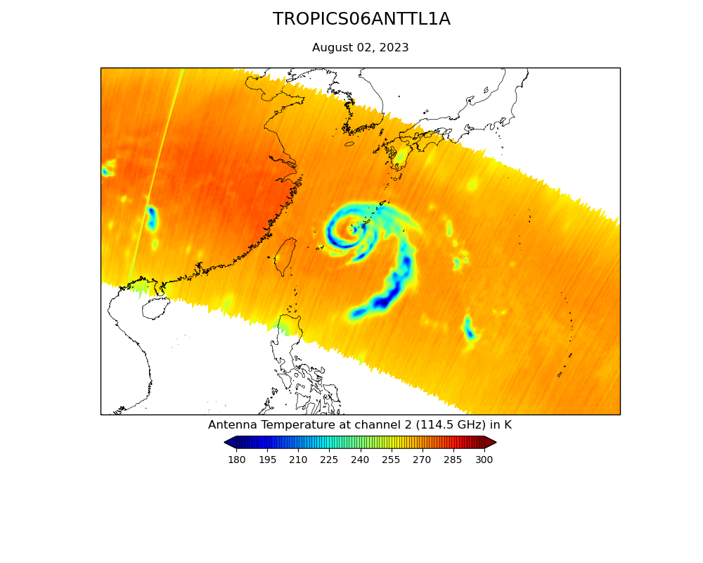
TROPICS07 L1A Orbital Geolocated Native-Resolution Antenna Temperatures V0.2
National Aeronautics and Space Administration —
The "Time-Resolved Observations of Precipitation structure and storm Intensity with a Constellation of Smallsats" (TROPICS) mission has a goal of providing nearly... -
Federal
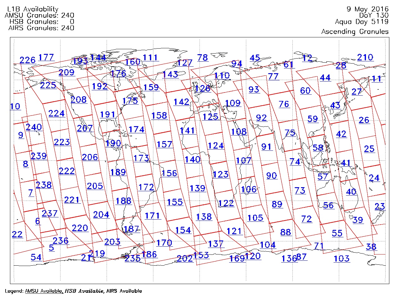
AIRS/Aqua Granule map product V005 (AIRXAMAP) at GES DISC
National Aeronautics and Space Administration —
The Atmospheric Infrared Sounder (AIRS) is a grating spectrometer (R = 1200) aboard the second Earth Observing System (EOS) polar-orbiting platform, EOS Aqua. In...

Official websites use .gov
A
.gov website belongs to an official government
organization in the United States.
Secure .gov websites use HTTPS
A
lock (
) or https:// means you’ve safely connected to
the .gov website. Share sensitive information only on official,
secure websites.