
-
Federal
AMSR-E L2 Rainfall Subset, collocated with CloudSat track V002 (AMSERR_CPR) at GES DISC
National Aeronautics and Space Administration —
This is a subset of AMSR-E rain rate product along CloudSat field of view track. The goal of the subset is to select and return AMSR-E data that are within -100 km... -
Federal
AIDJEX Beaufort Sea Upward Looking Sonar April 1976, Version 1
National Aeronautics and Space Administration —
This data contains Upward Looking Sonar (ULS) profiles of the underside of the Arctic pack ice along three transects whose total length is 777 nautical miles. The... -
Federal
SHIFT: Laboratory Foliar Chemical Analysis Results for Field Samples, CA, 2022
National Aeronautics and Space Administration —
This dataset holds laboratory foliar chemical analyses results for field samples collected during the 2022 NASA Surface Biology Geology (SBG) High Frequency Time... -
Federal
Wind SMS Suite SupraThermal Ion Composition Spectrometer (SMS/STICS) Energy-Resolved Pitch-Angle Distributions (ERPAs), Level 2 (L2), 30-minute Data in Solar Wind
National Aeronautics and Space Administration —
The data include Wind STICS 30-minute Energy-Resolved Pitch-Angle Distributions (ERPAs) for selected ion species using triple coincidence (H+, He+, He2+, C5+, O+,... -
Federal
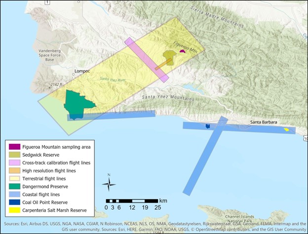
SHIFT: Vegetation Plot Characterization, Santa Barbara County, CA, 2022
National Aeronautics and Space Administration —
This dataset contains vegetation plot locations, descriptions, fractional cover, and sample identifier information from surveys conducted as part of the 2022 NASA... -
Federal
SHIFT: Vegetation Plot Photos, Santa Barbara, CA, USA, 2022
National Aeronautics and Space Administration —
This dataset contains photographs of the plots where field vegetation sampling was conducted during the 2022 NASA Surface Biology Geology (SBG) High Frequency Time... -
Federal
Wind SMS Suite SupraThermal Ion Composition Spectrometer (SMS/STICS) Energy-Resolved Pitch-Angle Distributions (ERPAs), Level 2 (L2), 30-minute Data in Magnetosphere
National Aeronautics and Space Administration —
The data include Wind STICS 30-minute Energy-Resolved Pitch-Angle Distributions (ERPAs) for selected ion species using triple coincidence (H+, He+, He2+, C5+, O+,... -
Federal
Swift Gamma-ray Urgent Archiver for Novel Opportunities (GUANO) Events
National Aeronautics and Space Administration —
The Swift Observatory provides event-level data from the Burst Alert Telescope (BAT) on demand in response to transients detected by other observatories/instruments.... -
Federal
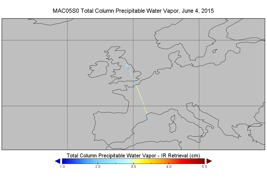
MODIS/Aqua Total Precip Water Vapor 1km and 5km 5-Min L2 Narrow Swath Subset along CloudSat V002 (MAC05S0) at GES DISC NGDA
National Aeronautics and Space Administration —
This is the narrow-swath MODIS/Aqua subset along CloudSat field of view track. The goal of the narrow-swath subset is to select and return MODIS data that are within... -
Federal
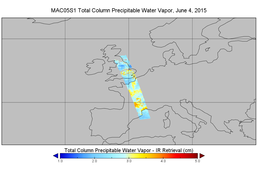
MODIS/Aqua Total Precip Water Vapor 1km and 5km 5-Min L2 Wide Swath Subset along CloudSat V002 (MAC05S1) at GES DISC NGDA
National Aeronautics and Space Administration —
This is the wide-swath MODIS/Aqua subset along CloudSat field of view track. The goal of the wide-swath subset is to select and return MODIS data that are within... -
Federal
MODIS/Aqua Total Precip Water Vapor 1km and 5km 5-Min L2 Swath Subset along MLS V002 (MAM05S0) at GES DISC NGDA
National Aeronautics and Space Administration —
This is the MODIS/Aqua subset along MLS field of view track. The goal of the subset is to select and return MODIS data that are within +-100 km across the MLS track.... -
Federal
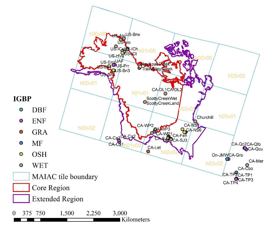
ABoVE: Corrected MODIS MAIAC Reflectance at Tower Sites, Alaska and Canada, 2000-2016
National Aeronautics and Space Administration —
This dataset provides angular corrections of MODIS Multi-Angle Implementation of Atmospheric Correction algorithm (MAIAC) surface reflectances by two methods at each... -
Federal
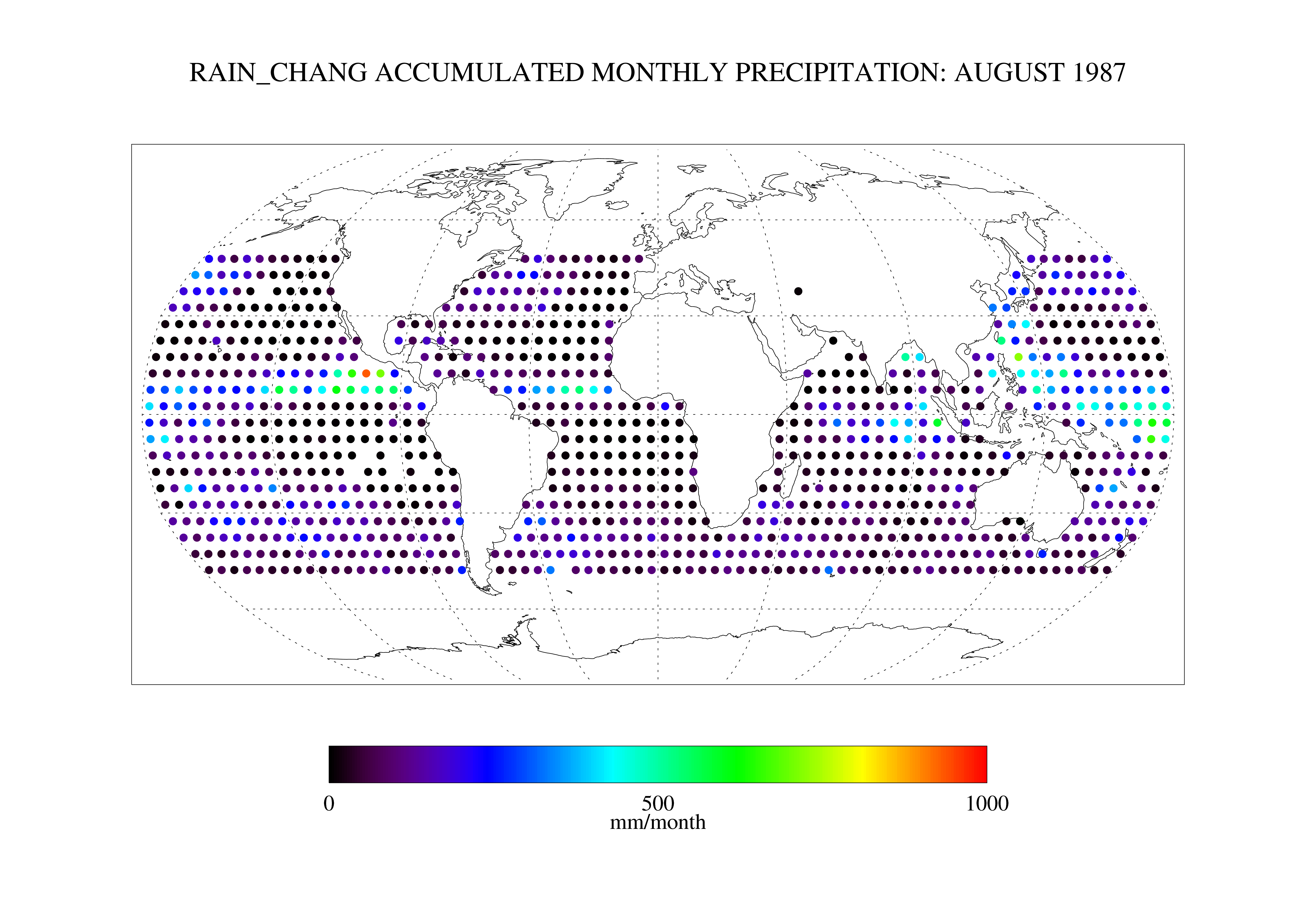
Chang SSM/I Derived Monthly Rain Indices 5 x 5 degree V2.3 (RAIN_CHANG) at GES DISC
National Aeronautics and Space Administration —
These data are transitioned to a state of permanent preservation. They are available upon request. More advanced datasets have been developed since. One recommended... -
Federal
ABoVE: Dall Sheep Response to Snow and Landscape Covariates, Alaska, 2005-2008
National Aeronautics and Space Administration —
This dataset provides daily estimates of snow depth and snow density for the study area in Lake Clark National Park and Preserve (LCNPP), Alaska. The data were... -
Federal
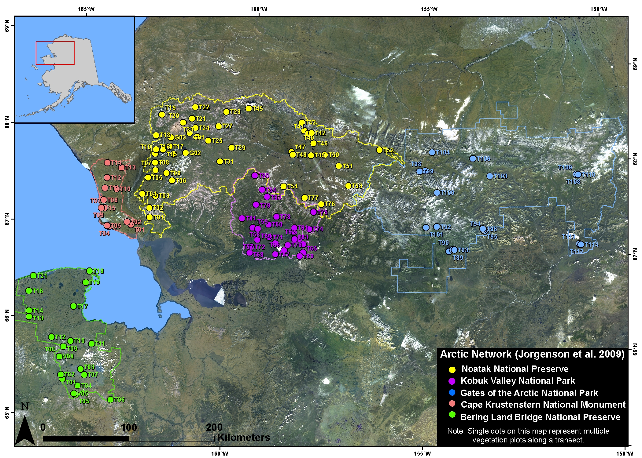
Arctic Vegetation Plots in NPS Arctic Network Parks, Alaska, 2002-2008
National Aeronautics and Space Administration —
This dataset provides environmental, soil, and vegetation data collected at selected locations in the parks and preserves of the National Park Service (NPS) Arctic... -
Federal
Measurements along the Big Bend Wildlife Preservation area, Florida
National Aeronautics and Space Administration —
Measurements made along the Big Bend Wildlife Preservation area of the Florida Gulf Coast in 2010 and 2011. -
Federal
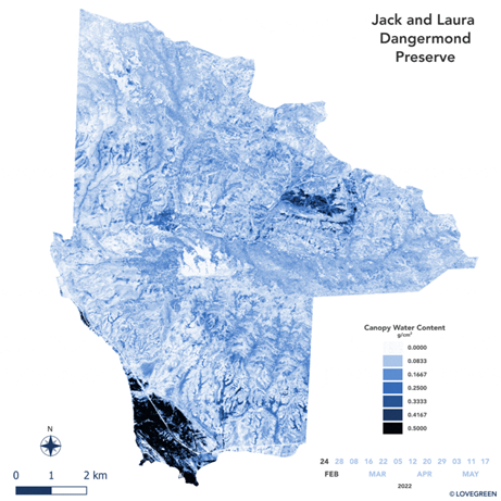
SHIFT: AVIRIS-NG Derived Gridded Mosaicked Canopy Water Content, California, 2022
National Aeronautics and Space Administration —
This dataset provides per-pixel vegetation canopy water content (CWC) derived from surface reflectance measured by the Airborne Visible/Infrared Imaging Spectrometer-... -
Federal
ROSAT PSPC 400 Square Degree Galaxy Cluster Catalog
National Aeronautics and Space Administration —
This is a catalog of galaxy clusters detected in a new ROSAT PSPC survey. The survey is optimized to sample, at high redshifts, the mass range corresponding to T >... -
Federal
SHIFT: Photosynthetic and Leaf Traits, Santa Barbara County, 2022
National Aeronautics and Space Administration —
This dataset provides leaf images and measurements of leaf traits (area, wet weight, dry weight, leaf mass per area, leaf water content) and leaf pigments...

Official websites use .gov
A
.gov website belongs to an official government
organization in the United States.
Secure .gov websites use HTTPS
A
lock (
) or https:// means you’ve safely connected to
the .gov website. Share sensitive information only on official,
secure websites.