
-
Federal
Combined ASTER and MODIS Emissivity database over Land (CAMEL) Emissivity Monthly Global 0.05Deg V001
National Aeronautics and Space Administration —
The CAM5K30EM.001 dataset was decommissioned as of March 14, 2019. Users are encouraged to use the new improved CAM5K30EM.003 dataset.The NASA Making Earth System... -
Federal
Global Rural-Urban Mapping Project, Version 1 (GRUMPv1): Urban Extent Polygons, Revision 02
National Aeronautics and Space Administration —
The Global Rural-Urban Mapping Project, Version 1 (GRUMPv1): Urban Extent Polygons, Revision 02 is an update to Revision 01, which included new settlements and... -
Federal
Global Urban Polygons and Points Dataset (GUPPD), Version 1
National Aeronautics and Space Administration —
The Global Urban Polygons and Points Dataset (GUPPD), Version 1 is a global data set of 123,034 urban settlements with place names and population for the years... -
Federal
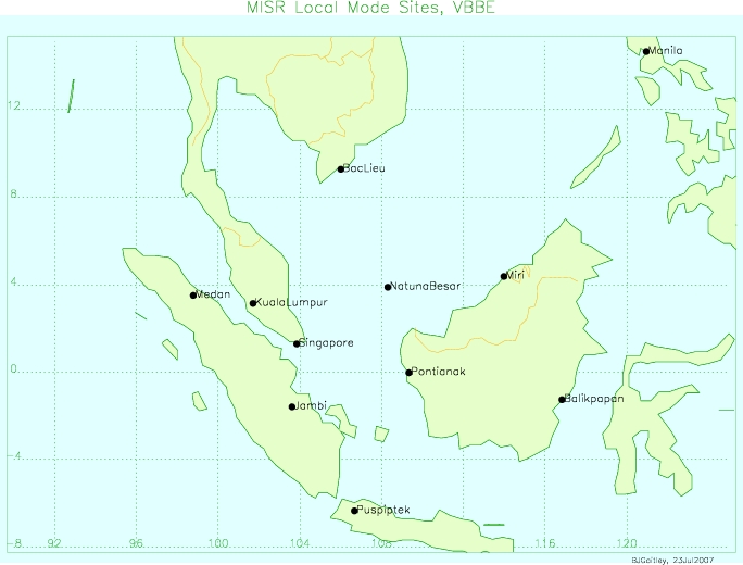
MISR Level 2 Land Surface Product subset for the VBBE region V002
National Aeronautics and Space Administration —
VBEMI2LS_002 is the Multi-angle Imaging SpectroRadiometer (MISR) Level 2 Land Surface Product subset for the VBBE region version 2. It contains information on land... -
Federal
MISR Level 1B2 Ellipsoid Product subset for the VBBE region V003
National Aeronautics and Space Administration —
VBEMIB2E_003 is the Multi-angle Imaging SpectroRadiometer (MISR) Level 1B2 Ellipsoid Product subset for the VBBE region version 3. It contains Ellipsoid-projected TOA... -
Federal
NASADEM Merged DEM Global 1 arc second V001
National Aeronautics and Space Administration —
The Land Processes Distributed Active Archive Center (LP DAAC) is responsible for the archive and distribution of the NASA Making Earth System Data Records for Use in... -
Federal
NASADEM Merged DEM Source Global 1 arc second nc V001
National Aeronautics and Space Administration —
The Land Processes Distributed Active Archive Center (LP DAAC) is responsible for the archive and distribution of the NASA Making Earth System Data Records for Use in... -
Federal
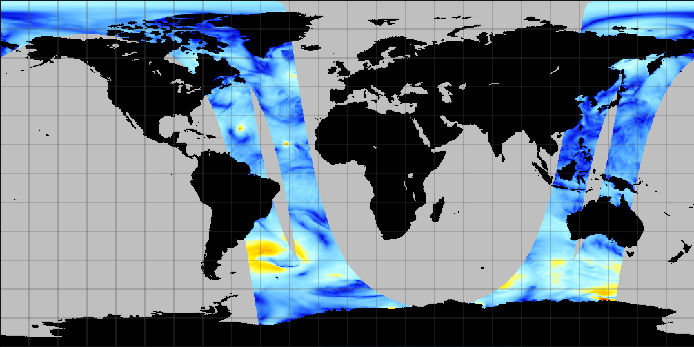
SCATSAT-1 ESDR Level 2 Ancillary Ocean Surface Fields Version 1.1
National Aeronautics and Space Administration —
This dataset contains the first science quality release (post-provisional after v1.0) of the MEaSUREs-funded Earth Science Data Record (ESDR) of ancillary data... -
Federal
Methane Plumes Derived from AVIRIS-NG over Point Sources across California, 2016-2017
National Aeronautics and Space Administration —
This dataset provides maps of methane (CH4) plumes along flight lines over identified methane point-source emitting infrastructure across the State of California, USA... -
Federal
Combined ASTER and MODIS Emissivity database over Land (CAMEL) Emissivity Monthly Global 0.05Deg V002
National Aeronautics and Space Administration —
The NASA Making Earth System Data Records for Use in Research Environments (MEaSUREs) Combined Advanced Spaceborne Thermal Emission and Reflection Radiometer (ASTER)... -
Federal
Combined ASTER and MODIS Emissivity database over Land (CAMEL) Uncertainty Climatology Monthly Global 0.05Deg V003
National Aeronautics and Space Administration —
The NASA Making Earth System Data Records for Use in Research Environments (MEaSUREs) Combined Advanced Spaceborne Thermal Emission and Reflection Radiometer (ASTER)... -
Federal
MISR Level 2 TOA/Cloud Aerosol Product subset for the VBBE region V002
National Aeronautics and Space Administration —
VBEMI2AE_002 is the Multi-angle Imaging SpectroRadiometer (MISR) Level 2 TOA/Cloud Aerosol Product subset for the VBBE region version 2. It contains Aerosol optical... -
Federal
Combined ASTER and MODIS Emissivity database over Land (CAMEL) Emissivity Monthly Global 0.05Deg V003
National Aeronautics and Space Administration —
The NASA Making Earth System Data Records for Use in Research Environments (MEaSUREs) Combined Advanced Spaceborne Thermal Emission and Reflection Radiometer (ASTER)... -
Federal
Combined ASTER and MODIS Emissivity database over Land (CAMEL) Covariances Climatology Monthly Global 0.25Deg V003
National Aeronautics and Space Administration —
The NASA Making Earth System Data Records for Use in Research Environments (MEaSUREs) Combined Advanced Spaceborne Thermal Emission and Reflection Radiometer (ASTER)... -
Federal
MetOp-A ASCAT ESDR Level 2 Ancillary Ocean Surface Fields Version 1.1
National Aeronautics and Space Administration —
This dataset contains model output interpolated in space and time to observations from the MetOp-A ASCAT (ASCAT-A) instrument (a satellite-based scatterometer),... -
Federal
MISR Level 1B2 Terrain Product subset for the VBBE region V003
National Aeronautics and Space Administration —
VBEMIB2T_003 is the Multi-angle Imaging SpectroRadiometer (MISR) Level 1B2 Terrain Product subset for the VBBE region version 3. It contains Terrain-projected TOA... -
Federal
MetOp-B ASCAT ESDR Level 2 Ancillary Ocean Surface Fields Version 1.1
National Aeronautics and Space Administration —
This dataset contains model output interpolated in space and time to observations from the MetOp-B ASCAT (ASCAT-B) instrument (a satellite-based scatterometer),... -
Federal
QuikSCAT ESDR Level 2 Ancillary Ocean Surface Fields Version 1.1
National Aeronautics and Space Administration —
This dataset contains model output interpolated in space and time to the ESDR product from the scatterometer on the QuikSCAT satellite, representing the first science... -
Federal
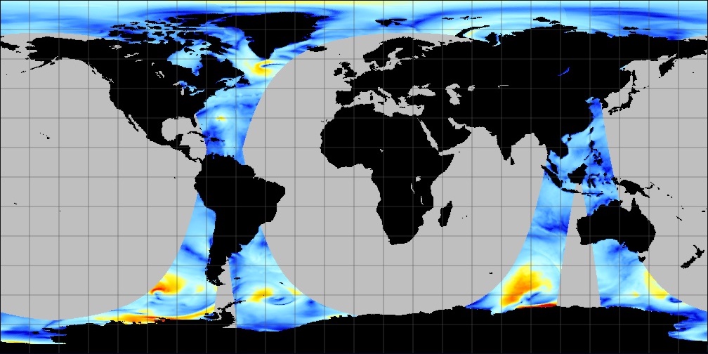
NSCAT Level 3 Daily Gridded Ocean Surface Wind Vector Browse Images (JPL)
National Aeronautics and Space Administration —
This dataset provides browse images of the NASA Scatterometer (NSCAT) Level 3 daily gridded ocean wind vectors, which are provided at 0.5 degree spatial resolution... -
Federal
NASADEM Merged DEM Global 1 arc second nc V001
National Aeronautics and Space Administration —
The Land Processes Distributed Active Archive Center (LP DAAC) is responsible for the archive and distribution of the NASA Making Earth System Data Records for Use in...

Official websites use .gov
A
.gov website belongs to an official government
organization in the United States.
Secure .gov websites use HTTPS
A
lock (
) or https:// means you’ve safely connected to
the .gov website. Share sensitive information only on official,
secure websites.