
-
Federal
Global Landslide Catalog Export
National Aeronautics and Space Administration —
The Global Landslide Catalog (GLC) was developed with the goal of identifying rainfall-triggered landslide events around the world, regardless of size, impacts or... -
Federal
Global Flood Hazard Frequency and Distribution
National Aeronautics and Space Administration —
The Global Flood Hazard Frequency and Distribution is a 2.5 minute grid derived from a global listing of extreme flood events between 1985 and 2003 (poor or missing... -
Federal
NASA Earth Observatory Images
National Aeronautics and Space Administration —
The Earth Observatory is part of the EOS Project Science Office located at NASA Goddard Space Flight Center. -
Federal
Global Landslide Hazard Distribution
National Aeronautics and Space Administration —
The Global Landslide Hazard Distribution is a 2.5 minute grid of global landslide and snow avalanche hazards based upon work of the Norwegian Geotechnical Institute... -
Federal
NASA Disasters Mapping Portal
National Aeronautics and Space Administration —
This entry does not contain data itself, it is for the website, the NASA Disasters Mapping Portal: https://maps.disasters.nasa.gov The Disasters Mapping Portal... -
Federal
FLDAS Noah Land Surface Model L4 Global Monthly 0.1 x 0.1 degree (MERRA-2 and CHIRPS) V001 (FLDAS_NOAH01_C_GL_M) at GES DISC
National Aeronautics and Space Administration —
This dataset contains a series of land surface parameters simulated from the Noah 3.6.1 model in the Famine Early Warning Systems Network (FEWS NET) Land Data... -
Federal
Geocoded Disasters (GDIS) Dataset
National Aeronautics and Space Administration —
The Geocoded Disasters (GDIS) Dataset is a geocoded extension of a selection of natural disasters from the Centre for Research on the Epidemiology of Disasters'... -
Federal
Global Earthquake Proportional Economic Loss Risk Deciles
National Aeronautics and Space Administration —
The Global Earthquake Proportional Economic Loss Risk Deciles is a 2.5 minute grid of earthquake hazard economic loss as proportions of Gross Domestic Product (GDP)... -
Federal
Global Volcano Hazard Frequency and Distribution
National Aeronautics and Space Administration —
Global Volcano Hazard Frequency and Distribution is a 2.5 minute gridded data set based upon the National Geophysical Data Center (NGDC) Volcano Database spanning the... -
Federal
Global Earthquake Hazard Distribution - Peak Ground Acceleration
National Aeronautics and Space Administration —
The Global Earthquake Hazard Distribution - Peak Ground Acceleration is a 2.5 minute grid of global earthquake hazards developed using Global Seismic Hazard Program... -
Federal
Global Landslide Catalog Export
National Aeronautics and Space Administration —
The Global Landslide Catalog (GLC) was developed with the goal of identifying rainfall-triggered landslide events around the world, regardless of size, impacts or... -
Federal
Global Fire Atlas with Characteristics of Individual Fires, 2003-2016
National Aeronautics and Space Administration —
The Global Fire Atlas is a global dataset that tracks the day-to-day dynamics of individual fires to determine the timing and location of ignitions, fire size,... -
Federal
NEOWISE-R Single Exposure (L1b) Source Table
National Aeronautics and Space Administration —
The Near-Earth Object Wide-field Infrared Survey Explorer Reactivation Mission (NEOWISE; Mainzer et al. 2014, ApJ, 792, 30) is a NASA Planetary Science Division... -
Federal
Global Cyclone Proportional Economic Loss Risk Deciles
National Aeronautics and Space Administration —
The Global Cyclone Proportional Economic Loss Risk Deciles is a 2.5 minute grid of cyclone hazard economic loss as proportions of Gross Domestic Product (GDP) per... -
Federal
MASTER: FireSense, western US, October 2023
National Aeronautics and Space Administration —
This dataset includes Level 1B (L1B) data products from the MODIS/ASTER Airborne Simulator (MASTER) instrument. The spectral data were collected as part of the... -
Federal
Remote Sensing Data Before and After California Rim and King Forest Fires, 2010-2015
National Aeronautics and Space Administration —
This data set provides high-resolution surface reflectance, thermal imagery, burn severity metrics, and LiDAR-derived structural measures of forested areas in the... -
Federal
NEOWISE-R Known Solar System Object Possible Association List
National Aeronautics and Space Administration —
The Near-Earth Object Wide-field Infrared Survey Explorer Reactivation Mission (NEOWISE; Mainzer et al. 2014, ApJ, 792, 30) is a NASA Planetary Science Division... -
Federal
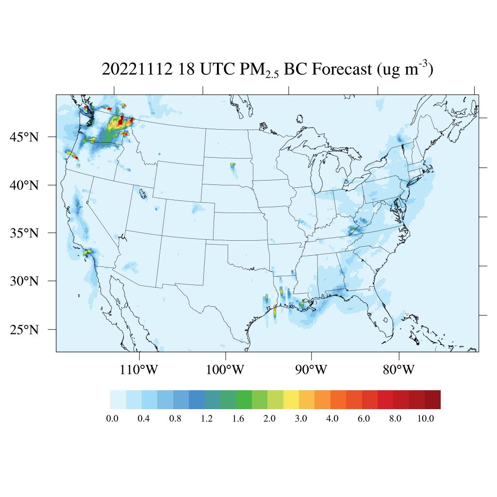
HAQES 3-Hourly Ensemble mean surface PM2.5 Black Carbon concentration, North America V1 (HAQES_NA_PM25_BC) at GES DISC
National Aeronautics and Space Administration —
This product provides HAQES 3-hourly ensemble mean surface PM2.5 Black Carbon concentration over the continental United States (CONUS) and surrounding regions. The... -
Federal
Global Multihazard Frequency and Distribution
National Aeronautics and Space Administration —
The Global Multihazard Frequency and Distribution is a 2.5 minute grid presenting a simple multihazard index based solely on summated single-hazard decile values. The...

Official websites use .gov
A
.gov website belongs to an official government
organization in the United States.
Secure .gov websites use HTTPS
A
lock (
) or https:// means you’ve safely connected to
the .gov website. Share sensitive information only on official,
secure websites.