
-
Federal
RapidScat Level 2B Ocean Wind Vectors in 12.5km Slice Composites Version 1.1
National Aeronautics and Space Administration —
This dataset contains the RapidScat Level 2B 12.5km Version 1.1 science-quality ocean surface wind vectors. The Level 2B wind vectors are binned on a 12.5 km Wind... -
Federal
RapidScat Level 2B Climate Ocean Wind Vectors in 12.5km Footprints Version 2.0
National Aeronautics and Space Administration —
This dataset contains the RapidScat Level 2B 12.5km Version 2.0 Climate quality ocean surface wind vectors. The Level 2B wind vectors are binned on a 12.5 km Wind... -
Federal
RapidScat Level 2B Ocean Wind Vectors in 12.5km Slice Composites Version 1.3
National Aeronautics and Space Administration —
This dataset contains the RapidScat Level 2B 12.5km Version 1.3 science-quality ocean surface wind vectors, which are intended as a replacement and continuation of... -
Federal
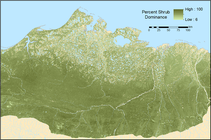
ABoVE: Gridded 30-m Aboveground Biomass, Shrub Dominance, North Slope, AK, 2007-2016
National Aeronautics and Space Administration —
This dataset includes 30-m gridded estimates of total plant aboveground biomass (AGB), the shrub AGB, and the shrub dominance (shrub/plant AGB) for non-water portions... -
Federal
RapidScat Level 2B Climate Ocean Wind Vectors in 12.5km Footprints
National Aeronautics and Space Administration —
This dataset contains the RapidScat Level 2B 12.5km Version 1.0 Climate quality ocean surface wind vectors. The Level 2B wind vectors are binned on a 12.5 km Wind... -
Federal
JPL TELLUS GRACE Level-3 Monthly Land Water-Equivalent-Thickness Surface Mass Anomaly Release 6.0 version 04 in netCDF/ASCII/GeoTIFF Formats
National Aeronautics and Space Administration —
The monthly land mass grids contain water mass anomalies given as equivalent water thickness derived from GRACE & GRACE-FO time-variable gravity observations... -
Federal
Western North American FLEXPART Back Trajectory 2007 Data
National Aeronautics and Space Administration —
WNA-FLEXPART-BackTraj-2007 is the 2007 Western North America Back Trajectory data using the FLEXible PARTicle (FLEXPART) dispersion model. Data collection for this... -
Federal
JPL TELLUS GRACE Level-3 Monthly Ocean Bottom Pressure Anomaly Release 6.0 version 04
National Aeronautics and Space Administration —
The monthly ocean bottom pressure anomaly grids are given as equivalent water thickness changes derived from GRACE & GRACE-FO time-variable gravity observations... -
Federal
RapidScat Level 1B Time-Ordered Geo-Located Sigma-0 Version 2.0
National Aeronautics and Space Administration —
This dataset contains the ISS-RapidScat Version 2.0 Level 1B geo-located Sigma-0 measurements and antenna pulse "egg" and "slice" geometries as derived from ephemeris... -
Federal
JPL TELLUS GRACE Level-3 Monthly Land Water-Equivalent-Thickness Surface Mass Anomaly Release 6.0 version 04
National Aeronautics and Space Administration —
The monthly land mass grids contain water mass anomalies given as equivalent water thickness derived from GRACE & GRACE-FO time-variable gravity observations... -
Federal
Western North American FLEXPART Back Trajectory 1999 Data
National Aeronautics and Space Administration —
WNA-FLEXPART-BackTraj-1999 is the 1999 Western North America Back Trajectory data using the FLEXible PARTicle (FLEXPART) dispersion model. Data collection for this... -
Federal
CSR TELLUS GRACE Level-3 Monthly Land Water-Equivalent-Thickness Surface Mass Anomaly Release 6.0 version 04
National Aeronautics and Space Administration —
The monthly land mass grids contain water mass anomalies given as equivalent water thickness derived from GRACE & GRACE-FO time-variable gravity observations... -
Federal
RapidScat Level 2A Surface Flagged Sigma-0 and Attenuations in 25km Swath Grid Version 2.0
National Aeronautics and Space Administration —
This dataset contains the Version 2.0 ISS-RapidScat Level 2A 25km science data record, which provides surface-flagged sigma-0 in 25km Wind Vector Cells processed... -
Federal
RapidScat Level 2A Surface Flagged Sigma-0 and Attenuations in 12.5km Swath Grid Version 2.0
National Aeronautics and Space Administration —
This dataset contains the Version 2.0 ISS-RapidScat on Level 2A 12.5 km science data record, which provides surface-flagged sigma-0 in 12.5 km Wind Vector Cells... -
Federal
Soil Organic Carbon Stock Estimates with Uncertainty across Latin America
National Aeronautics and Space Administration —
This dataset provides 5 x 5 km gridded estimates of soil organic carbon (SOC) across Latin America that were derived from existing point soil characterization data... -
Federal
Monthly gridded Global Land Data Assimilation System (GLDAS) from Noah-v3.3 land hydrology model for GRACE and GRACE-FO over nominal months
National Aeronautics and Space Administration —
The total land water storage anomalies are aggregated from the Global Land Data Assimilation System (GLDAS) NOAH model. GLDAS outputs land water content by using... -
Federal
Western North American FLEXPART Back Trajectory 2009 Data
National Aeronautics and Space Administration —
WNA-FLEXPART-BackTraj-2009 is the 2009 Western North America Back Trajectory data using the FLEXible PARTicle (FLEXPART) dispersion model. Data collection for this... -
Federal
Western North American FLEXPART Back Trajectory 2010 Data
National Aeronautics and Space Administration —
WNA-FLEXPART-BackTraj-2010 is the 2010 Western North America Back Trajectory data using the FLEXible PARTicle (FLEXPART) dispersion model. Data collection for this... -
Federal
Western North American FLEXPART Back Trajectory 2019 Data
National Aeronautics and Space Administration —
WNA-FLEXPART-BackTraj-2019 is the 2019 Western North America Back Trajectory data using the FLEXible PARTicle (FLEXPART) dispersion model. Data collection for this... -
Federal
Western North American FLEXPART Back Trajectory 2013 Data
National Aeronautics and Space Administration —
WNA-FLEXPART-BackTraj-2013 is the 2013 Western North America Back Trajectory data using the FLEXible PARTicle (FLEXPART) dispersion model. Data collection for this...

Official websites use .gov
A
.gov website belongs to an official government
organization in the United States.
Secure .gov websites use HTTPS
A
lock (
) or https:// means you’ve safely connected to
the .gov website. Share sensitive information only on official,
secure websites.