
-
Federal
ORACLES Trace Gas Aircraft InSitu Data
National Aeronautics and Space Administration —
ORACLES_TraceGas_AircraftInSitu_Data are in situ trace gas measurements collected onboard the P-3 Orion or ER-2 aircraft during the ObseRvations of Aerosols above... -
Federal
Global Land Cover Mapping and Estimation Yearly 30 m V001
National Aeronautics and Space Administration —
NASA's Making Earth System Data Records for Use in Research Environments (MEaSUREs) Global Land Cover Mapping and Estimation (GLanCE) annual 30 meter (m) Version 1... -
Federal
ORACLES Cloud Aircraft InSitu Data
National Aeronautics and Space Administration —
ORACLES_Cloud_AircraftInSitu_Data are in situ cloud measurements collected onboard the P-3 Orion or ER-2 aircraft during the ObseRvations of Aerosols above CLouds and... -
Federal
West Africa Coastal Vulnerability Mapping: Population Projections, 2030 and 2050
National Aeronautics and Space Administration —
The West Africa Coastal Vulnerability Mapping: Population Projections, 2030 and 2050 data set is based on an unreleased working version of the Gridded Population of... -
Federal
Country-Level Population and Downscaled Projections Based on the SRES A1, B1, and A2 Scenarios, 1990-2100
National Aeronautics and Space Administration —
The Country-Level Population and Downscaled Projections Based on Special Report on Emissions Scenarios (SRES) A1, B1, and A2 Scenarios, 1990-2100, were adopted in... -
Federal
Food Insecurity Hotspots Data Set
National Aeronautics and Space Administration —
The Food Insecurity Hotspots Data Set consists of grids at 250 meter (~7.2 arc-seconds) resolution that identify the level of intensity and frequency of food... -
Federal
SAFARI 2000 MODIS 500-m Burned Area Products, Southern Africa, Dry Season 2000
National Aeronautics and Space Administration —
The SAFARI 2000 project was selected as the first regional test for a prototype regional 500 m MODIS burned area product. The MODIS burned area product maps the 500 m... -
Federal
BioSCape: BioSoundSCape Acoustic Recordings, South Africa, 2023
National Aeronautics and Space Administration —
This dataset holds in situ sound recordings from sites in Greater Cape Floristic Region (GCFR), South Africa from June to December 2023. The recordings were collected... -
Federal
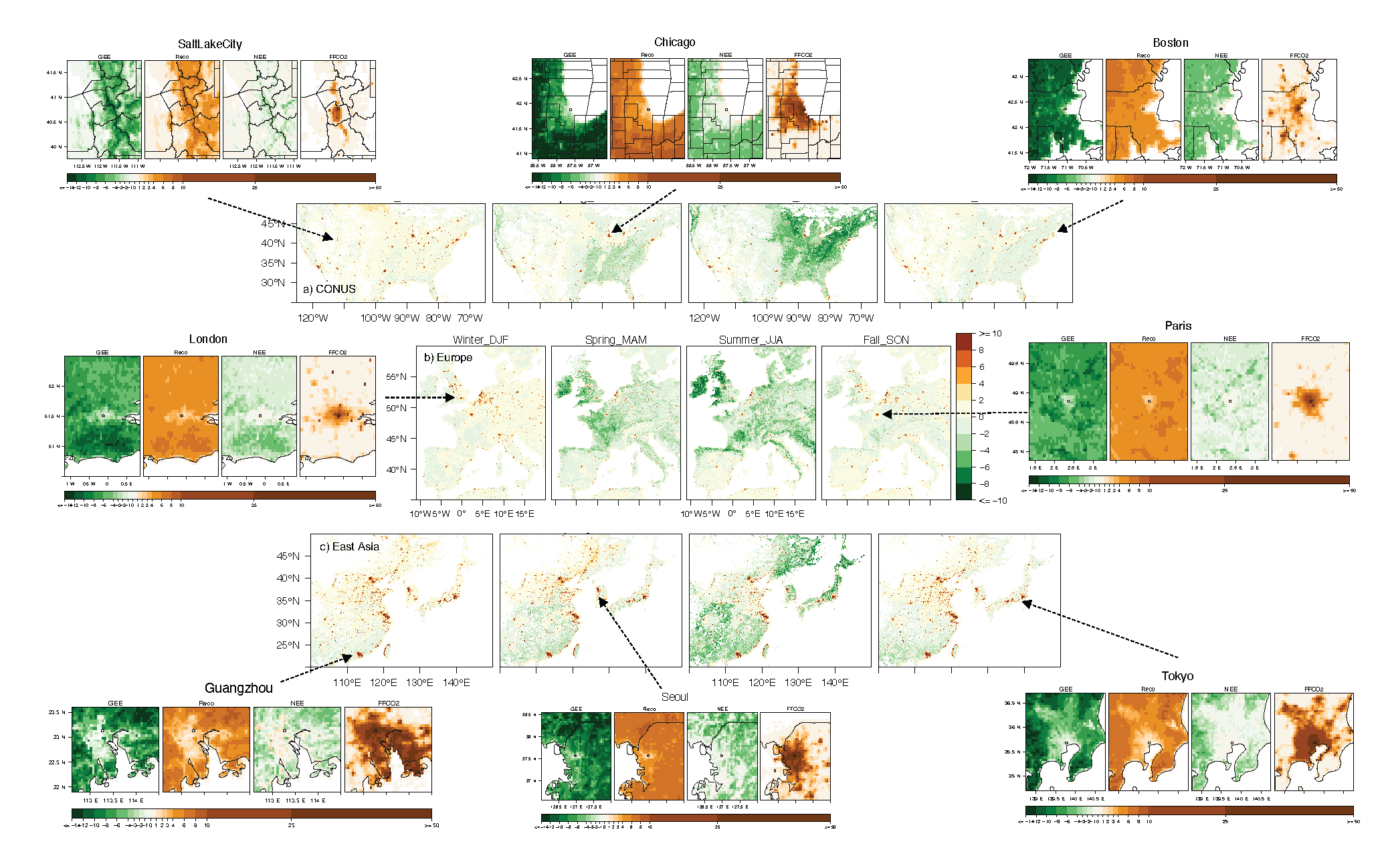
Urban Biogenic CO2 fluxes: GPP, Reco and NEE Estimates from SMUrF, 2010-2019
National Aeronautics and Space Administration —
This dataset contains estimates of biogenic CO2 flux components at 0.05 degree resolution from the Solar-Induced Fluorescence (SIF) for Modeling Urban biogenic Fluxes... -
Federal
Measurement of Air Pollution from Satellites (MAPS) Space Radar Laboratory - 2 (SRL2) Carbon Monoxide Second by Second data
National Aeronautics and Space Administration —
MAPS Overview The MAPS experiment measures the global distribution of carbon monoxide (CO) mixing ratios in the free troposphere. Because of MAPS' previous flights on... -
Federal
SAFARI 2000 Historical Fire Maps, Kruger National Park, 1992-2001
National Aeronautics and Space Administration —
Kruger National Park (KNP) was established in 1898 to protect wildlife on nearly 2 million hectares of the South African Lowveld. The climate in this region of South... -
Federal
West Africa Coastal Vulnerability Mapping: Economic Systems Index
National Aeronautics and Space Administration —
The West Africa Coastal Vulnerability Mapping: Economic Systems Index is a composite index based on several spatial indicators, including gridded Gross Domestic... -
Federal
SAFARI 2000 Fire Emission Data, Dry Season 2000
National Aeronautics and Space Administration —
As part of the Southern Africa Regional Science Initiative (SAFARI 2000), the University of Montana participated in both ground-based and airborne campaigns during... -
Federal
SAFARI 2000 Emissions Estimates, MODIS Burned Area Product, Dry Season 2000
National Aeronautics and Space Administration —
The recently generated MODIS burned area product over southern Africa for the month of September 2000 was used to calculate regional biomass burning emissions from... -
Federal
Biomass Burning 5x5 degree data in Native Format
National Aeronautics and Space Administration —
The BIO_MASS_5X5_HAO_NAT data set contains data representing the geographical and temporal distribution of total amount of biomass burned. The data were collected by... -
Federal
SAFARI 2000 SeaWiFS Images for the Southern African Region, 1999-2001
National Aeronautics and Space Administration —
This data set contains Sea-viewing Wide Field-of-view Sensor (SeaWiFS) imagery for the southern African region. These images are Level-1a swaths of the southern...

Official websites use .gov
A
.gov website belongs to an official government
organization in the United States.
Secure .gov websites use HTTPS
A
lock (
) or https:// means you’ve safely connected to
the .gov website. Share sensitive information only on official,
secure websites.