

12 datasets found for "Classification"
-
Federal
NACP North American Forest Dynamics Project: Forest Disturbance and Regrowth Data
National Aeronautics and Space Administration —
This data set provides the results of time-series analyses of Landsat imagery for 55 selected forested sites across the conterminous U.S.A. The output is a pair of... -
Federal
ABoVE: Riverbank Erosion and Vegetation Changes, Yukon River Basin, Alaska, 1984-2017
National Aeronautics and Space Administration —
This dataset provides a time series of riverbank erosion and vegetation colonization along reaches of the Yukon River (3 study areas), Tanana and Nenana Rivers (1... -
Federal
SAFARI 2000 Global Burned Area Map, 1-km, Southern Africa, 2000
National Aeronautics and Space Administration —
The Global Burned Area 2000 initiative (GBA2000) was launched by the Global Vegetation Mapping Unit of the Joint Research Centre of the European Commission, in... -
Federal
Arctic Vegetation Plots at Atqasuk, Alaska, 1975, 2000, and 2010
National Aeronautics and Space Administration —
This data set provides vegetation species abundance data collected in 1975 from 60 sites on the Arctic Coastal Plain near Atqasuk, Alaska, as well as environmental... -
Federal
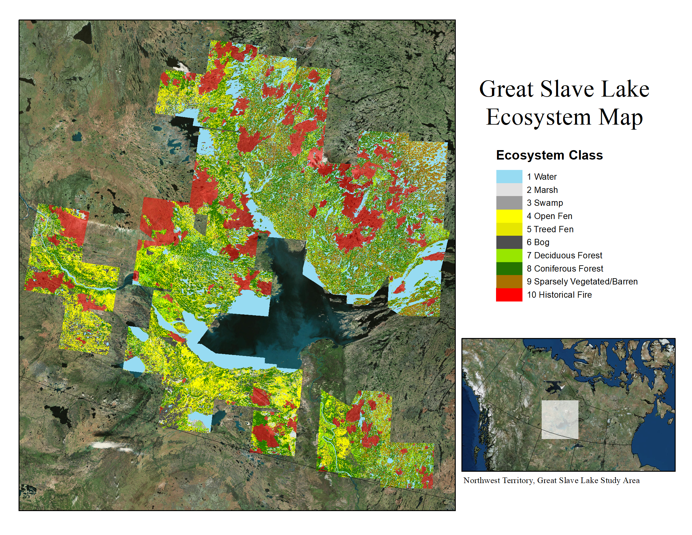
ABoVE: Ecosystem Map, Great Slave Lake Area, Northwest Territories, Canada, 1997-2011
National Aeronautics and Space Administration —
This dataset provides an ecosystem type map at 12.5 meter pixel spacing and 0.2 ha minimum mapping unit for the area surrounding Great Slave Lake, Northwest... -
Federal
ABoVE: Burn Severity, Fire Progression, Landcover and Field Data, NWT, Canada, 2014
National Aeronautics and Space Administration —
This data set provides peatland landcover classification maps, fire progression maps, and vegetation community biophysical data collected from areas that were burned... -
Federal
NACP Integrated Wildland and Cropland 30-m Fuel Characteristics Map, U.S.A., 2010
National Aeronautics and Space Administration —
The data set provides a 30-m comprehensive fuelbed characteristics map for both the wildland and cropland areas of the conterminous United States (CONUS) for 2010.... -
Federal
BOREAS Agriculture Canada Central Saskatchewan Vector Soils Data, R1
National Aeronautics and Space Administration —
This data set provides soil descriptions for forested areas in the BOREAS southern study area (SSA) in central Saskatchewan, Canada provided by Agriculture Canada.... -
Federal
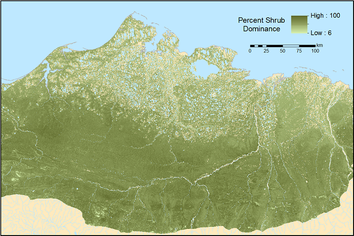
ABoVE: Gridded 30-m Aboveground Biomass, Shrub Dominance, North Slope, AK, 2007-2016
National Aeronautics and Space Administration —
This dataset includes 30-m gridded estimates of total plant aboveground biomass (AGB), the shrub AGB, and the shrub dominance (shrub/plant AGB) for non-water portions... -
Federal
ABoVE: Wetland Type, Slave River and Peace-Athabasca Deltas, Canada, 2007 and 2017
National Aeronautics and Space Administration —
This dataset provides ecosystem-types for the Slave River Delta (SRD) and Peace-Athabasca Delta (PAD), Canada, for the time periods circa 2007 and circa 2017. The... -
Federal
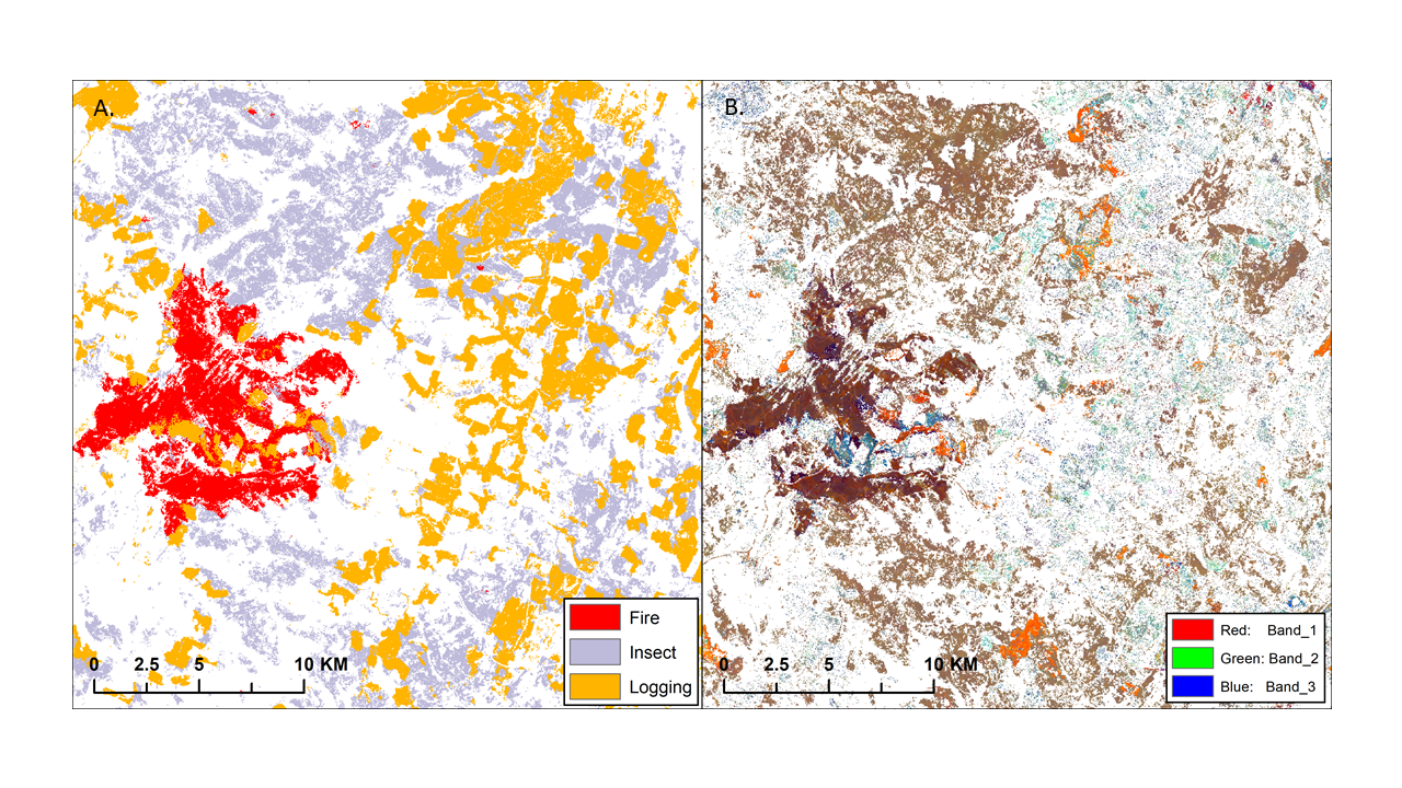
ABoVE: Landsat-derived Annual Disturbance Agents Across ABoVE Core Domain, 1987-2012
National Aeronautics and Space Administration —
This dataset provides spatial data on disturbance agents of fire, insects, and logging in the Arctic Boreal Vulnerability Experiment (ABoVE) core domain at an annual... -
Federal
ABoVE: Vegetation Composition across Fire History Gradients on the Y-K Delta, Alaska
National Aeronautics and Space Administration —
This dataset provides ecological field data that were collected during July 2017 and July 2018 from 43 plots spanning gradients of fire history in the upland tundra...
12 datasets found for "Classification"